Jezero[a] (ICAO: JZRO) is a crater on Mars in the Syrtis Major quadrangle,[3] about 45.0 km (28.0 mi) in diameter. Thought to have once been flooded with water, the crater contains a fan-delta deposit rich in clays.[4] The lake in the crater was present when valley networks were forming on Mars. Besides having a delta, the crater shows point bars and inverted channels. From a study of the delta and channels, it was concluded that the lake inside the crater probably formed during a period in which there was continual surface runoff.[5]
 First full-color image transmitted by Perseverance from Jezero | |
| Planet | Mars |
|---|---|
| Coordinates | 18°23′N 77°35′E / 18.38°N 77.58°E |
| Quadrangle | Syrtis Major |
| Diameter | 45 km (28 mi)[1] |
| Eponym | Jezero, Bosnia and Herzegovina |

In 2007, following the discovery of its ancient lake, the crater was named after Jezero, Bosnia and Herzegovina, one of several eponymous towns in the country.[6][7] In some Slavic languages, the word jezero[b] means 'lake'.[8]
In November 2018, it was announced that Jezero had been chosen as the landing site for the rover Perseverance as part of NASA's Mars 2020 mission.[9][10][11] In November 2020, evidence of boulder falls was found on the slopes of the delta deposits that the rover is planned to explore, on the wall of Jezero itself as well as on the wall of Dacono,[12] a small crater 2 km (1.2 mi) in diameter on the floor of Jezero.[13] Perseverance successfully landed in the crater on 18 February 2021.[14] On 5 March 2021, NASA named the landing site of the rover Octavia E. Butler Landing.[15]
Local features
- Séítah (pronounced /sei˥tʰa˩x/, meaning 'amidst the sand' in Navajo) – potentially the oldest accessible geologic units in Jezero Crater with multiple outcrops between the numerous sand ripples; location where Perseverance started the first year of its scientific campaign and took the first core samples.[16]
In December 2021, NASA announced that some of the rocks in Jezero in Séítah were igneous. When examined closely, rocks revealed the mineral olivine surrounded by the mineral pyroxene. That arrangement happens in thick magma bodies and geologists call this type of texture "Cumulate."[17] Carbonate and sulfate minerals were also detected which means that the rocks had been altered by water.[18] The instrument used for this analysis was the Planetary Instrument for X-Ray Lithochemistry (PIXL).[19]
Crater
In a March 2015 paper, researchers from Brown University described how an ancient Martian lake system existed in Jezero. The study advanced the idea that water filled the crater at least two separate times.[20] There are two channels on the northern and western sides of the crater that probably supplied it with water; each of these channels has a delta-like deposit where sediment was carried by water and deposited in the lake.[21] Craters of a given diameter are expected to have a certain depth; a depth less than expected means sediment entered the crater.[22] Calculations suggest that the crater may hold about 1 kilometre (0.62 mi) of sediments. Most of the sediments may have been brought in by channels.[23]
Since it is believed that the lake was long-lived, life may have developed in the crater; the delta may have required a period of one to ten million years to form.[23] Clay minerals have been detected in and around the crater.[24][25][26] The Mars Reconnaissance Orbiter identified smectite clays.[27] Clays form in the presence of water, so this area probably once held water and maybe life in ancient times. The surface in places is cracked into polygonal patterns; such shapes often form when clay dries out. The image below depicts examples of these patterns, and a channel that carried water and sediments into the crater.[3]
Geologic map of Jezero and the Nili Planum region | .jpg) Elevation map of Jezero. Ancient rivers Neretva and Sava fed the crater from NW until the overflow flooding carved the outlet Pliva at the NE side of the crater rim  Perseverance's landing site in Jezero  Artist's concept of Jezero filled with a lake |


Exploration
Mars 2020 mission
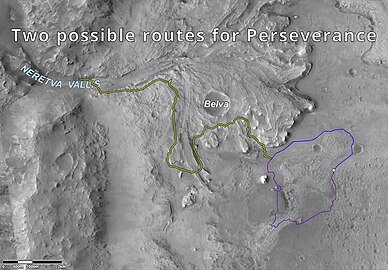 Possible routes for Perseverance for exploration and study in Jezero


Jezero, once considered a site for the Mars Science Laboratory, was later proposed as a landing site for NASA's Mars 2020 mission, carrying the rover Perseverance and the helicopter Ingenuity.[28][29] In early 2017 it was selected as one of the top three candidate landing sites, along with northeast Syrtis, 30 km (19 mi) to the southwest.[30]
A primary aim of the Mars 2020 mission is to search for signs of ancient life. It is hoped that a later mission could then return Martian samples from sites identified as probably containing remains of life. To safely bring the craft down, a 12-mile (19 km) wide, smooth, flat circular area is needed. Geologists hope to examine places where water once ponded.[31] They would like to examine sediment layers.
In November 2018, Jezero was selected as the target landing site for Mars 2020.[32] On 18 February 2021, Perseverance landed successfully in the crater.[33] On 19 April 2021, Ingenuity performed the first powered flight on Mars from Jezero, which received the commemorative ICAO airport code JZRO.[34]
Mars Sample Retrieval Lander
An ESA–NASA team produced a three-launch architecture concept for a Mars sample return, which uses the Mars 2020 rover to cache small samples, a two-stage, solid-fueled Mars ascent stage to send it into orbit, and an orbiter to rendezvous with it above Mars and take it to Earth.[35] Solar electric propulsion could allow a one launch sample return instead of three.[36] So, after a launch in July 2026, a lander with a Mars ascent rocket (developed by NASA) with two sample recovery helicopters lands exactly near the Mars 2020 rover at Three Forks in Jezero Crater in August 2028. The collected samples by Mars 2020 are delivers them to the ascent rocket. Once loaded with the samples, the Mars ascent rocket will launch with the sample return canister in spring 2029 and reach a low Mars orbit.
This design would ease the schedule of the whole project, giving controllers time and flexibility to carry out the required operations. Furthermore, the program could rely on the successful landing system developed for the Mars Science Laboratory, avoiding the costs and risks associated with developing and testing yet another landing system from scratch.[37] In addition, NASA may change the solar panels on lander with Radioisotope Thermoelectric Generator, a nuclear power source, to ensure sufficient power and to keep the rocket’s propulsion system from getting too cold, thus ensuring a longer lifetime, better thermal protection and safe operation even if they are carried in Mars Global Dust Storm Season, but these changes are still to be clarified by NASA.
Discoveries
In 2022, the Perseverance Rover detected organic molecules in the crater.[38][39]
Although it was believed that Jezero was a lake, Perseverance found igneous rocks.[40][41] The rocks were once molten and then slowly cooled. They contained the mineral olivine surrounded by the mineral pyroxene which happens in thick magma bodies. Such a texture is called "Cumulate."[42] The rocks had also been changed by water since carbonate and sulfate minerals were also found. The rocks studied were in location nicknamed "South Séítah." "Séítah" (means "amidst the sand" in the Navajo language.[43] The Planetary Instrument for X-ray Lithochemistry (PIXL) was used for this analysis.[44]
Perseverance detected many dust devils. On a typical Martian day at least four dust devils pass Perseverance. At a peak hour long period just after noon, more than one per hour passes. Perseverance made these observations mostly with its cameras and a group of sensors in the Mars Environmental Dynamics Analyzer (MEDA). MEDA includes wind sensors and light sensors.[45][46]
Interactive Mars map

 Clickable image: Clicking on the labels will open a new article.


Gallery
 Dust storm on Mars - Jezero crater (white circle) (9 January 2022)

See also
- Astrobiology – Science concerned with life in the universe
- Climate of Mars – Climate patterns of the planet Mars
- Composition of Mars – Branch of the geology of Mars
- Exploration of Mars – Overview of the exploration of Mars
- Geology of Mars – Scientific study of the surface, crust, and interior of the planet Mars
- Impact crater – Circular depression in a solid astronomical body formed by the impact of a smaller object
- Inverted relief – Landscape features that have reversed their elevation relative to other features
- Lakes on Mars – Overview of the presence of lakes on Mars
- List of craters on Mars
- Mars landing – Landing of a spacecraft on the surface of Mars
- Water on Mars – Study of past and present water on Mars
Notes
References
Further reading
- Ehlmann, B.L.; Mustard, John F.; Fassett, Caleb I.; Schon, Samuel C.; Head Iii, James W.; Des Marais, David J.; Grant, John A.; Murchie, Scott L. (2008). "Clay minerals in delta deposits and organic preservation potential on Mars" (PDF). Nature Geoscience. 1 (6): 355–358. Bibcode:2008NatGe...1..355E. doi:10.1038/ngeo207.
- Schon; et al. (2008). Meander Loops and Point Bar Sequences – Evidence of a Stable Delta Plain Environment in Jezero crater (PDF). Lunar and Planetary Sciences conference.
External links
- Jezero Crater – DataSheet (14 January 2017)
- Jezero Crater – Workshop Images/Details (4 August 2015)
- Perseverance rover: Official website
- Mars 2020: Official website
- Mars 2020: Location Maps
- Video – FlyOver bw (01:20) and color (02:20) (SDoran; 21 April 2017)
- Video – Mars 2020 Site News (01:00) (NASA; 19 November 2018)
- Video – Mars 2020 Site News (00:50) (MSN; 19 November 2018)
- Video – Mars 2020: Jezero crater flyover (02:13) (NASA; 13 December 2018)
- Video − Mars 2020: Landing on Mars (3:25) on YouTube (NASA; 18 February 2021)
- Video (60:00) – Minerals and the Origins of Life – (Robert Hazen; NASA; April 2014)
- Video (86:49) – Search for Life in the Universe – (NASA; July 2014)


