The Kabul River (Pashto: د کابل سیند, Dari: دریای کابل), the classical Cophen /ˈkoʊfeɪn/, is a river that emerges in the Sanglakh Range of the Hindu Kush mountains in the northeastern part of Maidan Wardak Province, Afghanistan. It is separated from the watershed of the Helmand River by the Unai Pass. The Kabul River is a tributary of the Indus River, flowing into it near Attock, Pakistan. The Kabul is the main river in eastern Afghanistan and in the Khyber Pakhtunkhwa province of Pakistan.
| Kabul River | |
|---|---|
 Aerial photo of Kabul River flood-plain east of Kabul, Afghanistan | |
 Path of the Kabul River [1] | |
 Mouth of the Kabul River in Pakistan | |
| Etymology | Kabul's River in Dari/Persian |
| Native name | Daryā-ye Kābol (Pashto) |
| Location | |
| Countries | Afghanistan and Pakistan |
| Cities | Kabul, Surobi, Jalalabad (Afghanistan); Peshawar, Charsadda, Nowshera (Pakistan) |
| Physical characteristics | |
| Source | Hindu Kush Mountains |
| • location | Maidan Wardak, Afghanistan |
| • coordinates | 34°21′25″N 68°50′21″E / 34.357°N 68.8392°E |
| • elevation | 2,400 m (7,900 ft) |
| Mouth | Indus River |
• location | Attock, Punjab, Pakistan |
• coordinates | 33°55′0″N 72°13′56″E / 33.91667°N 72.23222°E |
| Length | 700 km (430 mi) |
| Basin size | 70,500 km2 (27,200 sq mi) |
| Basin features | |
| Tributaries | |
| • left | Panjshir River, Alingar River, Kunar River, Swat River |
| • right | Logar River, Surkhab River, Bara River |
Course
The Kabul River, which measures 700 kilometres or 430 miles long, passes through the cities of Kabul and Jalalabad in Afghanistan. Its large drainage basin covers the eastern provinces of Nangarhār, Kunar, Laḡmān, Lōgar, Kabul, Kāpisā, Parvān, Panjšēr, and Bāmiān before it flows into Khyber Pakhtunkhwa in Pakistan some 25 kilometres (16 mi) north of the Durand Line border crossing at Torkham.[1] In Khyber Pakhtunkhwa, the river passes through the cities of Peshawar, Charsadda, and Nowshera. A majority of the Kabul River’s water originates from the snow and glaciers of Chitral District, out of which it flows into Afghanistan. In its upper reaches it is known as the Sarchashma. The major tributaries of the Kabul River are the Logar, Panjshir, Alingar, Surkhab, Kunar, Bara, and Swat rivers.[2]

Hydrology
The Kabul River is little more than a trickle for most of the year, but swells in summer due to melting snows in the Hindu Kush Range. Its largest tributary is the Kunar River, which starts out as the Mastuj River, flowing from the Chiantar glacier in Brughil valley in Chitral, Pakistan and after flowing south into Afghanistan it is met by the Bashgal river flowing from Nurestan. The Kunar meets the Kabul near Jalalabad. In spite of the Kunar carrying more water than the Kabul, the river continues as the Kabul River after this confluence, mainly for the political and historical significance of the name.
Dams
The Kabul River is impounded by several dams that were constructed in the 20th century. Three dams are located in the Kabul and Nangarhar provinces of Afghanistan, including the Surobi dam, a hydroelectric source for Kabul constructed 1957 with assistance by Germany, the Naghlu dam, which was later built by Soviet scientists in the 1960s, and the Darunta dam. The Warsak Dam is also in the Valley of Peshawar in Pakistan, approximately 20 km northwest of the city of Peshawar.[1]
History
Expedition of Alexander the Great into Asia
In Arrian's The Campaigns of Alexander, the River Kabul is referred to as Κωφήν Kōphēn (Latin spelling Cophen).[3][4][5][6]
Modern era
Since the 1990s, the river has experienced substantial droughts in summer.[1] In approximately March 2019, ten of thousands of gallons of untreated sewage from the Makroyan Waste Water Treatment Plant has been dumped into the Kabul River each month, reportedly causing gastrointestinal issues among the 3,000 families that live along the river.[7]
Etymology
In Sanskrit and Avestan
The word Kubhā which is the ancient name of the river is both a Sanskrit and Avestan word. The word later changed to Kābul.[8][9]
Al-Biruni
Al-Biruni a Persian polymath also called it "the River of Ghorwand".[10]
The Kabul River later gave its name to the region and to the settlement of Kabul.[10]
Institution Leadership
Kabul River Basin (KRB) is a government authority under the Ministry of Energy and Water (MEW) of the Government of the Islamic Republic of Afghanistan (GoIRA). Based on the Water Law it was created. The recent Director General of this major water institution was Jalal Naser Faqiryar, who brought positive changes, contributed a lot to the transparency, basin development, and applicable policies, especially river basin management which had positive impacts and results.
Gallery
 The Kabul River in the city of Kabul, 1966
 The Kabul River in the city of Kabul, 1982
 The Kabul River in the city of Kabul in 2009, now dried up
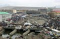 The dried river in the central city of Kabul
 Kabul River valley
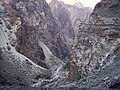 Gorge of the Kabul River, parallel to the Kabul-Jalalabad Road
 Kabul River in Behsood Bridge Area, Jalalabad, 2009
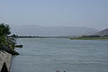 Kabul River in Behsood Bridge Area, Jalalabad, 2009
 Buddhist caves, which have been carved into a set of cliffs on the north side of the Kabul river
 A dam on the river
 Kabul River at Behsood Bridge , Jalalabad


.jpg)
