Quintana Roo is a state in southeast Mexico established out of the Quintana Roo Territory in 1974 with seven municipalities, which has since grown into eleven municipalities. According to the 2020 Mexican census, it has the twenty-fourth largest population of all states with 1,857,985 inhabitants and is the 19th largest by land area spanning 44,705.2 square kilometres (17,260.8 sq mi).[1][2]
.svg)
Municipalities in Quintana Roo are administratively autonomous of the state according to the 115th article of the 1917 Constitution of Mexico.[3] Their legal framework derives from the state Constitution.[4] Every three years, citizens elect a municipal president (Spanish: presidente municipal) by a plurality voting system. The president heads a concurrently elected municipal council (ayuntamiento) responsible for providing public services for their constituents. The municipal council consists of trustees and councillors (regidores y síndicos).[5] Municipalities are responsible for public services (such as water and sewerage), street lighting, public safety, traffic, and the maintenance of public parks, gardens and cemeteries.[6] They may also assist the state and federal governments in education, emergency fire and medical services, environmental protection and maintenance of monuments and historical landmarks. Since 1984, they have had the power to collect property taxes and user fees, although more funds are obtained from the state and federal governments than locally.[6]
As of 2020, the largest municipality by population is Benito Juárez with 911,503 residents while the smallest is Isla Mujeres with 22,686 residents.[1] The largest municipality by land area is Felipe Carrillo Puerto which spans 12,939.30 km2 (4,995.89 sq mi), and the smallest is Cozumel with 488.00 km2 (188.42 sq mi).[2]The newest municipality is Puerto Morelos which was created out of Benito Juárez in 2016.[7]
Municipalities

- Largest municipalities in Quintana Roo by population
 Benito Juárez, the municipality containing Cancún, is the largest municipality by population in Quintana Roo.
 Solidaridad, second largest municipality by population
 Othón P. Blanco is the third largest municipality by population and contains the state capital.
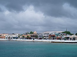 Cozumel is the fourth largest municipality by population.
.jpg)


| Name | Municipal seat | Population (2020)[1] | Population (2010)[8] | Change | Land area[2] | Population density (2020) | Incorporation date[9] | |
|---|---|---|---|---|---|---|---|---|
| km2 | sq mi | |||||||
| Bacalar[a] | Bacalar | 41,754 | — | — | 6,058.5 | 2,339.2 | 6.9/km2 (17.8/sq mi) | February 2, 2011[10] |
| Benito Juárez | Cancún | 911,503 | 661,176 | +37.9% | 930.7 | 359.3 | 979.4/km2 (2,536.6/sq mi) | January 12, 1975 |
| Cozumel | San Miguel de Cozumel | 88,626 | 79,535 | +11.4% | 488.0 | 188.4 | 181.6/km2 (470.4/sq mi) | April 21, 1862 |
| Felipe Carrillo Puerto[b] | Felipe Carrillo Puerto | 83,990 | 75,026 | +11.9% | 12,938.3 | 4,995.5 | 6.5/km2 (16.8/sq mi) | February 27, 1904 |
| Isla Mujeres | Isla Mujeres | 22,686 | 16,203 | +40.0% | 862.5 | 333.0 | 26.3/km2 (68.1/sq mi) | July 24, 1867 |
| José María Morelos | José María Morelos | 39,165 | 36,179 | +8.3% | 4,850.0 | 1,872.6 | 8.1/km2 (20.9/sq mi) | January 12, 1975 |
| Lázaro Cárdenas | Kantunilkín | 29,171 | 25,333 | +15.2% | 3,593.3 | 1,387.4 | 8.1/km2 (21.0/sq mi) | January 12, 1975 |
| Othón P. Blanco[c] | Chetumal† | 233,648 | 244,553 | −4.5% | 9,909.8 | 3,826.2 | 23.6/km2 (61.1/sq mi) | February 27, 1904 |
| Puerto Morelos | Puerto Morelos | 26,921 | — | — | 1,040.5 | 401.7 | 25.9/km2 (67.0/sq mi) | January 6, 2016[7] |
| Solidaridad | Playa del Carmen | 333,800 | 159,310 | +109.5% | 2,014.9 | 778.0 | 165.7/km2 (429.1/sq mi) | July 28, 1993 |
| Tulum | Tulum | 46,721 | 28,263 | +65.3% | 2,018.6 | 779.4 | 23.1/km2 (59.9/sq mi) | March 13, 2008[11] |
| Quintana Roo | — | 1,857,985 | 1,325,578 | +40.2% | 44,705.2 | 17,260.8 | 41.6/km2 (107.6/sq mi) | — |
| Mexico | — | 126,014,024 | 112,336,538 | +12.2% | 1,960,646.7 | 757,010 | 64.3/km2 (166.5/sq mi) | — |