San Luis Potosí is a state in North Central Mexico that is divided into 58 municipalities. According to the 2020 Mexican census, it is the 19th most populated of Mexico's 31 states, with 2,822,255 inhabitants and the 15th largest by land area spanning 61,138.0 square kilometres (23,605.5 sq mi).[1][2] The largest municipality by population is the city of San Luis Potosí, with 911,908 residents (32.31% of the state's total), while the smallest is Armadillo with 4,013 residents.[1] The largest municipality by land area is Santo Domingo which spans 4,322.60 km2 (1,669.0 sq mi), and the smallest is Huehuetlán with 71.50 km2 (27.61 sq mi).[2] The newest municipalities are El Naranjo, created out of Ciudad del Maíz, and Matlapa, carved from Tamazunchale, both established in 1994.[3]
.svg)
Municipalities in San Luis Potosi are administratively autonomous of the state according to the 115th article of the 1917 Constitution of Mexico.[4] Every three years, citizens elect a municipal president (Spanish: presidente municipal) by a plurality voting system who heads a concurrently elected municipal council (ayuntamiento) responsible for providing all the public services for their constituents. The municipal council consists of a variable number of trustees and councillors (regidores y síndicos).[5] Municipalities are responsible for public services (such as water and sewerage), street lighting, public safety, traffic, and the maintenance of public parks, gardens and cemeteries.[6] They may also assist the state and federal governments in education, emergency fire and medical services, environmental protection and maintenance of monuments and historical landmarks. Since 1984, they have had the power to collect property taxes and user fees, although more funds are obtained from the state and federal governments than from their own income.[6]
Municipalities
- Largest municipalities in San Luis Potosí by population
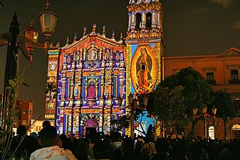 San Luis Potosí is the capital and most populous municipality in San Luis Potosí.
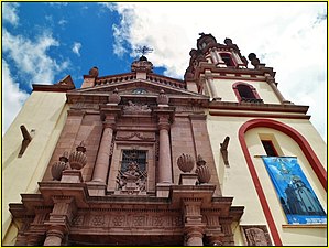 Soledad, second largest municipality by population in San Luis Potosí
 Ciudad Valles is the third most populous municipality in San Luis Potosí.
 Matehuala, fourth largest municipality by population


| Name | Municipal seat | Population (2020)[1] | Population (2010)[7] | Change | Land area[2] | Population density (2020) | Incorporation date[3] | |
|---|---|---|---|---|---|---|---|---|
| km2 | sq mi | |||||||
| Ahualulco | Ahualulco | 18,974 | 18,644 | +1.8% | 775.4 | 299.4 | 24.5/km2 (63.4/sq mi) | October 29, 1823 |
| Alaquines | Alaquines | 7,785 | 8,186 | −4.9% | 586.2 | 226.3 | 13.3/km2 (34.4/sq mi) | July 19, 1826 |
| Aquismón | Aquismón | 48,359 | 47,423 | +2.0% | 794.2 | 306.6 | 60.9/km2 (157.7/sq mi) | July 19, 1826 |
| Armadillo | Armadillo de los Infante | 4,013 | 4,436 | −9.5% | 623.4 | 240.7 | 6.4/km2 (16.7/sq mi) | July 19, 1826 |
| Axtla[a] | Axtla de Terrazas | 32,544 | 33,245 | −2.1% | 191.2 | 73.8 | 170.2/km2 (440.8/sq mi) | July 19, 1826 |
| Cárdenas | Cárdenas | 18,317 | 18,937 | −3.3% | 390.5 | 150.8 | 46.9/km2 (121.5/sq mi) | November 16, 1920 |
| Catorce | Real de Catorce | 9,579 | 9,716 | −1.4% | 1,944.9 | 750.9 | 4.9/km2 (12.8/sq mi) | July 19, 1826 |
| Cedral | Cedral | 19,840 | 18,485 | +7.3% | 1,169.4 | 451.5 | 17.0/km2 (43.9/sq mi) | July 19, 1826 |
| Cerritos | Cerritos | 22,075 | 21,394 | +3.2% | 962.4 | 371.6 | 22.9/km2 (59.4/sq mi) | October 5, 1827 |
| Cerro de San Pedro | Cerro de San Pedro | 5,050 | 4,021 | +25.6% | 122.6 | 47.3 | 41.2/km2 (106.7/sq mi) | July 19, 1826 |
| Charcas | Charcas | 21,814 | 21,138 | +3.2% | 2,156.7 | 832.7 | 10.1/km2 (26.2/sq mi) | July 19, 1826 |
| Ciudad del Maíz[b] | Ciudad del Maíz | 30,320 | 31,323 | −3.2% | 3,150.4 | 1,216.4 | 9.6/km2 (24.9/sq mi) | July 19, 1826 |
| Ciudad Fernández [c] | Ciudad Fernández | 48,106 | 43,528 | +10.5% | 518.4 | 200.2 | 92.8/km2 (240.3/sq mi) | July 19, 1826 |
| Ciudad Valles[d] | Ciudad Valles | 179,371 | 167,713 | +7.0% | 2,423.6 | 935.8 | 74.0/km2 (191.7/sq mi) | July 19, 1826 |
| Coxcatlán | Coxcatlán | 15,660 | 17,015 | −8.0% | 90.9 | 35.1 | 172.3/km2 (446.2/sq mi) | July 19, 1826 |
| Ébano | Ébano | 40,899 | 41,529 | −1.5% | 698.5 | 269.7 | 58.6/km2 (151.7/sq mi) | June 6, 1963 |
| El Naranjo | El Naranjo | 20,959 | 20,495 | +2.3% | 821.3 | 317.1 | 25.5/km2 (66.1/sq mi) | December 2, 1994 |
| Guadalcázar | Guadalcázar | 25,119 | 25,985 | −3.3% | 3,745.9 | 1,446.3 | 6.7/km2 (17.4/sq mi) | July 19, 1826 |
| Huehuetlán[e] | Huehuetlán | 15,334 | 15,311 | +0.2% | 71.5 | 27.6 | 214.5/km2 (555.5/sq mi) | July 19, 1826 |
| Lagunillas | Lagunillas | 5,453 | 5,774 | −5.6% | 535.5 | 206.8 | 10.2/km2 (26.4/sq mi) | October 5, 1827 |
| Matehuala | Matehuala | 102,199 | 91,522 | +11.7% | 1,301.7 | 502.6 | 78.5/km2 (203.3/sq mi) | July 19, 1826 |
| Matlapa | Matlapa | 28,996 | 30,299 | −4.3% | 117.2 | 45.3 | 247.4/km2 (640.8/sq mi) | December 2, 1994 |
| Mexquitic[f] | Mexquitic de Carmona | 58,469 | 53,442 | +9.4% | 877.1 | 338.7 | 66.7/km2 (172.7/sq mi) | July 19, 1826 |
| Moctezuma[g] | Moctezuma | 19,036 | 19,327 | −1.5% | 1,291.5 | 498.7 | 14.7/km2 (38.2/sq mi) | July 19, 1826 |
| Rayón[h] | Rayón | 15,301 | 15,707 | −2.6% | 786.4 | 303.6 | 19.5/km2 (50.4/sq mi) | July 19, 1826 |
| Rioverde | Rioverde | 97,943 | 91,924 | +6.5% | 3,064.0 | 1,183.0 | 32.0/km2 (82.8/sq mi) | July 19, 1826 |
| Salinas | Salinas de Hidalgo | 31,107 | 30,190 | +3.0% | 1,729.9 | 667.9 | 18.0/km2 (46.6/sq mi) | July 19, 1826 |
| San Antonio[i] | San Antonio | 9,382 | 9,390 | −0.1% | 94.7 | 36.6 | 99.1/km2 (256.6/sq mi) | July 19, 1826 |
| San Ciro | San Ciro de Acosta | 10,215 | 10,171 | +0.4% | 639.2 | 246.8 | 16.0/km2 (41.4/sq mi) | February 16, 1853 |
| San Luis Potosí | San Luis Potosí† | 911,908 | 772,604 | +18.0% | 1,482.0 | 572.2 | 615.3/km2 (1,593.7/sq mi) | July 19, 1826 |
| San Martín Chalchicuautla | San Martín Chalchicuautla | 18,468 | 21,347 | −13.5% | 413.1 | 159.5 | 44.7/km2 (115.8/sq mi) | July 19, 1826 |
| San Nicolás Tolentino | San Nicolás Tolentino | 4,779 | 5,466 | −12.6% | 692.4 | 267.3 | 6.9/km2 (17.9/sq mi) | July 19, 1826 |
| Santa Catarina | Santa Catarina | 12,163 | 11,835 | +2.8% | 640.6 | 247.3 | 19.0/km2 (49.2/sq mi) | November 6, 1876 |
| Santa María del Río | Santa María del Río | 39,880 | 40,326 | −1.1% | 1,701.0 | 656.8 | 23.4/km2 (60.7/sq mi) | July 19, 1826 |
| Santo Domingo | Santo Domingo | 10,785 | 12,043 | −10.4% | 4,322.6 | 1,669.0 | 2.5/km2 (6.5/sq mi) | December 24, 1857 |
| Soledad | Soledad de Graciano Sánchez | 332,072 | 267,839 | +24.0% | 305.7 | 118.0 | 1,086.3/km2 (2,813.4/sq mi) | July 19, 1826 |
| Tamasopo[j] | Tamasopo | 29,184 | 28,848 | +1.2% | 1,322.9 | 510.8 | 22.1/km2 (57.1/sq mi) | July 19, 1826 |
| Tamazunchale | Tamazunchale | 95,037 | 96,820 | −1.8% | 353.7 | 136.6 | 268.7/km2 (695.9/sq mi) | July 19, 1826 |
| Tampacán | Tampacán | 14,348 | 15,838 | −9.4% | 187.3 | 72.3 | 76.6/km2 (198.4/sq mi) | December 14, 1861 |
| Tampamolón | Tampamolón Corona | 13,603 | 14,274 | −4.7% | 262.7 | 101.4 | 51.8/km2 (134.1/sq mi) | July 19, 1826 |
| Tamuín | Tamuín | 36,968 | 37,956 | −2.6% | 1,843.3 | 711.7 | 20.1/km2 (51.9/sq mi) | July 19, 1826 |
| Tancanhuitz[k] | Tancanhuitz de Santos | 20,300 | 21,039 | −3.5% | 137.4 | 53.1 | 147.7/km2 (382.7/sq mi) | July 19, 1826 |
| Tancuayalab | San Vicente Tancuayalab | 14,945 | 14,958 | −0.1% | 518.7 | 200.3 | 28.8/km2 (74.6/sq mi) | July 19, 1826 |
| Tanlajás | Tanlajás | 18,208 | 19,312 | −5.7% | 374.8 | 144.7 | 48.6/km2 (125.8/sq mi) | July 19, 1826 |
| Tanquián | Tanquián de Escobedo | 13,448 | 14,382 | −6.5% | 143.4 | 55.4 | 93.8/km2 (242.9/sq mi) | November 26, 1870 |
| Tierra Nueva[l] | Tierra Nueva | 7,966 | 9,024 | −11.7% | 478.6 | 184.8 | 16.6/km2 (43.1/sq mi) | July 19, 1826 |
| Vanegas | Vanegas | 7,557 | 7,902 | −4.4% | 2,799.5 | 1,080.9 | 2.7/km2 (7.0/sq mi) | November 10, 1922 |
| Venado | Venado | 14,188 | 14,492 | −2.1% | 1,301.0 | 502.3 | 10.9/km2 (28.2/sq mi) | July 19, 1826 |
| Villa de Arista[m] | Villa de Arista | 17,258 | 15,528 | +11.1% | 586.7 | 226.5 | 29.4/km2 (76.2/sq mi) | October 13, 1857 |
| Villa de Arriaga | Villa de Arriaga | 18,206 | 16,316 | +11.6% | 878.1 | 339.0 | 20.7/km2 (53.7/sq mi) | May 7, 1874 |
| Villa de Guadalupe | Villa de Guadalupe | 9,277 | 9,779 | −5.1% | 1,912.4 | 738.4 | 4.9/km2 (12.6/sq mi) | December 17, 1857 |
| Villa de La Paz | Villa de La Paz | 5,298 | 5,350 | −1.0% | 143.8 | 55.5 | 36.8/km2 (95.4/sq mi) | May 31, 1921 |
| Villa de Ramos | Villa de Ramos | 38,389 | 37,928 | +1.2% | 2,492.2 | 962.2 | 15.4/km2 (39.9/sq mi) | July 19, 1826 |
| Villa de Reyes[n] | Villa de Reyes | 52,912 | 46,898 | +12.8% | 1,019.9 | 393.8 | 51.9/km2 (134.4/sq mi) | July 19, 1826 |
| Villa Hidalgo[o] | Villa Hidalgo | 15,458 | 14,876 | +3.9% | 1,496.5 | 577.8 | 10.3/km2 (26.8/sq mi) | July 19, 1826 |
| Villa Juárez[p] | Villa Juárez | 10,304 | 10,174 | +1.3% | 640.1 | 247.1 | 16.1/km2 (41.7/sq mi) | September 26, 1829 |
| Xilitla | Xilitla | 49,741 | 51,498 | −3.4% | 398.6 | 153.9 | 124.8/km2 (323.2/sq mi) | July 19, 1826 |
| Zaragoza | Villa de Zaragoza | 27,386 | 24,596 | +11.3% | 614.2 | 237.1 | 44.6/km2 (115.5/sq mi) | November 3, 1882 |
| San Luis Potosí | — | 2,822,255 | 2,585,518 | +9.2% | 61,138.0 | 23,605.5 | 46.2/km2 (119.6/sq mi) | — |
| Mexico | — | 126,014,024 | 112,336,538 | +12.2% | 1,960,646.7 | 757,010 | 64.3/km2 (166.5/sq mi) | — |