Palestinian refugee camps

Camps are set up by the United Nations Relief and Works Agency (UNRWA) in Jordan, Lebanon, Syria, the West Bank and the Gaza Strip to accommodate Palestinian refugees registered with UNRWA, who fled or were expelled during the 1948 Palestinian expulsion and flight after the 1948 Arab–Israeli War or in the aftermath of the Six-Day War in 1967, and their patrilineal descendants.[1] There are 68 Palestinian refugee camps, 58 official and 10 unofficial,[2] ten of which were established after the Six-Day War while the others were established in 1948 to 1950s.

Palestinian refugee camps is located in Levant
Palestinian refugee camps
Clickable map of the Palestinian refugee camps

Whilst only a third of registered Palestinian refugees live within the boundaries of the refugee camps,[3] Palestinian refugees "show extraordinary social and economic integration outside the camps and informal gatherings".[4] Many Palestinian refugees live in adjacent or nearby "gatherings", defined as "the geographic area, outside the official camps, which is home to a minimum 15 Palestinian households."[5]

The total number of registered Palestine refugees has grown from 750,000 in 1950 to around 5 million in 2013.[6]

Definition of Palestinian refugee

Shatila refugee camp on the outskirts of Beirut in May 2019

UNRWA's mandate is to provide assistance to Palestinian refugees, including access to its refugee camps. For this purpose, it defines Palestinian refugees as "persons whose normal place of residence was Palestine during the period 1 June 1946 to 15 May 1948, and who lost both home and means of livelihood as a result of the 1948 conflict."[6]

UNRWA also extends assistance to the patrilineal descendants of such refugees, as well as their legally adopted children.[6]

Role of UNRWA

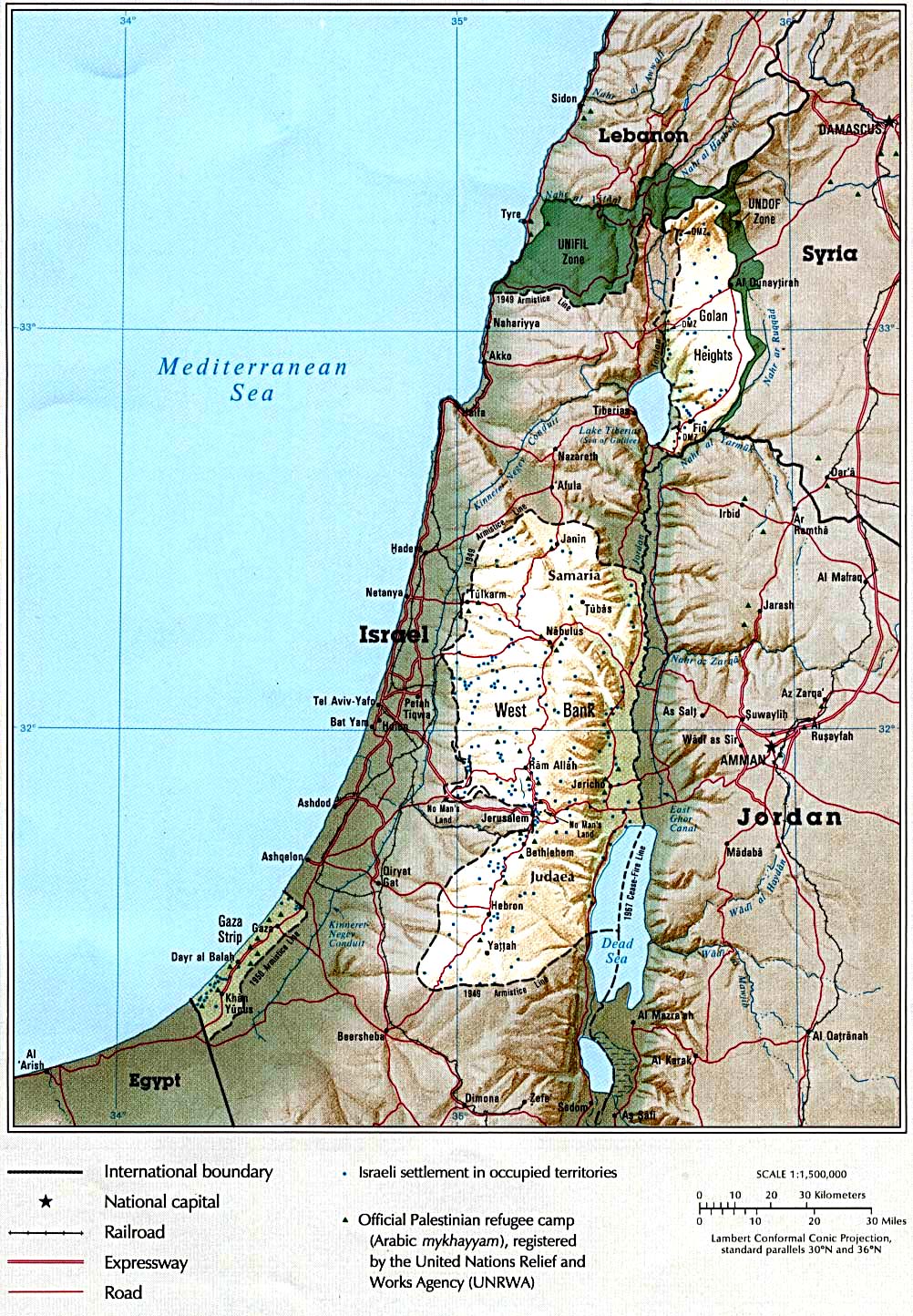
For a camp to be recognized by UNRWA, there must be an agreement between the host government and UNRWA governing use of the camp. UNRWA does not itself run any camps, has no police powers or administrative role, but simply provides services to the camp. UNRWA recognizes facilities in 58 designated refugee camps in Jordan, Lebanon, Syria, the West Bank and the Gaza Strip, and it also provides facilities in other areas where large numbers of registered Palestine refugees live outside of recognized camps. UNRWA also provided relief to Jewish displaced persons inside Israel following the 1948 conflict until the Israeli government took over responsibility for them in 1952. Refugee camps developed from tented cities to rows of concrete blockhouses to urban ghettos indistinguishable from their surroundings (effectively becoming urban developments within existing cities or by themselves), that house around one third of all registered Palestine refugees.

The Funding for UNRWA activities comes almost entirely from voluntary contributions from UN member states. UNRWA also receives some funding from the Regular Budget of the United Nations, which is used mostly for international staffing costs.[6]

List of camps

The camps are divided between five regions:

  • Gaza Strip: The Gaza Strip has eight official and no unofficial refugee camps,[2] and 1,221,110 registered refugees.
  • West Bank: The West Bank has 19 official and four unofficial refugee camps,[2] and 741,409 registered refugees.
  • Syria: Syria has nine official refugee camps and three unofficial refugee camps,[2] and 499,189 registered refugees.
  • Lebanon: There are 12 official refugee and no unofficial camps in Lebanon,[2] and 448,599 registered refugees.
  • Jordan: There are 10 official and three unofficial refugee camps in Jordan,[2] and 2,034,641 registered refugees.
NameFoundedLocationStatusCoordinatesPopulationArea (km2)Density (pop/km2)CommentsRefs
Yarmouk1957SyriaUnofficial33°28′27″N 36°18′11″E / 33.47417°N 36.30306°E / 33.47417; 36.30306n.a.2.1n.a.Largely destroyed (was 160,000 population)[7]
Rafah1949Gaza StripUNRWA31°16′58.87″N 34°15′11.52″E / 31.2830194°N 34.2532000°E / 31.2830194; 34.2532000125,304n.a.n.a.[8]
Baqa'a1968JordanUNRWA32°04′25″N 35°50′35″E / 32.07361°N 35.84306°E / 32.07361; 35.84306119,0001.485,000[9]
Jabalia1948Gaza StripUNRWA31°32′20.81″N 34°29′57.63″E / 31.5391139°N 34.4993417°E / 31.5391139; 34.4993417113,9901.481,421[10]
Khan Yunis1949Gaza StripUNRWA31°21′3″N 34°17′18″E / 31.35083°N 34.28833°E / 31.35083; 34.2883387,8160.549159,956[11][12]
Al-Shati (Beach camp)1948Gaza StripUNRWA31°31′55.91″N 34°26′43.42″E / 31.5321972°N 34.4453944°E / 31.5321972; 34.445394485,6280.52164,669[13]
Nuseirat1949Gaza StripUNRWA31°26′51.56″N 34°23′34.35″E / 31.4476556°N 34.3928750°E / 31.4476556; 34.392875080,194n.a.n.a.[14]
Ain al-Hilweh1948LebanonUNRWA33°32′37″N 35°22′41″E / 33.54361°N 35.37806°E / 33.54361; 35.3780659,6600.3198,867[15][16]
Al-Wehdat refugee camp (Amman New Camp)1955JordanUNRWA31°55′35″N 35°56′18″E / 31.92639°N 35.93833°E / 31.92639; 35.9383357,0000.48118,750[17]
Marka1968JordanUNRWA32°00′33″N 36°01′14″E / 32.00917°N 36.02056°E / 32.00917; 36.0205653,0000.9257,609[18]
Jaramana1948SyriaUNRWA33°29′N 36°21′E / 33.483°N 36.350°E / 33.483; 36.35049,0000.031,633,333[19]
Latakia1955–6SyriaUnofficial35°30′28″N 35°47′45″E / 35.50778°N 35.79583°E / 35.50778; 35.7958347,4000.22215,455[20]
Bureij1949Gaza StripUNRWA31°26′22.31″N 34°24′10.58″E / 31.4395306°N 34.4029389°E / 31.4395306; 34.402938943,3300.52981,909[21][22]
Rashidieh1963LebanonUNRWA33°14′12.12″N 35°13′5.16″E / 33.2367000°N 35.2181000°E / 33.2367000; 35.218100034,5840.25138,336[23][16]
Jabal el-Hussein1952JordanUNRWA31°57′52″N 35°54′23″E / 31.96444°N 35.90639°E / 31.96444; 35.9063932,0000.4276,190[24]
Maghazi1949Gaza StripUNRWA31°25′16.89″N 34°23′07.35″E / 31.4213583°N 34.3853750°E / 31.4213583; 34.385375031,3290.652,215[25]
Jerash1968JordanUNRWA32°16′20.21″N 35°53′29.03″E / 32.2722806°N 35.8913972°E / 32.2722806; 35.891397229,0000.7538,667[26]
Irbid1951JordanUNRWA32°33′0″N 35°51′0″E / 32.55000°N 35.85000°E / 32.55000; 35.8500028,0000.24116,667[27]
Balata1950West BankUNRWA32°12′N 35°17′E / 32.200°N 35.283°E / 32.200; 35.28327,0000.25108,000[28]
Deir al-Balah1948Gaza StripUNRWA31°25′33″N 34°20′26″E / 31.42583°N 34.34056°E / 31.42583; 34.3405625,5690.16159,806[29][30]
Husn (Martyr Azmi el-Mufti camp)1968JordanUNRWA32°28′30″N 35°54′18″E / 32.47500°N 35.90500°E / 32.47500; 35.9050025,0000.7732,468[31]
Burj el-Shemali1955LebanonUNRWA33°15′47″N 35°14′20″E / 33.26306°N 35.23889°E / 33.26306; 35.2388924,9290.134186,037[32][16]
Shu'fat camp1965West BankUNRWA31°48′44″N 35°14′47″E / 31.81222°N 35.24639°E / 31.81222; 35.2463924,0000.2120,000[33]
Qabr Essit1967SyriaUNRWA33°26′50″N 36°20′10″E / 33.44722°N 36.33611°E / 33.44722; 36.3361123,7000.021,185,000[34]
Tulkarm1950West BankUNRWA32°18′51″N 35°2′4″E / 32.31417°N 35.03444°E / 32.31417; 35.0344421,5000.18119,444[35]
Beddawi1955LebanonUNRWA34°27′0.64″N 35°52′9.17″E / 34.4501778°N 35.8692139°E / 34.4501778; 35.869213921,2520.2106,260[36][16]
Zarqa1949JordanUNRWA32°05′N 36°06′E / 32.083°N 36.100°E / 32.083; 36.10020,0000.18111,111[37]
Bourj el-Barajneh1948LebanonUNRWA33°50′54″N 35°30′12″E / 33.84833°N 35.50333°E / 33.84833; 35.5033319,5390.104187,875[38][16]
Souf1967JordanUNRWA32°18′30″N 35°53′7.37″E / 32.30833°N 35.8853806°E / 32.30833; 35.885380619,0000.538,000[39]
Askar1950West BankUNRWA32°13′11.51″N 35°17′50.77″E / 32.2198639°N 35.2974361°E / 32.2198639; 35.297436118,5000.119155,462[40]
Al-Nayrab1948SyriaUNRWA36°10′32″N 37°13′40″E / 36.17556°N 37.22778°E / 36.17556; 37.2277818,0000.15120,000[41]
Dheisheh1949West BankUNRWA31°41′38.47″N 35°11′02.96″E / 31.6940194°N 35.1841556°E / 31.6940194; 35.184155615,0000.3345,455[42]
Kalandia1949West BankUNRWA33°19′55″N 36°19′56″E / 33.33194°N 36.33222°E / 33.33194; 36.3322214,8000.4235,238[43]
Al-Hassan1967JordanUnofficial31°57′27″N 35°58′19″E / 31.95750°N 35.97194°E / 31.95750; 35.9719414,068n.a.n.a.[44][45][46]
Jenin1953West BankUNRWA32°27′41″N 35°17′11″E / 32.46139°N 35.28639°E / 32.46139; 35.2863914,0000.4233,333[47]
Jalazone1949West BankUNRWA31°57′07.15″N 35°12′41.58″E / 31.9519861°N 35.2115500°E / 31.9519861; 35.211550013,0000.25351,383[48]
Al-Sabinah1948SyriaUNRWA33°26′2″N 36°17′8″E / 33.43389°N 36.28556°E / 33.43389; 36.2855613,0000.03433,333[49]
Homs1949SyriaUNRWA34°42′30.29″N 36°42′26.62″E / 34.7084139°N 36.7073944°E / 34.7084139; 36.707394413,0000.1586,667[50]
Khan Danoun1950SyriaUNRWA33°19′55″N 36°19′56″E / 33.33194°N 36.33222°E / 33.33194; 36.3322212,6500.03421,667[51]
El Buss1948LebanonUNRWA33°16′21″N 35°12′36″E / 33.27250°N 35.21000°E / 33.27250; 35.2100012,2810.08153,513[52][16]
Al-Arroub1950West BankUNRWA31°37′23.18″N 35°08′12.19″E / 31.6231056°N 35.1367194°E / 31.6231056; 35.136719412,0000.2450,000[53]
Khan al-Shih1949SyriaUNRWA33°21′30″N 36°6′26″E / 33.35833°N 36.10722°E / 33.35833; 36.1072212,0000.6917,391[54]
Shatila1949LebanonUNRWA33°51′46″N 35°29′54″E / 33.86278°N 35.49833°E / 33.86278; 35.4983310,8490.04271,225[55][16]
Nur Shams1952West BankUNRWA32°19′07.36″N 35°03′31.63″E / 32.3187111°N 35.0587861°E / 32.3187111; 35.058786110,5000.2150,000[56]
Daraa1950SyriaUNRWA32°37′N 36°6′E / 32.617°N 36.100°E / 32.617; 36.10010,5001.38,077[57]
Fawwar1949West BankUNRWA31°28′46.45″N 35°03′52.93″E / 31.4795694°N 35.0647028°E / 31.4795694; 35.06470289,5000.2735,185[58]
Wavel1948LebanonUNRWA33°59′56.27″N 36°11′35.46″E / 33.9989639°N 36.1931833°E / 33.9989639; 36.19318339,4600.043220,000[59][16]
Hama1950SyriaUNRWA35°08′N 36°45′E / 35.133°N 36.750°E / 35.133; 36.7509,0000.06150,000[60]
Aqabat Jaber1948West BankUNRWA31°50′17.00″N 35°26′30.20″E / 31.8380556°N 35.4417222°E / 31.8380556; 35.44172228,6001.675,150[61]
Madaba camp1956JordanUnofficial31°42′41″N 35°47′15″E / 31.71139°N 35.78750°E / 31.71139; 35.787508,597n.a.n.a.[44]
Far'a1949West BankUNRWA32°17′38.35″N 35°20′39.74″E / 32.2939861°N 35.3443722°E / 32.2939861; 35.34437228,5000.2632,692[62]
Talbieh Camp1968JordanUNRWA31°42′19″N 35°56′57″E / 31.70528°N 35.94917°E / 31.70528; 35.949178,0000.1361,538[63]
Ein Beit al-Ma' (Camp No. 1)1950West BankUNRWA32°13′48.91″N 35°14′58.42″E / 32.2302528°N 35.2495611°E / 32.2302528; 35.24956117,5000.045166,667[64]
Sokhna camp1969JordanUnofficial32°7′59″N 36°4′20″E / 32.13306°N 36.07222°E / 32.13306; 36.072227,424n.a.n.a.sometimes transliterated 'Sakhna' or 'Sukhna'[44]
Am'ari1949West BankUNRWA31°53′38.60″N 35°12′41.52″E / 31.8940556°N 35.2115333°E / 31.8940556; 35.21153337,0000.09672,917[65]
Ein Al-Tal (also known as Handarat camp)1962SyriaUnofficial36°17′34.84″N 37°9′24.86″E / 36.2930111°N 37.1569056°E / 36.2930111; 37.1569056n.a.0.16n.a.Largely destroyed (was 7,000 population)[66]
Nahr al-Bared1949LebanonUNRWA34°30′47″N 35°57′40″E / 34.51306°N 35.96111°E / 34.51306; 35.961115,8570.19829,581Reconstructed, was 27,000 population[67][16]
Mieh Mieh1954LebanonUNRWA33°32′30″N 35°23′29″E / 33.54167°N 35.39139°E / 33.54167; 35.391395,7470.054106,426[68][16]
Aida1950West BankUNRWA31°43′10.34″N 35°11′56.31″E / 31.7195389°N 35.1989750°E / 31.7195389; 35.19897505,5000.07177,465[69]
Dbayeh1956LebanonUNRWA33°54′N 35°34′E / 33.900°N 35.567°E / 33.900; 35.5674,5910.08454,655[70][16]
Ein as-Sultan camp1948West BankUNRWA31°52′40.24″N 35°26′46.24″E / 31.8778444°N 35.4461778°E / 31.8778444; 35.44617783,8000.874,368[71]
'Azza (Beit Jibrin)1950West BankUNRWA31°42′54.78″N 35°12′07.61″E / 31.7152167°N 35.2021139°E / 31.7152167; 35.20211392,9000.027107,407[72]
Deir 'Ammar Camp1949West BankUNRWA31°57′57.22″N 35°05′55.98″E / 31.9658944°N 35.0988833°E / 31.9658944; 35.09888332,5000.16215,432[73]
Qaddura camp1948West BankUnofficial31°54′3.32″N 35°12′21.18″E / 31.9009222°N 35.2058833°E / 31.9009222; 35.20588331,558n.a.n.a.[74]
Mar Elias refugee camp1952LebanonUNRWA33°52′38″N 35°29′19″E / 33.87722°N 35.48861°E / 33.87722; 35.488617250.0054134,259[75][16]
Silwad Camp1971West BankUnofficial31°58′5″N 35°15′41″E / 31.96806°N 35.26139°E / 31.96806; 35.26139462n.a.n.a.[44]
Abu Shukheidim camp1948West BankUnofficialn.a.n.a.n.a.Town of Abu Shukhaydam (sic) shows on maps as ~1mi SW of Birzeit[44]
Birzeit camp (As-Saqaeif)1948West BankUnofficial31°58′12″N 35°12′01″E / 31.97000°N 35.20028°E / 31.97000; 35.20028n.a.n.a.n.a.[44][76]

Population statistics

The evolution of Palestinian refugee population is shown below:[77][4]

195019601970198019902000200420092018
Jordan506,200613,743506,038716,372929,0971,570,1921,758,2741,951,6032,242,579
Lebanon127,600136,561175,958226,554302,049376,472396,890422,188475,075
Syria82,194115,043158,717209,362280,731383,199417,346461,897560,139
West Bank272,692324,035414,298583,009675,670762,820846,465
Gaza Strip198,227255,542311,814367,995496,339824,622938,5311,073,3031,421,282
Total registered refugees914,2211,120,8891,425,2191,844,3182,422,5143,737,4944,186,7114,671,8115,545,540

The number of Palestinian refugees living within the UNWRA registered area of operations is shown below, both those living in camps and those living outside camps:[3][4][78]

Registered persons (refugees and other)Registered refugees in camps% registered refugees in camps
1953870,158300,78534.6
1955912,425351,53238.5
19601,136,487409,22336.0
19651,300,117508,04239.1
19701,445,022500,98534.7
19751,652,436551,64333.4
19801,863,162613,14932.9
19852,119,862805,48238.0
19902,466,516697,70928.3
19953,246,0441,007,37531.0
20003,806,0551,227,95432.3
20054,283,8921,265,98729.6
20104,966,6641,452,79029.3
20155,741,4801,632,87628.4
20186,171,7931,728,40928.0

The table below shows the population of registered refugees, other registered people, and refugees residing in camps, in 2018.[79] UNRWA's definition of Other Registered Persons refer to "those who, at the time of original registration did not satisfy all of UNRWA's Palestine refugee criteria, but who were determined to have suffered significant loss and/or hardship for reasons related to the 1948 conflict in Palestine; they also include persons who belong to the families of other registered persons."[80]

JordanLebanonSyriaWest BankGaza StripTotal
Registered refugees2,242,579475,075560,139846,4651,421,2825,545,540
Other registered people133,90258,81083,003201,525149,013626,253
Total registered people2,376,481533,885643,1421,047,9901,570,2956,171,793
Refugees living within official camp borders412,054270,614194,993256,758593,9901,728,409
% living within camp borders18.4%57.0%34.8%30.3%41.8%31.2%

See also

References

Bibliography

External links

Maps