Selected article

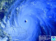
Typhoon Tip was the largest and most intense tropical cyclone on record. The nineteenth tropical storm, twelfth typhoon, and third super typhoon of the 1979 Pacific typhoon season, Tip developed out of a disturbance in the monsoon trough on October 4, near Pohnpei. Initially, a tropical storm to its northwest hindered the development and motion of Tip, though after it tracked further north Tip was able to intensify. After passing Guam, it rapidly intensified and reached peak winds of 305 km/h (190 mph) and a worldwide record low pressure of 870 mbar (hPa) on October 12. At its peak strength, it was also the largest tropical cyclone on record with a diameter of 2220 km (1380 mi). It slowly weakened as it continued west-northwestward, and later turned to the northeast under the influence of an approaching trough. Tip made landfall on southern Japan on October 19, and became an extratropical cyclone shortly thereafter.
Air Force Reconnaissance flew into the typhoon for 60 missions, making Tip one of the most closely observed tropical cyclones of all time. Rainfall from the typhoon breached a flood-retaining wall at a United States Marine Corps training camp in the Kanagawa Prefecture of Japan, leading to a fire which injured 68 and killed 13 marines. Elsewhere in the country, it led to widespread flooding and 42 deaths. 44 were killed or left unaccounted for due to shipwrecks offshore.
Recently featured: Tropical cyclogenesis – List of Florida hurricanes (pre-1900) – Hurricane Erika (1997) – 2000 Sri Lanka cyclone – Hurricane Ismael – BrowsePortal:Tropical cyclones/Selected article/2
Hurricane Katrina was the costliest (tied with Hurricane Harvey) and one of the deadliest hurricanes in the history of the United States. It was the eleventh named storm, fifth hurricane, third major hurricane, and second Category 5 hurricane of the 2005 Atlantic hurricane season, and was the seventh-strongest Atlantic hurricane ever recorded.
Katrina formed over the Bahamas on August 23, 2005, and crossed southern Florida as a moderate Category 1 hurricane before strengthening rapidly in the Gulf of Mexico and becoming one of the strongest hurricanes ever recorded in the Gulf. The storm weakened considerably before making its second landfall as a Category 3 storm on the morning of August 29 in southeast Louisiana.
It is possible that Katrina was the largest hurricane of its strength to approach the United States in recorded history; its sheer size caused devastation over 100 miles from the center. The storm surge caused major or catastrophic damage along the coastlines of Louisiana, Mississippi, and Alabama, including the cities of Mobile, Alabama, Biloxi and Gulfport, Mississippi, and Slidell, Louisiana. Levees separating Lake Pontchartrain from New Orleans, Louisiana were breached by the surge, ultimately flooding roughly 80% of the city and many areas of neighboring parishes. Severe wind damage was reported well inland. Katrina is estimated to be responsible for $125 billion (2005 US dollars) in damages, making it the costliest hurricane in U.S. history. The storm killed at least 1,836 people, making it the deadliest U.S. hurricane since the 1928 Okeechobee Hurricane.
Recently featured: List of storms in the 2005 Atlantic hurricane season – List of New Jersey hurricanes – Hurricane Claudette (2003) – Browse
Portal:Tropical cyclones/Selected article/3
In meteorology, a tropical cyclone is a storm system with a spiral arrangement of thunderstorms, and a closed circulation around a center of low pressure, fueled by the heat released when moist air rises and condenses. The name underscores their origin in the tropics and their cyclonic nature. They are distinguished from other cyclonic storms such as nor'easters and polar lows by the heat mechanism that fuels them, which makes them "warm core" storm systems.
Depending on their strength and location, there are various terms by which tropical cyclones can be described, such as tropical depression, tropical storm, hurricane, and typhoon.
Tropical cyclones can produce extremely high winds, tornadoes, torrential rain (leading to mudslides and flash floods), and drive storm surge onto coastal areas. Though the effects on populations and ships can be catastrophic, tropical cyclones have been known to relieve drought conditions. They also carry heat away from the tropics, an important mechanism of the global atmospheric circulation that maintains equilibrium in the environment.
Recently featured: Cyclone Percy – 2005 Atlantic hurricane season – Hurricane Katrina – List of storms in the 2005 Atlantic hurricane season – Browse
Portal:Tropical cyclones/Selected article/4

A storm surge is an offshore rise of water associated with a low pressure weather system, typically a tropical cyclone. Storm surge is caused primarily by high winds pushing on the ocean's surface. The wind causes the water to pile up higher than the ordinary sea level. Low pressure at the center of a weather system also has a small secondary effect, as can the bathymetry of the body of water. It is this combined effect of low pressure and persistent wind over a shallow water body which is the most common cause of storm surge flooding problems. The term "storm surge" in casual (non-scientific) use is storm tide; that is, it refers to the rise of water associated with the storm, plus tide, wave run-up, and freshwater flooding. When referencing storm surge height, it is important to clarify the usage, as well as the reference point. NHC tropical storm reports reference storm surge as water height above predicted astronomical tide level, and storm tide as water height above NGVD-29.
In areas where there is a significant difference between low tide and high tide, storm surges are particularly damaging when they occur at the time of a high tide. In these cases, this increases the difficulty of predicting the magnitude of a storm surge since it requires weather forecasts to be accurate to within a few hours. Storm surges can be produced by non-tropical storms, such as the "Halloween Storm" of 1991 and the Storm of the Century (1993), but the most extreme storm surge events occur as a result of extreme weather systems, such as tropical cyclones. Factors that determine the surge heights for landfalling tropical cyclones include the speed, intensity, size of the radius of maximum winds (RMW), radius of the wind fields, angle of the track relative to the coastline, the physical characteristics of the coastline and the bathymetry of the water offshore. The SLOSH (Sea, Lake, and Overland Surges from Hurricanes) model is used to simulate surge from tropical cyclones.
Recently featured: List of Florida hurricanes (1900-1949) – Meteorological history of Hurricane Ivan – Hurricane Ioke – Hurricane Dog (1950) – 2007 Pacific hurricane season – BrowsePortal:Tropical cyclones/Selected article/5

Tropical Storm Barry was a strong tropical storm that made landfall on the Florida Panhandle during August 2001. The third tropical cyclone and second named storm of the 2001 Atlantic hurricane season, Barry developed from a tropical wave that moved off the coast of Africa on July 24 and tracked westward. The wave entered the Caribbean on July 29 and spawned a low-pressure area that organized into Tropical Storm Barry on August 3. After fluctuations in intensity and track, the system attained peak winds of 70 mph (110 km/h) in the Gulf of Mexico, and headed northward before moving ashore on the Gulf Coast.
Unlike the devastating Tropical Storm Allison earlier in the season, Barry's effects were moderate. Nine deaths occurred, six in Cuba and three in Florida. As a tropical cyclone, rainfall peaked at 8.9 in (230 mm) at Tallahassee, and winds gusts topped out at 79 mph (127 km/h). The wave that would become Barry dropped large amounts of rain across southern Florida, which led to significant flooding and structural damage. Moderate flooding occurred throughout the Panhandle, where damage was also reported as a result of high wind gusts. As the storm's remnants tracked inland, parts of the Mississippi Valley received light precipitation. Barry is estimated to have caused $30 million (2001 USD, $36.5 million 2008 USD) in damage.
Recently featured: 1988 Pacific hurricane season — Effects of Hurricane Charley in South Carolina — Tropical Storm Zeta — List of North Carolina hurricanes (1950–1979) — Hurricane Lili (1984) — BrowsePortal:Tropical cyclones/Selected article/6

Hurricane Isabel was the costliest and deadliest hurricane in the 2003 Atlantic hurricane season. The ninth tropical storm, fifth hurricane, and second major hurricane of the season, Isabel formed from a tropical wave on September 6 in the tropical Atlantic Ocean. Isabel moved northwestward, and within an environment of light wind shear and warm waters, it steadily strengthened to reach peak winds of 165 mph (265 km/h) on September 11, and acquired annular characteristics around this time. After fluctuating in intensity for four days, Isabel gradually weakened and made landfall on the Outer Banks of North Carolina with winds of 105 mph (165 km/h) on September 18. It quickly weakened over land and became extratropical over western Pennsylvania on the next day, before being absorbed into another system on September 20.
In North Carolina, the storm surge from Isabel washed out a portion of Hatteras Island to form what was unofficially known as Isabel Inlet. Damage was greatest along the Outer Banks, where thousands of homes were damaged or destroyed. The worst of the effects of Isabel occurred in the state of Virginia, which reported the most deaths and damage from the hurricane. About 64% of the damage and 68% of the deaths occurred in the two states alone.
Moderate to severe damage extended up the Atlantic Coastline and as far inland as West Virginia. Roughly 6 million were left without power in the eastern United States from the strong winds of Isabel. Rainfall from the storm extended from South Carolina to Maine, and westward to Michigan. Throughout the path of Isabel, damage totaled about $3.6 billion (2003 USD, $4.87 billion 2018 USD). 16 deaths in seven states were directly related to the hurricane, with 35 deaths in six states and one province indirectly related to the hurricane.
Recently featured: Hurricane Iwa — Tropical Storm Bilis – Hurricane Pauline – Effects of Hurricane Isabel in Maryland and Washington, D.C. – Hurricane Juan – BrowsePortal:Tropical cyclones/Selected article/7

Hurricane Fabian was a powerful Cape Verde-type hurricane that hit Bermuda in early September during the 2003 Atlantic hurricane season. Fabian, the sixth named storm, fourth hurricane, and first major hurricane of the season, developed from a tropical wave in the tropical Atlantic Ocean on August 25. It moved west-northwestward under the influence of the subtropical ridge to its north, and steadily strengthened in an area of warm water temperatures and light wind shear. The hurricane attained a peak intensity of 145 mph (230 km/h) on September 1, and it slowly weakened as it turned northward. On September 5, Fabian made a direct hit on the island of Bermuda with wind speeds of over 120 mph (195 km/h). After passing the island, the hurricane turned to the northeast, and became extratropical on September 8.
Fabian was the strongest hurricane to hit Bermuda since Hurricane Arlene in 1963. It was both the most damaging and the first hurricane to cause a death on the island since 1926. The hurricane's powerful winds resulted in moderate damage and destroyed roofs throughout the island. A strong storm surge associated with the hurricane killed four people crossing a causeway on Bermuda, temporarily closing the only link between two islands. The endangered Bermuda Petrel was threatened by the hurricane, which destroyed ten nests, although volunteer work transported the species to a safer location. Strong swells resulted in damage in northern Puerto Rico and the Dominican Republic, and also caused four people to drown along the United States' Atlantic coast. In all, Fabian caused around $300 million (2003 USD) in damage and eight deaths.
Portal:Tropical cyclones/Selected article/8
Hurricane Mitch was one of the most powerful Atlantic hurricanes ever observed, with maximum sustained winds of 180 mph (290 km/h). The storm was the thirteenth tropical storm, ninth hurricane, and third major hurricane of the 1998 Atlantic hurricane season. At the time, Mitch was the strongest hurricane ever observed in the Atlantic Ocean in the month of October, though it has since been surpassed by Hurricane Wilma of the 2005 season. Mitch formed in the western Caribbean Sea, eventually reaching Category 5 status on the Saffir–Simpson Hurricane Scale (SSHS). It remained nearly stationary over water for several days before eventually weakening, striking Honduras as a minimal hurricane.
Though Mitch weakened before striking land, it drifted just off the coast of Central America from October 29 to November 3, dropping historic amounts of rainfall, with unofficial reports of up to 75 inches (1,900 mm). Deaths due to catastrophic flooding made it the second deadliest Atlantic hurricane in history; nearly 11,000 people were killed with over 8,000 left missing by the end of 1998. The flooding caused extreme damage, amounting to around $7 billion (2005 USD), though exact totals will likely never be known.
Recently featured: Hurricane Nora (1997) – Hurricane Claudette (2003) – List of Category 5 Atlantic hurricanes – Browse
Portal:Tropical cyclones/Selected article/9
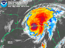
Hurricane Georges was the seventh tropical storm, fourth hurricane, and second major hurricane of the 1998 Atlantic hurricane season. The tropical cyclone made seven landfalls on its long track through the Caribbean Sea and Gulf of Mexico during September, becoming the second most destructive storm of the season. Georges killed 603 people, mainly on the island of Hispaniola, and caused nearly $6 billion (1998 US dollars) in damages, mostly in Puerto Rico and Hispaniola. The hurricane affected at least six different countries (Antigua, St. Kitts and Nevis, Haiti, Dominican Republic, Cuba, United States) — more than any other hurricane in years, and more than any other hurricane since until Hurricane Wilma in the 2005 season affected ten different countries.
Recently featured: Cyclone Tracy – Hurricane Gordon – Hurricane Floyd – Browse
Portal:Tropical cyclones/Selected article/10

The 1933 Atlantic hurricane season is the second most active Atlantic hurricane season on record, with 21 storms forming during that year. The season, which began on June 1, 1933 and lasted until November 30, 1933, is surpassed only by the 2005 season, which broke the record with its 28 storms. The 1933 season saw tropical activity before its start, and a tropical cyclone was active for all but 13 days from June 28 to October 7. Tropical cyclones that did not approach populated areas or shipping lanes, especially if they were relatively weak and of short duration, may have remained undetected. Because technologies such as satellite monitoring were not available until the 1960s, historical data on tropical cyclones from this period are often not reliable.
Ten of the season's 21 storms attained hurricane status. Five of those were major hurricanes, with sustained winds of over 111 mph (179 km/h); the strongest reached peak winds of 150 mph (240 km/h) near the Bahamas in early October. The season produced several deadly storms, with eight storms killing more than 20 people. All but one of the 21 known storms affected land at some point during their lifetimes.
Recently featured: Hurricane Edith (1971) – 1995 Pacific hurricane season – Hurricane Erika (2003) – Effects of Hurricane Isabel in North Carolina – Tropical Storm Edouard (2002) – List of retired Pacific hurricane names – BrowsePortal:Tropical cyclones/Selected article/11
The 2005 Atlantic hurricane season was the most active Atlantic hurricane season in recorded history, shattering previous records on repeated occasions. The impact of the season was widespread and ruinous with at least 2,048 deaths and record damages of over $100 billion USD, with the damage surpassed only by the 2017 season. The season's five landfalling major hurricanes—Dennis, Emily, Katrina, Rita, and Wilma—were responsible for most of the destruction. The Mexican state of Quintana Roo and the U.S. states of Florida and Louisiana were each struck twice by major hurricanes; Cuba, Mississippi, Texas, and Tamaulipas were each struck once and in each case brushed by at least one more. The most catastrophic effects of the season were felt on the United States' Gulf Coast, where a 30-foot storm surge from Hurricane Katrina caused devastating flooding that inundated New Orleans and destroyed most structures on the Mississippi coastline, and in Guatemala, where Hurricane Stan combined with an extratropical system to cause extremely deadly mudslides.
The season officially began on June 1, 2005, and lasted until November 30, 2005, although effectively the season persisted into January 2006 due to continued storm activity. A record twenty-eight tropical and subtropical storms formed, of which a record fifteen became hurricanes. Of these, seven strengthened into major hurricanes, a record-tying five became Category 4 hurricanes and a record four reached Category 5 strength, the highest categorization for hurricanes on the Saffir–Simpson hurricane scale. Among these Category 5 storms was Hurricane Wilma, the most intense hurricane ever observed in the Atlantic.
Recently featured: Hurricane Katrina – List of storms in the 2005 Atlantic hurricane season – List of New Jersey hurricanes – Hurricane Claudette (2003) – Browse
Portal:Tropical cyclones/Selected article/12

The Great Hurricane of 1780, also known as the Hurricane San Calixto II, is the deadliest Atlantic hurricane on record. Over 22,000 people people died when the storm passed through the Lesser Antilles in the Caribbean between October 10 and October 16. The beginning of the official Atlantic hurricane database is in 1851; thus, specifics on its track and strength are unknown.
The hurricane struck Barbados with winds possibly exceeding 200 mph (320 km/h), before moving past Martinique, Saint Lucia, and Sint Eustatius; thousands of deaths were reported on each island. Coming in the midst of the American Revolution, the storm caused heavy losses to British and French fleets contesting for control of the area. The hurricane later passed near Puerto Rico and over the eastern portion of the Dominican Republic, causing heavy damage near the coastlines and ultimately turned to the northeast before being last observed on October 20 southeast of Cape Race, Newfoundland.
The death toll from the Great Hurricane alone exceeds that for any other entire decade of Atlantic hurricanes, and is substantially higher than that of the second-deadliest Atlantic storm, Hurricane Mitch. The hurricane was part of the disastrous 1780 Atlantic hurricane season, with three other deadly storms occurring in the month of October.
Portal:Tropical cyclones/Selected article/13
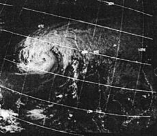
The 1970 Bhola cyclone was a devastating tropical cyclone that struck East Pakistan (now Bangladesh) on November 12, 1970. It was the deadliest tropical cyclone ever recorded, and one of the deadliest natural disasters of modern times. At least 500,000 people lost their lives in the storm, mostly as a result of the storm surge that flooded many of the low-lying islands of the Ganges Delta. This cyclone was the sixth cyclonic storm of the 1970 North Indian Ocean cyclone season and was also the most powerful, reaching a strength equivalent to a Category 4 hurricane.
The cyclone formed over the central Bay of Bengal on November 8 and moved north, intensifying as it did so. It reached its peak with winds of 185 km/h (115 mph) on November 12 and made landfall on the East Pakistan coast that night. The storm surge devastated many of the offshore islands, wiping out villages and destroying crops throughout the region. In the most severely affected Thana, Tazumuddin, over 45% of the population of 167,000 was killed by the storm.
The Pakistani government was severely criticised for its handling of the relief operations following the storm, both by local political leaders in East Pakistan and in the international media. The opposition Awami League gained a landslide victory in the province and continuing unrest between East Pakistan and the central government trigged the Bangladesh Liberation War, which concluded with the creation of the state of Bangladesh.
Portal:Tropical cyclones/Selected article/14

Hurricane Pauline was one of the strongest and deadliest Pacific hurricanes to make landfall on Mexico. The 16th tropical storm, 8th hurricane, and 7th major hurricane of the 1997 Pacific hurricane season, Pauline developed out of a tropical wave on October 5 about 250 miles (410 km) south-southwest of Huatulco in the state of Oaxaca. It initially moved eastward, then turned northwestward and quickly strengthened to reach peak winds of 135 mph. It paralleled the Mexican coastline a short distance offshore before weakening and hitting Puerto Escondido on October 9, and dissipated the next day.
Pauline produced torrential rainfall along the Mexican coastline, peaking at 16 inches in Acapulco. Intense flooding and mudslides in some of the poorest areas of Mexico killed between 230 to 400 people, making it one of the deadliest Eastern Pacific storms in recorded history. The passage of the hurricane destroyed or damaged tens of thousands of houses, leaving around 300,000 homeless and causing $7.5 billion in damage (1997 USD, 80 million 1997 MXN pesos, $9.3 billion (2006 USD).
Recently featured: Effects of Hurricane Isabel in Maryland and Washington, D.C. – Hurricane Juan – List of Baja California Peninsula hurricanes – Hurricane Gustav (2002) – Effects of Hurricane Isabel in Delaware – BrowsePortal:Tropical cyclones/Selected article/15
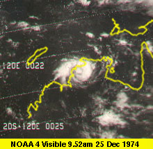
Cyclone Tracy was a tropical cyclone that devastated Darwin, Australia, from December 24 to December 25, 1974. It was recorded by The Age as being a "disaster of the first magnitude...without parallel in Australia's history." It killed 71 people - the official death toll was revised upwards from 65 to 71 in March 2005 - and destroyed over 70 percent of Darwin's buildings, leaving over 20,000 people homeless. Most of Darwin's population was evacuated to Adelaide, Whyalla, Alice Springs and Sydney, and many never returned to Darwin. The town was subsequently rebuilt with modern materials and techniques. Cyclone Tracy was at least a Category 4 storm, although there is evidence to suggest that it had reached Category 5 intensity when it made landfall at Darwin.
Recently featured: Hurricane Gordon – Hurricane Floyd – 1928 Okeechobee hurricane – Browse
Portal:Tropical cyclones/Selected article/16
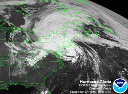
Hurricane Gloria was a hurricane during the 1985 Atlantic hurricane season that prowled the Atlantic Ocean from September 16 to September 28, 1985. A Cape Verde-type hurricane, it reached Category 4 intensity on the Saffir–Simpson Hurricane Scale, but weakened significantly by the time it made landfall on North Carolina and on Long Island. Gloria caused extensive damage in the East Coast of the United States, amounting to $1.6 billion (2005 USD), and was responsible for 11 fatalities.
Recently featured: Hurricane Iniki – Hurricane Georges – Cyclone Tracy – Browse
Portal:Tropical cyclones/Selected article/17

Hurricane Gilbert was an extremely powerful Cape Verde hurricane that formed during the 1988 Atlantic hurricane season and wrought widespread destruction in the Caribbean Sea and the Gulf of Mexico. It is the second most intense hurricane ever observed in the Atlantic basin behind only Hurricane Wilma of the extremely active 2005 Atlantic hurricane season. Gilbert was also one of the largest tropical cyclones ever observed in the Atlantic basin. At one point, its tropical storm-force winds measured 588 mi (946 km) in diameter. In addition, Gilbert was the most intense tropical cyclone in recorded history to strike Mexico.
The seventh named storm and third hurricane of the 1988 Atlantic hurricane season, Gilbert developed from a tropical wave on September 8 while located 400 mi (640 km) east of Barbados. Following intensification into a tropical storm the next day, Gilbert steadily strengthened as it tracked west-northwestward into the Caribbean Sea. On September 10, Gilbert attained hurricane intensity, and rapidly intensified into a Category 3 hurricane on September 11. After striking Jamaica the following day, rapid intensification occurred once again, and the storm became a Category 5 hurricane on the Saffir–Simpson hurricane scale late on September 13. Gilbert weakened slightly, and made landfall on the Yucatán Peninsula later that day while maintaining Category 5 intensity. After landfall, Gilbert weakened rapidly over the Yucatán Peninsula, and emerged into the Gulf of Mexico as a Category 2 on September 15. Gradual intensification occurred as Gilbert tracked across the Gulf of Mexico, and the storm made landfall as a Category 4 hurricane in mainland Mexico on September 16. The hurricane gradually weakened after landfall, and eventually dissipated on September 19 over the Midwestern United States. Gilbert inflicted $7.1 billion in damage.
Recently featured: Hurricane Floyd – Hurricane Georges – browse
Portal:Tropical cyclones/Selected article/18

Hurricane Floyd was the sixth named storm, fourth hurricane, and third major hurricane in the 1999 Atlantic hurricane season. A Cape Verde-type hurricane, it struck the Bahamas and paralleled the coastline of the Eastern United States, making landfall in North Carolina as a Category 2 hurricane. The hurricane produced torrential rainfall in the state, adding more rain to an area hit by Hurricane Dennis just weeks earlier. Floyd was responsible for 57 fatalities and $5.13 billion in damage (2005 USD).
Recently featured: 1928 Okeechobee Hurricane – Hurricane Ivan – Galveston Hurricane of 1900 – Browse
Portal:Tropical cyclones/Selected article/19

Typhoon Ketsana, known in the Philippines as Tropical Storm Ondoy, was the second most devastating tropical cyclone in the 2009 Pacific typhoon season with a damage of $1.09 billion and 747 fatalities, only behind Morakot earlier in the season, which caused 789 deaths and damages worth $6.2 billion. The storm was the sixteenth tropical storm, eighth typhoon and the second major typhoon in the season. It was the most devastating typhoon to hit Manila,[1] surpassing Typhoon Patsy (Yoling) in 1970.
Portal:Tropical cyclones/Selected article/20

The meteorological history of Hurricane Wilma, the most intense known tropical cyclone in the Western Hemisphere at the time, began in the second week of October 2005. A large area of disturbed weather developed across much of the Caribbean and gradually organized to the southeast of Jamaica. By late on October 15, the system was sufficiently organized for the National Hurricane Center to designate it as Tropical Depression Twenty-Four.
The depression drifted southwestward, and under favorable conditions, it strengthened into Tropical Storm Wilma on October 17. Initially, development was slow due to its large size, though convection steadily organized. From October 18, and through the following day, Wilma underwent explosive deepening over the open waters of the Caribbean; in a 30-hour period, the system's central atmospheric pressure dropped from 982 mbar (29.00 inHg) to the record-low value of 882 mbar (26.05 inHg), while the winds increased to 185 mph (300 km/h). At its peak intensity, the pinhole eye of Wilma was about 3 miles (5 km) in diameter, the smallest known eye in an Atlantic hurricane. After the inner eye dissipated due to an eyewall replacement cycle, Wilma weakened to Category 4 status, and on October 21, it made landfall on Cozumel and on the Mexican mainland with winds of about 150 mph (240 km/h).
Wilma weakened over the Yucatán Peninsula, and reached the southern Gulf of Mexico before accelerating northeastward. Despite increasing amounts of wind shear, the hurricane re-strengthened to hit Cape Romano, Florida as a major hurricane. Wilma weakened as it quickly crossed the state, and entered the Atlantic Ocean near Jupiter, Florida. The hurricane again re-intensified before cold air and wind shear penetrated the inner core of convection. On October 26, it transitioned into an extratropical cyclone, and the next day, the remnants of Wilma were absorbed by another extratropical storm over Atlantic Canada.
Recently featured: Hurricane Kenna — Hurricane Isabel — Hurricane Iwa — Tropical Storm Bilis – Hurricane Pauline – BrowsePortal:Tropical cyclones/Selected article/21

Hurricane Ivan was the ninth named storm, the sixth hurricane, the fourth major hurricane, and the strongest hurricane of the 2004 Atlantic hurricane season. It formed as a Cape Verde-type hurricane in early September. Ivan reached Category 5 strength on the Saffir-Simpson Hurricane Scale, the highest possible category, becoming the ninth most intense Atlantic hurricane on record and the only Category 5 storm of the season.
Ivan caused catastrophic damage to Grenada, which it struck directly at Category 3 intensity, and heavy damage to Jamaica, Grand Cayman, and the western tip of Cuba. After peaking in strength, it tracked north-northwest across the Gulf of Mexico to make landfall as a strong Category 3 storm in the U.S. near Gulf Shores, Alabama, causing very heavy damage. Ivan dropped heavy rains on the Southeastern United States as it looped across Florida and back into the Gulf of Mexico. The remnant low from the storm regenerated into a new tropical system, which moved into Louisiana and Texas, causing minimal damage. Ivan caused an estimated $20.5 billion (2004 USD) worth of damage in the United States, making it the second-costliest hurricane to strike the U.S. at the time (currently the tenth-costliest U.S. hurricane).
Recently featured: Galveston Hurricane of 1900 – Hurricane Charley – 1997 Pacific hurricane season – Browse
Portal:Tropical cyclones/Selected article/22
Hurricane Mitch was one of the most powerful Atlantic hurricanes ever observed, with maximum sustained winds of 180 mph (290 km/h). The storm was the thirteenth tropical storm, ninth hurricane, and third major hurricane of the 1998 Atlantic hurricane season. At the time, Mitch was the strongest hurricane ever observed in the Atlantic Ocean in the month of October, though it has since been surpassed by Hurricane Wilma of the 2005 season. Mitch formed in the western Caribbean Sea, eventually reaching Category 5 status on the Saffir–Simpson Hurricane Scale (SSHS). It remained nearly stationary over water for several days before eventually weakening, striking Honduras as a minimal hurricane.
Though Mitch weakened before striking land, it drifted just off the coast of Central America from October 29 to November 3, dropping historic amounts of rainfall, with unofficial reports of up to 75 inches (1,900 mm). Deaths due to catastrophic flooding made it the second deadliest Atlantic hurricane in history; nearly 11,000 people were killed with over 8,000 left missing by the end of 1998. The flooding caused extreme damage, amounting to around $7 billion (2005 USD), though exact totals will likely never be known.
Recently featured: Hurricane Nora (1997) – Hurricane Claudette (2003) – List of Category 5 Atlantic hurricanes – Browse
Portal:Tropical cyclones/Selected article/23

Typhoon Paka (international designation: 9728, JTWC designation: 05C, PAGASA designation: Rubing, also known as Super Typhoon Paka) was the last tropical cyclone in the 1997 Pacific hurricane and typhoon season, and was among the strongest Pacific typhoons in the month of December. Paka, which is the Hawaiian name for Pat, developed on November 28 in the central Pacific Ocean from a trough near the equator well to the southwest of Hawaii. After initially tracking northward, the storm turned to the west due to a strong high pressure area to its north, and on December 7 it crossed into the western Pacific Ocean. The cyclone intensified into a typhoon as it crossed the Marshall Islands on December 10, and continuing to intensify Paka struck Guam and Rota on December 16 with winds of 230 km/h (145 mph). The typhoon strengthened further and reached its peak intensity by December 18 over open waters. Subsequently it underwent a steady weakening trend, and on December 23 Paka dissipated.
Typhoon Paka first impacted the Marshall Islands, where it dropped heavy rainfall and resulted in $80 million in damage (1997 USD, $100 million 2007 USD). Later, it passed just north of Guam, where strong winds destroyed about 1,500 buildings and damaged 10,000 more; 5,000 people were left homeless, and the island experienced a complete power outage following the typhoon. Damage on the island totaled $500 million (1997 USD, $645 million 2007 USD), which warranted the retirement of its name. Paka also caused light damage in the Northern Marianas Islands. The typhoon resulted in no fatalities.
Recently featured: 1996 Pacific hurricane season – Hurricane Audrey – Hurricane Nicole (1998) – Hurricane Sergio (2006) – Typhoon Matsa – BrowsePortal:Tropical cyclones/Selected article/24
Tropical Storm Allison was a tropical storm that devastated southeast Texas in June of the 2001 Atlantic hurricane season. The first storm of the season, Allison had an unusually long path for a June storm, which extended from Texas to the Mid-Atlantic states. Allison was also the first storm since Tropical Storm Frances in 1998 to strike the upper Texas coastline.
The storm dropped heavy rainfall along its path, peaking at over 40 inches (1000 mm) in Texas. The worst of the flooding occurred in Houston, where nearly $5 billion (2001 USD) in damage occurred. There, 30,000 became homeless after the flooding destroyed 2,744 homes. 23 people died in Texas.
Throughout its entire path, Allison caused $5.5 billion (2001 USD) in damage and 41 deaths. Aside from Texas, the places worst hit were Louisiana and southeastern Pennsylvania. Allison is the only tropical storm to have its name retired without ever reaching hurricane strength.
Recently featured: Hurricane John (1994) – Hurricane Irene (2005) – Tropical cyclone – Cyclone Percy – Browse
Portal:Tropical cyclones/Selected article/25
| Saffir–Simpson scale | ||||||
| TD | TS | C1 | C2 | C3 | C4 | C5 |
The Saffir–Simpson Hurricane Scale (SSHS) is a scale classifying most Western Hemisphere tropical cyclones that exceed the levels of "tropical depression" and "tropical storm" and thereby become hurricanes. The "categories" it divides hurricanes into are distinguished by the intensities of their respective 1-minute sustained wind speeds. The classifications are intended primarily for use in gauging the likely damage and storm surge flooding a hurricane will cause upon landfall. The Saffir–Simpson Hurricane Scale is used only to describe hurricanes that form in the Atlantic Ocean and northern Pacific Ocean east of the International Date Line. Other areas label their tropical cyclones as "cyclones" or "typhoons", and use their own classification systems.
Recently featured: 2004 Atlantic hurricane season – Hurricane Dennis – Hurricane Andrew – Browse

