Sóc Trăng (Vietnamese: [ʂawk͡p̚˧˦ ʈaŋ˧˧] ⓘ; Khmer: ស្រុកឃ្លាំង, Srŏk Khleăng [srok kʰleaŋ]; lit. 'Land of Depositories') is a province in the Mekong Delta of Southern Vietnam, with its capital in Sóc Trăng. The province occupies an area of 3,223 km², and has a population of approximately 1,213,400.
Sóc Trăng province | |
|---|---|
 Rural Sóc Trăng | |
 Seal | |
 Location of Sóc Trăng within Vietnam | |
 | |
| Coordinates: 9°40′N 105°50′E / 9.667°N 105.833°E | |
| Country | |
| Region | Mekong Delta |
| Capital | Sóc Trăng |
| Government | |
| • People's Council Chair | Lâm Văn Mẫn |
| • People's Committee Chair | Trần Văn Lâu |
| Area | |
| • Total | 3,223.30 km2 (1,244.52 sq mi) |
| Population (2021) | |
| • Total | 1,721,800 |
| • Density | 530/km2 (1,400/sq mi) |
| Demographics | |
| • Ethnicities | Vietnamese (64.83%),[1] Khmer, Hoa |
| GDP[2] | |
| • Total | VND 49.346 trillion US$ 2.143 billion |
| Time zone | UTC+7 (ICT) |
| Area codes | 299 |
| ISO 3166 code | VN-64 |
| Website | www |
Etymology
The name Sóc Trăng comes from the Khmer name of the area ស្រុកឃ្លាំង Srok Khleang, which means Land of depositories or Place to store silver. The Vietnamese transliteration gave Sốc Kha Lang and later Sóc Trăng.[3][4]
Geography
Sóc Trăng province lies roughly between 9°14'N and 9°56'N latitude and between 105°34'E and 106°18'E longitude. It is bordered by Trà Vinh to the northeast, Vĩnh Long to the north, Hậu Giang to the northwest and Bạc Liêu to the south. To the south east of Sóc Trăng is 72 kilometres (45 mi) of coastline of the South China Sea. The province has two large rivers: the Hậu River and the Mỹ Thanh River. The capital of Sóc Trăng province is Sóc Trăng city. It is 231 kilometres (144 mi) from Hồ Chí Minh City.
Administrative divisions
Sóc Trăng is subdivided into 11 district-level sub-divisions:
- 9 districts:
They are further subdivided into 12 commune-level towns (or townlets), 80 communes, and 17 wards.
Gallery
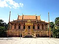 Khleang Pagoda in Ward 6, Sóc Trăng City
 Bửu Sơn Pagoda (Also known as Clay Pagoda) in Sóc Trăng City
 La Hán Pagoda, Ward 8, Sóc Trăng City
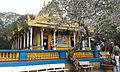 Main hall of Bat Pagoda (Mahatup), Ward 3, Sóc Trăng City
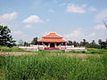 Đền thờ Bác Hồ - An Thạnh Đông, huyện Cù Lao Dung
 A corner of Sóc Trăng City
 Streets in Sóc Trăng City
 Maspero River, Sóc Trăng City
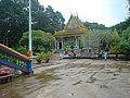 Mã Tộc Pagoda
 Theravada Buddhist Monastery, Sóc Trăng City
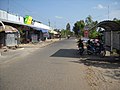 Cù Lao Dung, Sóc Trăng City
 Children play football in Long Phú, Sóc Trăng City
 Stupa at the temple Som Rong, Sóc Trăng City


