Hi.
I’m from São Paulo-SP, Brazil.
Some photos I’ve taken

 Larissa Costa, Miss Brasil 2009
 USB B to A plug adapter


Some maps I’ve originally created
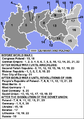 Germany and Poland borders during the 20th century (legends by User:Mosedschurte)
 Current German states that were completely or mostly situated inside the borders of the Kingdom of Prussia in the German Empire
 current US states that were completely or mostly located inside the borders of colonial French Louisiana at the time of Louisiana Purchase
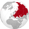 The maximum territorial extent of countries in the world under Soviet sphere of influence, after the Cuban Revolution of 1959 and before the official Sino-Soviet split of 1961


Some other images I’ve edited and uploaded
 Hyderabad state, 1909
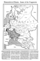 Ukraine, 1918
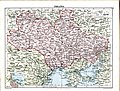 Ukraine, 1919
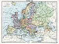 Europe in the aftermath of World War I, 1919
 Poland and the Baltic states, 1919
 Changes in the Grand Kremlin Palace façade between 1982 and 2008

.png)


