Geography
Main article: Geography of Africa
Africa is the largest continent in the southern hemisphere. It has an estimated area of 30,360,288 km² including the surrounding islands.
Africa is seporated from Europe by the Mediterranean Sea, although it is joined to Asia by the Isthmus of Suez (crossed by the Suez Canel), 130km wide. From the most northern point (Cape Blanc in Tunisia) to the southern point (Cape Agulhas in South Africa) is aproxomatly 8,000 km.
Geographical Facts
- The largest mountain in Africa is Kilimanjaro, Tanzania. (19,335.6 ft).
- The largest river in Africa is Nile, Egypt. (6,695 km).
- The largest desert in Africa Sahara Desert, crossing Algeria; Libya; Morocco; Western Sahara; Mauritania; Mali; Niger; Chad; Sudan; Eygpt
Languages

Main article: African languages
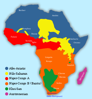
By most estimates Africa contains well over a thousand languages. There are four major language families native to Africa.
- The Afro-Asiatic languages are a language family of about 240 languages.
- The Nilo-Saharan language family consists of more than a hundred languages.
- The Niger-Congo language family covers much of Sub-Saharan Africa and is probably the largest language family in the world in terms of different languages.
- The Khoisan languages number about 50.
With a few notable exceptions in East Africa, nearly all African countries have adopted official languages that originated outside the continent and spread through colonialism or human migration. For example, in numerous countries English and French are used for communication in the public sphere such as government, commerce, education and the media.
Territories


| Name of territory, with flag | Area (km²) | Population (1 July 2002 est.) | Population density (per km²) | Capital |
|---|---|---|---|---|
| Eastern Africa[1]: | ||||
 Burundi Burundi | 27,830 | 6,373,002 | 229.0 | Bujumbura |
 Comoros Comoros | 2,170 | 614,382 | 283.1 | Moroni |
 Djibouti Djibouti | 23,000 | 472,810 | 20.6 | Djibouti |
 Eritrea Eritrea | 121,320 | 4,465,651 | 36.8 | Asmara |
 Ethiopia Ethiopia | 1,127,127 | 67,673,031 | 60.0 | Addis Ababa |
 Kenya Kenya | 582,650 | 31,138,735 | 53.4 | Nairobi |
 Madagascar Madagascar | 587,040 | 16,473,477 | 28.1 | Antananarivo |
 Malawi Malawi | 118,480 | 10,701,824 | 90.3 | Lilongwe |
 Mauritius Mauritius | 2,040 | 1,200,206 | 588.3 | Port Louis |
 Mayotte (France) Mayotte (France) | 374 | 170,879 | 456.9 | Mamoudzou |
 Mozambique Mozambique | 801,590 | 19,607,519 | 24.5 | Maputo |
 Réunion (France) Réunion (France) | 2,512 | 743,981 | 296.2 | Saint-Denis |
 Rwanda Rwanda | 26,338 | 7,398,074 | 280.9 | Kigali |
 Seychelles Seychelles | 455 | 80,098 | 176.0 | Victoria |
 Somalia Somalia | 637,657 | 7,753,310 | 12.2 | Mogadishu |
 Tanzania Tanzania | 945,087 | 37,187,939 | 39.3 | Dodoma |
 Uganda Uganda | 236,040 | 24,699,073 | 104.6 | Kampala |
 Zambia Zambia | 752,614 | 9,959,037 | 13.2 | Lusaka |
 Zimbabwe Zimbabwe | 390,580 | 11,376,676 | 29.1 | Harare |
| Middle Africa: | ||||
 Angola Angola | 1,246,700 | 10,593,171 | 8.5 | Luanda |
 Cameroon Cameroon | 475,440 | 16,184,748 | 34.0 | Yaoundé |
 Central African Republic Central African Republic | 622,984 | 3,642,739 | 5.8 | Bangui |
 Chad Chad | 1,284,000 | 8,997,237 | 7.0 | N'Djamena |
 Congo Congo | 342,000 | 2,958,448 | 8.7 | Brazzaville |
 Democratic Republic of the Congo Democratic Republic of the Congo | 2,345,410 | 55,225,478 | 23.5 | Kinshasa |
 Equatorial Guinea Equatorial Guinea | 28,051 | 498,144 | 17.8 | Malabo |
 Gabon Gabon | 267,667 | 1,233,353 | 4.6 | Libreville |
 São Tomé and Príncipe São Tomé and Príncipe | 1,001 | 170,372 | 170.2 | São Tomé |
| Northern Africa: | ||||
 Algeria Algeria | 2,381,740 | 32,277,942 | 13.6 | Algiers |
 Egypt[2] Egypt[2] | 1,001,450 | 70,712,345 | 70.6 | Cairo |
 Libya Libya | 1,759,540 | 5,368,585 | 3.1 | Tripoli |
 Morocco Morocco | 446,550 | 31,167,783 | 69.8 | Rabat |
 Sudan Sudan | 2,505,810 | 37,090,298 | 14.8 | Khartoum |
 Tunisia Tunisia | 163,610 | 9,815,644 | 60.0 | Tunis |
 Western Sahara (Morocco)[3] Western Sahara (Morocco)[3] | 266,000 | 256,177 | 1.0 | El Aaiún |
| Southern Europe dependencies in Northern Africa: | ||||
 Canary Islands (Spain)[4] Canary Islands (Spain)[4] | 7,492 | 1,694,477 | 226.2 | Las Palmas de Gran Canaria, Santa Cruz de Tenerife |
 Ceuta (Spain)[5] Ceuta (Spain)[5] | 20 | 71,505 | 3,575.2 | — |
 Madeira Islands (Portugal)[6] Madeira Islands (Portugal)[6] | 797 | 245,000 | 307.4 | Funchal |
 Melilla (Spain)[7] Melilla (Spain)[7] | 12 | 66,411 | 5,534.2 | — |
| Southern Africa: | ||||
 Botswana Botswana | 600,370 | 1,591,232 | 2.7 | Gaborone |
 Lesotho Lesotho | 30,355 | 2,207,954 | 72.7 | Maseru |
 Namibia Namibia | 825,418 | 1,820,916 | 2.2 | Windhoek |
 South Africa South Africa | 1,219,912 | 43,647,658 | 35.8 | Bloemfontein, Cape Town, Pretoria[8] |
 Swaziland Swaziland | 17,363 | 1,123,605 | 64.7 | Mbabane |
| Western Africa: | ||||
 Benin Benin | 112,620 | 6,787,625 | 60.3 | Porto-Novo |
 Burkina Faso Burkina Faso | 274,200 | 12,603,185 | 46.0 | Ouagadougou |
 Cape Verde Cape Verde | 4,033 | 408,760 | 101.4 | Praia |
 Côte d'Ivoire Côte d'Ivoire | 322,460 | 16,804,784 | 52.1 | Abidjan, Yamoussoukro[9] |
 Gambia Gambia | 11,300 | 1,455,842 | 128.8 | Banjul |
 Ghana Ghana | 239,460 | 20,244,154 | 84.5 | Accra |
 Guinea Guinea | 245,857 | 7,775,065 | 31.6 | Conakry |
 Guinea-Bissau Guinea-Bissau | 36,120 | 1,345,479 | 37.3 | Bissau |
 Liberia Liberia | 111,370 | 3,288,198 | 29.5 | Monrovia |
 Mali Mali | 1,240,000 | 11,340,480 | 9.1 | Bamako |
 Mauritania Mauritania | 1,030,700 | 2,828,858 | 2.7 | Nouakchott |
 Niger Niger | 1,267,000 | 10,639,744 | 8.4 | Niamey |
 Nigeria Nigeria | 923,768 | 129,934,911 | 140.7 | Abuja |
 Saint Helena (UK) Saint Helena (UK) | 410 | 7,317 | 17.8 | Jamestown |
 Senegal Senegal | 196,190 | 10,589,571 | 54.0 | Dakar |
 Sierra Leone Sierra Leone | 71,740 | 5,614,743 | 78.3 | Freetown |
 Togo Togo | 56,785 | 5,285,501 | 93.1 | Lomé |
| Total | 30,368,609 | 843,705,143 | 27.8 | |
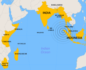
Dec, 2004 Tsunami

- Effect on Somalia
- Villages and coastal communities in Somalia, as far as 4,500 km (2,800 mi) from the epicentre of the earthquake, were swept away and destroyed by the huge waves. 176 people were confirmed dead, 136 were missing and more than 50,000 have been displaced.
- Kenya
- Waves struck Kenya causing some minor damage. One person reported drowned at Watamu, near Mombasa ([10]).
- South Africa
- Casualties: Two reported dead: One boy dead after swimming in the Quinera River at Gonubie, close to East London; an adult dead at Blue Horizon Bay near Port Elizabeth,[11] the furthest point from the epicentre of the earthquake where a tsunami-related death was reported. General observations: Ocean level variance two to three meters outside normal reported in KwaZulu-Natal and Eastern Cape, and a surge of 1.5m was observed as far as Struisbaai in the Western Cape, 8500km from the epicentre of the earthquake. Some steps were taken in South Africa to warn ports and disaster management centres, although full details are not public.[12] Damage: Large concrete blocks were uprooted in East London harbour, where boats also broke from their moorings [13]. Boats and cars were submerged at the Algoa Bay Yacht Club in Port Elizabeth harbour. [14] Durban harbour, Africa's busiest general cargo port and home to the largest and busiest container terminal in the Southern Hemisphere, [15] was closed for some time on 27 December because of unusually strong surges across the entrance channel [16].
- Tanzania
- Ten killed, an unknown number of people missing. Oil tanker temporarily ran aground in Dar es Salaam harbour, damaging an oil pipeline.
- Madagascar
- Flooding in low-lying coastal districts. No reported casualties. Waves reported variously as being between 1.6 and 10 metres in height swept through southeastern coastal areas near the towns of Manakara, Sambava and Vohemar — over 1,000 reported homeless. Problems were exacerbated by the approach of Cyclone Chambo. [17]
HIV Epidemic

HIV is most prominent in Southern Africa, where levels are between 15 and 50 percent of the adult population.
| Name of territorys (with flag) with 15-50% HIV adult population |
|---|
 South Africa South Africa |
 Namibia Namibia |
 Botswana Botswana |
 Zimbabwe Zimbabwe |
 Zambia Zambia |
 Lesotho Lesotho |
 Swaziland Swaziland |