Uttara Model Town or simply Uttara (Bengali: উত্তরা romanised: Uttora) is a neighbourhood of Dhaka, the capital of Bangladesh. The name derives from the Bengali word uttor (Bengali: উত্তর) meaning "north". It lies on the road to Gazipur, and adjoins Hazrat Shahjalal International Airport.
Uttara উত্তরা | |
|---|---|
| Uttara Model Town | |
.jpg) Skyline of Uttara, Dhaka | |
 | |
 Uttara Location of Uttara  Uttara Uttara (Bangladesh) | |
| Coordinates: 23°52′37″N 90°22′37″E / 23.877°N 90.377°E | |
| Country | |
| Division | Dhaka Division |
| District | Dhaka District |
| Metropolitan | DNCC |
| Establishment | 1966 |
| Founded by | RAJUK |
| Area | |
| • Total | 36.91 km2 (14.25 sq mi) |
| Elevation | 23 m (75 ft) |
| Population (2011) | |
| • Total | 179,907 |
| • Density | 4,874.20/km2 (12,624.1/sq mi) |
| Time zone | UTC+6 (BST) |
| Postal code | 1230 |
History
Planning
In 1966, Dhaka Improvement Trust planned to build a satellite town under North Satellite Town project in Dhaka District. In 1980, DIT changed the project name into Uttara Residential Model Town Project.[2]
First phase
RAJUK[note 1] completed the first phase of the project in 1992. In this phase Uttara had 6,000 plots. The total land for these plots was 950 acres.[4] Completed sectors in 1st phase are Sector 1, Sector 2, Sector 3, Sector 4, Sector 5, Sector 6, Sector 7, Sector 8, Sector 9, and Sector 10.
Second phase
New phase started after the completion of first phase. Second phase took 6 years to complete.[5] Completed sectors in 2nd phase are Sector 11, Sector 12, Sector 13, and Sector 14.
Third phase
During the course of the third phase circa 2,150 acres (8.7 km2) of land were acquired. About 10,000 residential plots and 225,512 apartments including amenities and urban facilities were provided.The estimated cost of third phase is Tk 23.16 billion. The deadline of the extension project was extended to June 2022.[4]Planned sectors in 3rd phase are Sector 15, Sector 16, Sector 17, and Sector 18.
Demographics
At the 2011 Bangladesh census, Uttara had a population of 179,907. According to 2011 figures, males constitute 56.33% of the population and females 43.67%, and about 80% of the Uttara's population are adults. Uttara has an average literacy rate of 90.49% (7+ years).[6]
Administration
Uttara is divided into administrative and geographical divisions named "Sectors". There are 18 sectors in Uttara.[7] Every sector is under a sector welfare association.[8] Uttara Association is the combination of these sector-wise associations.[9] The Suburb of Uttara is under two wards (Ward no. 1[10] and Ward no. 51[11]) of DNCC. Politically this area is under Dhaka-18 constituency.[12]
Ward councillor
| Ward | Area | Name | Ref. |
|---|---|---|---|
| 01 | Sector 1 to 10 | Afsar Uddin Khan | [13] |
| 51 | Sector 11 to 14 | Mohammad Sharifur Rahman | [14] |
Geography
Inner Uttara
- Sector 1
- Sector 2
- Sector 3
- Sector 4
- Sector 5
- Sector 6
- Sector 7
- Sector 8
- Sector 9
- Sector 10
- Sector 11
- Sector 12
- Sector 13
- Sector 14
- Sector 15
- Sector 16
- Sector 17
- Sector 18
Outer Uttara
- Uttarkhan/ Uttar Khan
- Dakshinkhan/ Dakshin Khan/ Daxinkhan
- Phulbaria[15] (Adjacent to Sector 10)
- Ranabhola[15] (Adjacent to Sector 10)
- Kamarpara[16] (Adjacent to Sector 10)
- Dhour
- Bamnartek
- Nolbhog[17]
- Noa Nagar
- Dolipara[15] (Adjacent to Sector 5)
- Katoitala (Adjacent to Sector 5)
- Pakuria[17]
- Diabari
- Khantek[17]
- Jatrabari[17]
- Ahalia[17]
- Ashkona
- Khalpar[15]
- Tarartek
- Abdullahpur[18] (Situated at the banks of Turag River, adjacent to sector 9)
Private Housing
Economy
Uttara is a planned city and one of the elite suburbs in Dhaka.[21] For that reason, and many other attractive features, Uttara is one of the most desirable residential areas in Dhaka.[22] According to a survey conducted by B-property in 2019, Uttara is the first choice of Dhaka residents for living. Mr Nuswardi is a Chief Executive of the property website named B-Property. He said to BBC Bangla that this planned satellite town is an important place in the capital of Bangladesh which has all necessary amenities and services the residents need. In the future, more and more people will start living in Purbachal, which is located adjacent to the town so it is a plus point. Uttara is preferable for many other reasons too.[23]
Uttara is a popular destination for shooting Bangladeshi dramas.[24][25]
Sector 7 Bridge is a popular destination for street food lovers. Home to many street food vendors, the suburbs also house many posh, luxurious restaurants and fine-dinings. Residents from other parts of Dhaka visit these restaurants frequently.[26]
Uttara has a large number of education institutions such as RAJUK Uttara Model College, Uttara High School and College, International University of Business Agriculture and Technology, Uttara University, Aeronautical Institute of Bangladesh. Uttara is also home to some of the city's most popular and prestigious schools of the English Medium curriculum such as Sunnydale, Sunbeams, Scholastica, International Hope School Bangladesh, Mastermind School .
Parks and recreation
Uttara Model Town has a total of 8 parks. Sectors 1, 2,4,5, 8, 9 and 10 have no parks. There are numerous lakes in Uttara except in sectors 1, 2, 6, 8, 10 and 12. [27] There is a children amusement park in sector 15 named Fantasy Island.[28]
Transportation
Roads
.jpg)
Many bus services give various transportation service in Uttara.[29] Many taxi services are available in this town such as Uber,[30] Pathao, Shohoz, InDrive, etc.
Rail
Residents of Uttara use the Dhaka Airport Railway Station to travel.[31] Situated opposite to Hazrat Shahjalal International Airport,[32] it is accessible via the Airport Road.

At present, the MRT Line 6 of Dhaka Metro connects Diabari of Uttara to Agargaon.There are three metro stations in Uttara under MRT Line 6, these include: Uttara North, Uttara Centre and Uttara South.[33]
Air

There is an airport situated in Kurmitola, Dhaka named Shahjalal International Airport. It can be accessed by the eight-lane Airport Road.[34] To the north of the airport lies Uttara area and Gazipur city, while Dhaka city lies to its south. There is a railway station immediately outside (facing) the airport named Airport Railway Station.[32]
Streets
Public institutions
Post Office
There is a sub-post office situated in sector 3.[42] Its postal code is 1231.
Fire Service
There is a fire service and civil defence station in Uttara.[43]
Regional Passport Office
Uttara has RPO (Regional Passport Office) situated in sector 12.[44]
Thanas
The town of Uttara has three thanas (police stations).
Hospitals
- Aichi Hospital[41]
- Al Ashraf General Hospital[41]
- Kuwait Bangladesh Friendship Government Hospital
- Radical Hospital[45]
- Shin Shin Japan Hospital[45]
- Uttara Adhunik Medical College & Hospital[46]
- Japan East West Medical College Hospital[47]
- Women and Children's Hospital, Uttara[48]
- Ahsania Mission Cancer & General Hospital
Education
Schools
- Aga Khan School, Dhaka
- Armed Police Battalion High School
- Azampur Government Primary School
- Bangladesh International Tutorial (BIT)
- Belmont International School
- Blooming Flower School
- Child Plan School
- Don Bosco School and College
- DPS STS School
- Euro International School
- Green Lawn School and College
- Heritage International College
- International Turkish Hope School, Dhaka
- Kids Campus School
- Life Preparatory School
- MaHaad International School
- Mastermind School
- Mileshium School
- Milestone College
- Moajjem Hossain Ideal School & College
- Nawab Habibullah Model School & College
- Oxford International School, Uttara campus
- Peace International School (PIS)
- Premier School Dhaka (PSD)
- Rangon Academy
- Rajuk Uttara Model College
- Rangon Art School
- Red Brick School
- Scholastica school
- Sky Touch School
- South Breeze School
- Sunbeams School
- Sunnydale
- The Headway School
- Time International Academy
- Uttara High School and College
- Uttara Model College
- Uttara Model School
- Uttara Town College
Colleges and universities
- Aeronautical Institute of Bangladesh
- Aeronautical College of Bangladesh
- Asian University
- Atish Dipankar University of Science and Technology
- BGMEA Institute of Fashion & Technology
- Heritage International College of Aviation Science and Management
- International University of Business Agriculture and Technology
- Shanto Mariam University of Creative Technology
- Tagore University of Creative Arts
- Uttara University
Medical colleges
- Japan East West Medical College Hospital[47]
- Medical College for Women and Hospital
- Shaheed Monsur Ali Medical College
- Uttara Adhunik Medical College & Hospital[46]
Gallery
 Chowrasta in Uttara
 Alaul Avenue
 Shah Makhdum Avenue
 Sector 15 lake
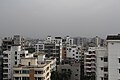 Skyline of Uttara
 Road in Uttara
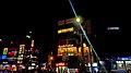 House building at night
 A lake in Uttara
 North Tower, Uttara
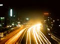 Night view of Uttara
 A commercial building in Uttara
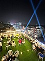 A rooftop restaurant in Uttara

.jpg)

.jpg)


.jpg)


See also

Notes
References
External links
 Media related to Uttara at Wikimedia Commons
- Farooque, Abu Hasan (2012). "Uttara Thana". In Islam, Sirajul; Jamal, Ahmed A. (eds.). Banglapedia: National Encyclopedia of Bangladesh (Second ed.). Asiatic Society of Bangladesh.