Archivo:Satellite image of Bolivia in June 2002.jpg

Tamaño de esta previsualización: 521 × 600 píxeles. Otras resoluciones: 208 × 240 píxeles · 417 × 480 píxeles · 667 × 768 píxeles · 889 × 1024 píxeles · 1778 × 2048 píxeles · 5279 × 6079 píxeles.
Ver la imagen en su resolución original (5279 × 6079 píxeles; tamaño de archivo: 4,02 MB; tipo MIME: image/jpeg)
Resumen
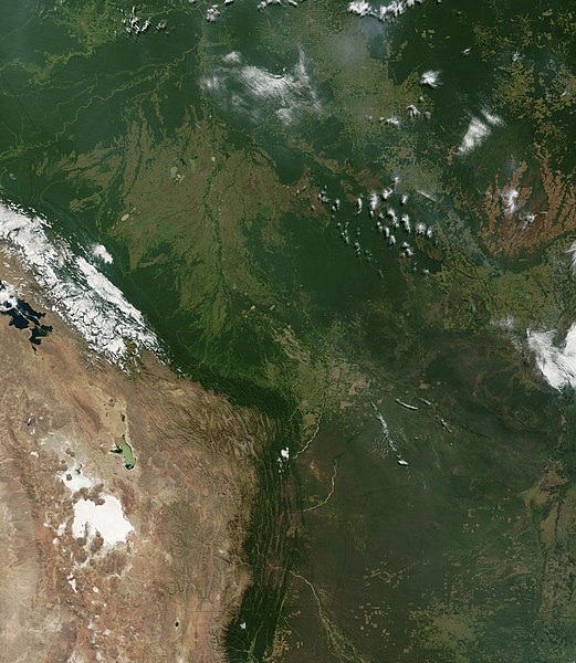
| Descripción | Satellite image of Bolivia in June 2002. Normally obscured by clouds, Bolivia is amazingly clear in this true-color MODIS image acquired June 20, 2002. Bounded by Brazil to the north and east, Paraguay and Argentina to the south, and Peru and Chile to the west, Bolivia is completely landlocked. A good portion of Bolivia is dominated by the Andes, but it also lays claim to lush forests and pasture lands in the Amazon Basin.Bolivia's agricultural crops include soybeans, coffee, coca, cotton, corn, sugarcane, rice, potatoes, and timber. A number of agricultural plots are visible in central Bolivia. Some large plots are arranged in a circular star shape, with water sources at the center and the agricultural plots radiating outwards. Adjacent to them (down and to the right) are more traditional shaped plots (more rectangular).One of Bolivia's main exports is tropical timber. Visible in this image are areas where the timber has been harvested. The deforestation patterns tend to follow major roads first, then smaller roads adjoining main roads. These patterns resemble the growth of ice crystals and are best viewed in the higher resolutions of this image. Deforestation is visible along the green edge of the Andes in central Bolivia. |
| Fecha | |
| Fuente | Slightly cropped from: http://visibleearth.nasa.gov/view_rec.php?id=3261 |
| Autor | Jacques Descloitres, MODIS Land Rapid Response Team, NASA/GSFC |
Licencia
| Este archivo es de dominio público porque fue creado por la NASA. Las políticas sobre copyright de la NASA estipulan que «el material de la NASA no está protegido con copyright a menos que se indique lo contrario». (Políticas sobre copyright de la NASA o Políticas sobre la utilización de imágenes del Jet Propulsion Laboratory). | ||
 | Advertencias:
|
Historial del archivo
Haz clic sobre una fecha y hora para ver elarchivo tal como apareció en ese momento.
| Fecha y hora | Miniatura | Dimensiones | Usuario | Comentario | |
|---|---|---|---|---|---|
| actual | 16:40 18 dic 2004 | | 5279 × 6079 (4,02 MB) | Hautala | {{PD-USGov-NASA}} Satellite image of Bolivia in June 2002. Slightly cropped image taken originally from http://visibleearth.nasa.gov/cgi-bin/viewrecord?16839 . Normally obscured by clouds, Bolivia is amazingly clear in this true-color MODIS image acquired |
Usos del archivo
Las siguientes páginas usan este archivo:
Uso global del archivo
Las wikis siguientes utilizan este archivo:
- Uso en af.wikipedia.org
- Uso en ast.wikipedia.org
- Uso en de.wikipedia.org
- Uso en dz.wikipedia.org
- Uso en en.wikipedia.org
- Uso en fr.wikipedia.org
- Uso en gcr.wikipedia.org
- Uso en hi.wikipedia.org
- Uso en hr.wikipedia.org
- Uso en ne.wikipedia.org
- Uso en qu.wikipedia.org
- Uso en sr.wikipedia.org
- Uso en te.wikipedia.org
- Uso en uk.wikipedia.org
Metadatos
🔥 Top keywords: Wikipedia:PortadaLiga de Campeones de la UEFAEspecial:BuscarLiga de Campeones de la UEFA 2023-24Cleopatra I de EgiptoReal Madrid Club de FútbolBayern de MúnichRevolución del 19 de abril de 1810Arsenal Football ClubAndriy LuninManchester City Football ClubPornhubJude BellinghamTabla periódica de los elementosYouTubeChatGPTCarlo AncelottiPep GuardiolaJérémy DokuAntonio RíosÁlex de MiñaurBorussia DortmundFútbol Club BarcelonaRafael NadalCleopatraFallout (serie)Antonio RüdigerCopa Mundial de Clubes de la FIFA 2025Erling HaalandGabriel García MárquezArroba (símbolo)Fallout (serie de televisión)BaloncestoRodri HernándezSegunda Guerra MundialLockheed Martin F-16 Fighting FalconCristiano RonaldoOusmane DembéléBrahim Díaz