Íomhá:Umayyad750ADloc.png

Size of this preview: 800 × 487 picteilín. Other resolutions: 320 × 195 picteilín | 640 × 390 picteilín | 1,024 × 624 picteilín | 1,481 × 902 picteilín.
Taispeáin leagan ardtaifigh den íomhá (1,481 × 902 picteilín, méid comhaid: 44 KB, cineál MIME: image/png)
Stair chomhaid
Cliceáil ar dáta/am chun an comhad a radharc mar a bhí sé ag an am sin.
| Dáta/Am | Mionsamhail | Toisí | Úsáideoir | Nóta tráchta | |
|---|---|---|---|---|---|
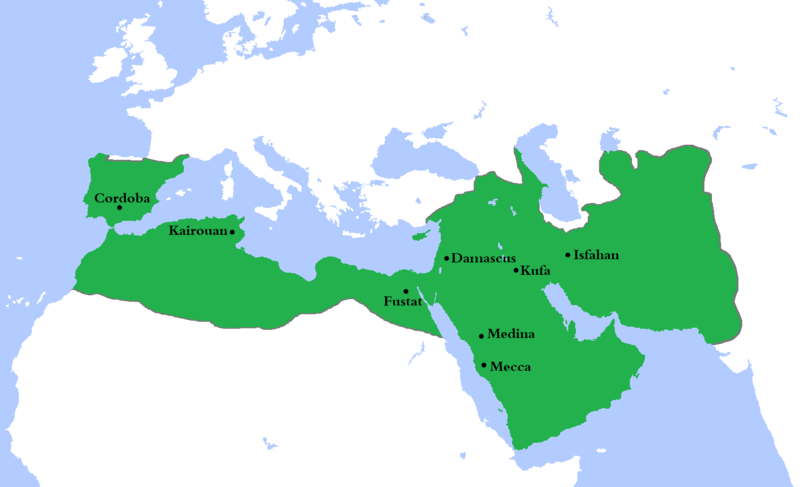
| faoi láthair | 22:23, 4 Lúnasa 2020 |  | 1,481 × 902 (44 KB) | Ozan33Ankara | Corrected borders based on: The expansion of the Muslim Caliphate until 750, from William R. Shepherd's Historical Atlas. |
| 15:24, 11 Aibreán 2013 |  | 1,481 × 902 (30 KB) | HistoryofIran | {{subst:Upload marker added by en.wp UW}} {{Information |Description = {{en|Made the map more presice, the Umayyads never controlled Tabaristan because of the Dabuyid dynasty, but the Abbasids did that later.}} |Source = http://en.wikipedia.org/wiki/Fi... | |
| 15:55, 10 Aibreán 2013 |  | 1,481 × 902 (37 KB) | Khateeb88 | Added the major cities of the Umayyad Caliphate: Damascus, Kufa, Isfahan, Mecca, Medina, Fustat, Kairouan, and Cordoba. | |
| 15:54, 10 Aibreán 2013 |  | 1,481 × 902 (37 KB) | Khateeb88 | Added the major cities of the Umayyad Caliphate: Damascus, Kufa, Isfahan, Mecca, Medina, Fustat, Kairouan, and Cordoba. | |
| 16:17, 22 Aibreán 2009 |  | 1,481 × 902 (50 KB) | Gabagool | some corrections.. | |
| 16:10, 20 Aibreán 2009 |  | 1,481 × 902 (50 KB) | Gabagool | {{Information |Description={{en|1=Locator map for the Umayyad Caliphate at its greatest extent, c. AD 750. (Partially based on ''Atlas of World History'' (2007) - World 500-750, map.)}} |Source=Own work by uploader |Author=Gabagool / Ja |
Úsáid comhaid
Tá nasc chuig an gcomhad seo ar na leathanaigh seo a leanas:
Global file usage
The following other wikis use this file:
- Úsáid ar af.wikipedia.org
- Úsáid ar als.wikipedia.org
- Úsáid ar an.wikipedia.org
- Úsáid ar ast.wikipedia.org
- Úsáid ar av.wikipedia.org
- Úsáid ar az.wikipedia.org
- Úsáid ar ba.wikipedia.org
- Úsáid ar be.wikipedia.org
- Úsáid ar bg.wikipedia.org
- Úsáid ar bn.wikipedia.org
- Úsáid ar br.wikipedia.org
- Úsáid ar bs.wikipedia.org
- Úsáid ar ca.wikipedia.org
- Úsáid ar ckb.wikipedia.org
- Úsáid ar cy.wikipedia.org
- Úsáid ar da.wikipedia.org
- Úsáid ar de.wikipedia.org
- Úsáid ar el.wikipedia.org
- Úsáid ar en.wikipedia.org
View more global usage of this file.
Meiteasonraí
🔥 Top keywords: PríomhleathanachCarles PuigdemontAn tAontas SóivéadachGene SimmonsVicipéid:Halla baileStáit Aontaithe MheiriceáSpeisialta:RecentChangesSpeisialta:SearchSouth Park: Bigger, Longer & UncutVicipéid:Séanadh ginearáltaAn Dara Cogadh DomhandaVicipéid:CabhairVicipéid:Lárionad comhphobailAn VicipéidRíocht Aontaithe na Breataine Móire agus Thuaisceart ÉireannVicipéid:Cúrsaí reathaGluaiseacht (úrscéal)Juan Antonio VillacañasJean SimmonsTeach na nIonadaithe, Stáit Aontaithe MheiriceáJohn HumePádraig Mac SuibhneAn GhaeilgeAn AramaisRobert FicoVicipéid:RéamhráÚsáideoir:MALA2009/Síscéal (Béarla)Catagóir:Síolta tíreolaíochta na hÉireannPápa Cléimeans VIIHippuris vulgarisCruidín crainnMarie Antoinette na hOstaireCúcabarraGradaim an AcadaimhSpeisialta:MyTalkPeter PellegriniSpeisialta:MyContributionsComhriachtainRéileán láibe

