

Eredeti fájl (SVG fájl, névlegesen 1 639 × 1 852 képpont, fájlméret: 389 KB)
Ez a fájl a Wikimedia Commonsból származik. Az alább látható leírás az ottani dokumentációjának másolata. A Commons projekt szabad licencű kép- és multimédiatár. Segíts te is az építésében! |
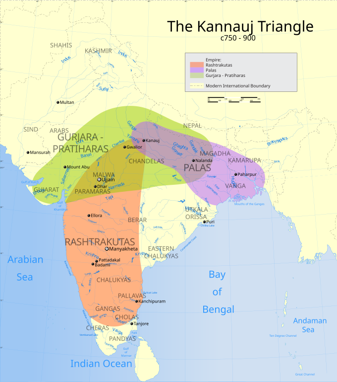
| Cím | The Kanauj Triangle 750-900BC |
| LeírásIndian Kanauj triangle map.svg | Map showing the extent of the Rashtrakuta, Rajput and Pala empires. |
| Map legend |  |
| Dátum | |
| Forrás | A feltöltő saját munkája |
| Alkotó | |
| Engedély (Fájl újrafelhasználása) | Én, e mű szerzője a művemet az alábbi licenc alatt teszem közzé: Ez a fájl a Creative Commons Nevezd meg! – Így add tovább! 3.0 Unported licenc alapján használható fel.
|
| Geotemporal data | |
| Ábrázolt időpont | 20. évszázad második felében és 21. évszázad |
| Spatial reference system | conic |
| Bounding box | |
| Georeferencing | Georeference the map in Wikimaps Warper If inappropriate please set warp_status = skip to hide. |
| Archival data | |
| Megjegyzés | Part of WikiProject India Maps |


The depicted extent of the former territory of the British Indian Empire, succeeded by Republic of India, may not be accepted by few countries as legal due to ongoing border disputes:
For a detailed map of all disputed regions in South Asia, see Image:India disputed areas map.svg
The borders of the state of Meghalaya, Assam and Arunachal Pradesh are shown as interpreted from the North-Eastern Areas (Reorganisation) Act, 1971, but has yet to be verified.
The limit of the territorial waters of India extends to twelve nautical miles measured from the appropriate baseline. See this for more information.
Kattints egy időpontra, hogy a fájl akkori állapotát láthasd.
| Dátum/idő | Bélyegkép | Felbontás | Feltöltő | Megjegyzés | |
|---|---|---|---|---|---|
| aktuális | 2007. március 27., 08:40 | | 1 639 × 1 852 (389 KB) | Planemad | |
| 2007. március 26., 22:46 |  | 1 639 × 1 852 (389 KB) | Planemad | {{WikiProject_India_Maps |Title=The Kanauj Triangle |Description=Map showing the |Source= |Date=March 2006 |Author=w:user:Planemad }} |
Az alábbi lap használja ezt a fájlt:
A következő wikik használják ezt a fájlt:
A fájl globális használatának megtekintése
Ez a kép járulékos adatokat tartalmaz, amelyek feltehetően a kép létrehozásához használt digitális fényképezőgép vagy lapolvasó beállításairól adnak tájékoztatást. Ha a képet az eredetihez képest módosították, ezen adatok eltérhetnek a kép tényleges jellemzőitől.
| Szélesség | 1638.55 |
|---|---|
| Magasság | 1852.41 |
