

Oearsprunkelik bestandj (SVG-bestandj, nominaal 812 × 509 pixels, bestandsgruutde: 612 kB)
Dit besjtandj kump van Wikimedia Commons en kin ouch in anger projekte gebroek waere.De pagina mit de besjtandjsbesjrieving wurt hiejónger weergegaeve.
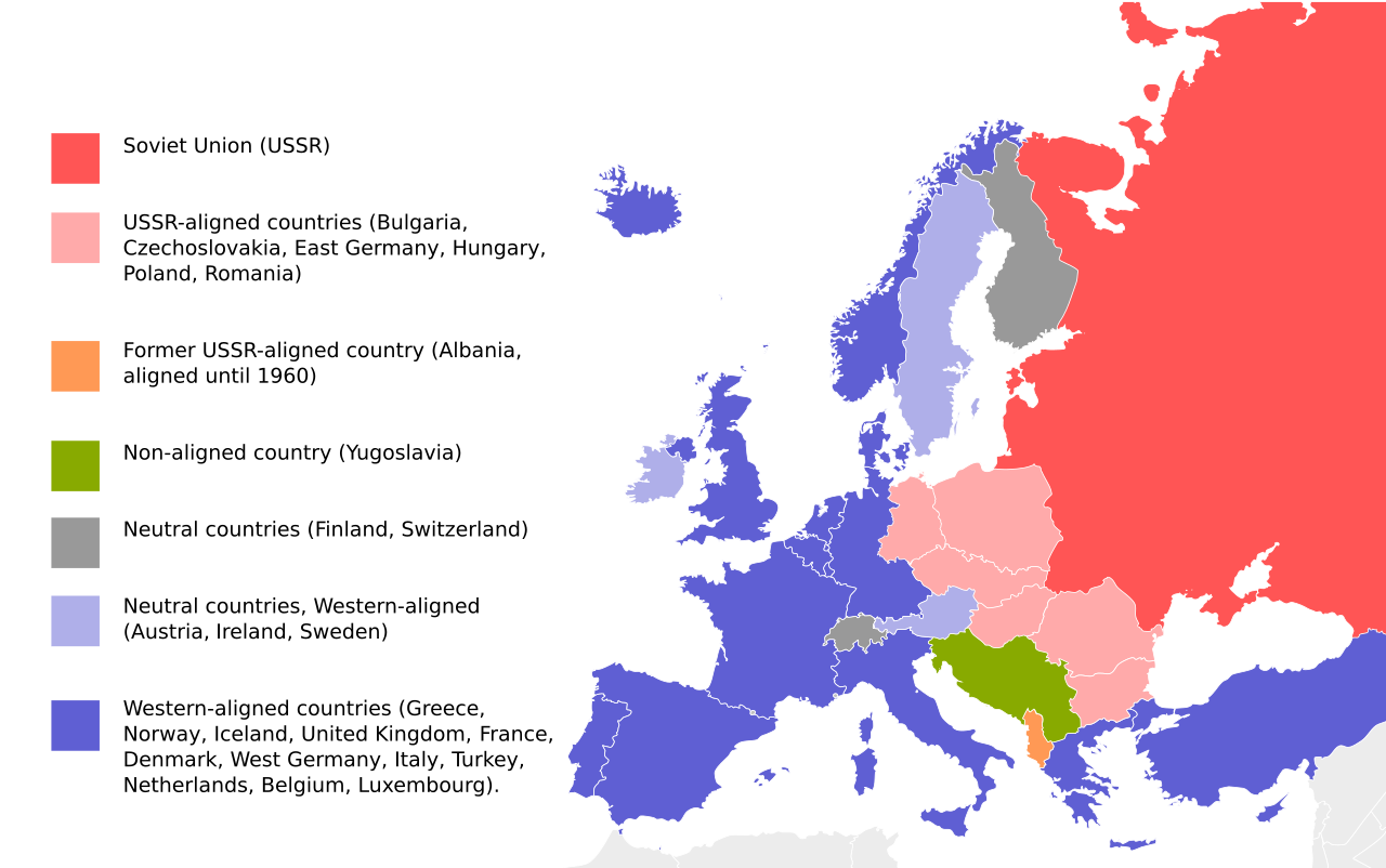
| BesjrievingEurope-blocs-49-89x4.svg | English: Cold War map of Eastern and Western Blocs in Europe. Map based on File:EU27-further_enlargement_map.svg |
| Datum | |
| Brón | File:EU27-further_enlargement_map.svg |
| Sjriever | UserGoldsztajn |
| Anger versies | [bewirk]
|
| Public domainPublic domainfalsefalse |
| Iech, de autäörsrechhöbbende vaan dit wirk, geef dit wirk vrij in 't publiek domein. Dit is wereldwijd vaan toupassing. In sommig len is dit wettelik neet meugelek; in die gevalle gelt: Ich staon ederein toe dit wirk veur ènnig doel te broeke, zónger ènnig veurwaerj, behauve zölk veurwaerj dóre wet waere veurgesjreve. |
| Annotations InfoField | This image is annotated: View the annotations at Commons |
France is lilac in the legend and indigo in the map (needs to be fixed)
Klik op 'ne datum/tied óm 't besjtand te zeen wie 't oetzaog op det tiedsjtip.
| Datum/Tied | Miniatuurplaetje | Aafmaetinge | Gebroeker | Kómmentaar | |
|---|---|---|---|---|---|
| hujig | 2 okt 2023 21:33 | | 812 × 509 (612 kB) | Gooduserdude | Reverted to version as of 22:37, 1 June 2019 (UTC) |
| 19 sep 2023 00:58 |  | 812 × 509 (238 kB) | Quetz72 | File uploaded using svgtranslate tool (https://svgtranslate.toolforge.org/). Added translation for ca. | |
| 1 apr 2022 06:10 |  | 812 × 509 (237 kB) | Yle-radio 1 | * | |
| 2 jun 2019 00:37 |  | 812 × 509 (612 kB) | Pedro8790 | Reverted to version as of 18:19, 22 September 2018 (UTC) | |
| 30 mei 2019 19:46 |  | 800 × 501 (198 kB) | Koldo Biguri | Translated into Basque | |
| 22 sep 2018 20:19 |  | 812 × 509 (612 kB) | Nablicus | correction France | |
| 13 jul 2018 14:06 |  | 812 × 509 (694 kB) | Nablicus | France was not neutral | |
| 2 apr 2009 09:29 |  | 812 × 509 (694 kB) | Goldsztajn | reedit | |
| 2 apr 2009 09:09 |  | 812 × 509 (694 kB) | Goldsztajn | reedit | |
| 2 apr 2009 08:58 |  | 812 × 509 (671 kB) | Goldsztajn | reedit |
Dit plaetje weurt op de volgende pazjena's gebroek:
De volgende anger wiki's gebroeke dit bestandj:
Bekiek wikiwied gebroek van dit bestandj.
Dit besjtand bevat extra gegaeves, waorsjienlik door de digitale camera of scanner biegevoog. Es 't oersjprunkelik besjtand aangepas is, kin 't zeen dat sómmige details neet mie bie 't gewiezigde plaetje hure.
| Omsjrieving aafbeilding | A blank Map of Europe. Every country has an id which is its ISO-3116-1-ALPHA2 code in lower case.Members of the EU have a class="eu", countries in europe (which I found turkey to be but russia not) have a class="europe".Image based on a map (http://commons.wikimedia.org/wiki/Image:Europe_countries.svg) by Júlio "Tintazul" Reis.made by Marian "maix" Sigler. Released under CreativeCommons Attribution ShareAlike (http://creativecommons.org/licenses/by-sa/2.5/). |
|---|---|
| Breidte | 811.57208 |
| Hoogte | 508.59 |


