Jump to content

Pepin County, Wisconsin

92°00′W / 44.60°N 92.00°W / 44.60; -92.00
From Simple English Wikipedia, the free encyclopedia
Pepin County
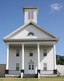
Historic Pepin County Courthouse Museum in Durand, Wisconsin
Map of Wisconsin highlighting Pepin County
Location within the U.S. state of Wisconsin
Map of the United States highlighting Wisconsin
Wisconsin's location within the U.S.
Coordinates: 44°36′N 92°00′W / 44.6°N 92°W / 44.6; -92
Country United States
State Wisconsin
FoundedFebruary 25, 1858
Named forLake Pepin
SeatDurand
Largest cityDurand
Area
 • Total249 sq mi (640 km2)
 • Land232 sq mi (600 km2)
 • Water17 sq mi (40 km2)  6.7%
Population
 • Total7,318
 • Density31.5/sq mi (12.2/km2)
Time zoneUTC−6 (Central)
 • Summer (DST)UTC−5 (CDT)
Congressional district3rd
Websitewww.co.pepin.wi.us

Pepin County is a county in the U.S. state of Wisconsin. As of 2020, 7,318 people lived there.[1] Its county seat is Durand.[2]

Laura Ingalls Wilder was born in Pepin County.

Historychange source

Historical population
CensusPop.
18602,392
18704,65994.8%
18806,22633.6%
18906,93211.3%
19007,90514.0%
19107,577−4.1%
19207,481−1.3%
19307,450−0.4%
19407,8976.0%
19507,462−5.5%
19607,332−1.7%
19707,319−0.2%
19807,4772.2%
19907,107−4.9%
20007,2131.5%
20107,4693.5%
20207,318−2.0%
U.S. Decennial Census[3]
1790–1960[4] 1900–1990[5]
1990–2000[6] 2010–2020[1]

Pepin County was formed in 1858 from parts of Dunn County. It was named after the French conquistadors Pierre and Jean Pepin du Chardonnets.

Geographychange source

The county has a total area of 249 square miles (644.9 km2). Of this, 232 square miles (600.9 km2) is land and 16 square miles (41.4 km2) (6.59%) is water. Pepin County is the smallest county in Wisconsin.

Cities, villages, and townschange source

  • Albany
  • Durand (town)
  • Durand
  • Frankfort
  • Lima
  • Pepin (town)
  • Pepin
  • Stockholm (town)
  • Stockholm
  • Waterville
  • Waubeek

Unincorporated communitieschange source

  • Arkansaw
  • Barry Corner
  • Devils Corner
  • Ella
  • Hawkins Corner
  • Lakeport
  • Lima
  • Lund
  • Porcupine
  • Tarrant

Referenceschange source

Other websiteschange source

44°36′N 92°00′W / 44.60°N 92.00°W / 44.60; -92.00
🔥 Top keywords: Main PageSpecial:SearchModule:Track gauge/dataSOLID (object-oriented design)Wikipedia:AboutHelp:ContentsHelp:IntroductionSpecial:RecentChangesPornhubBlackAdolf Hitler UunonaFile:ASCII-Table-wide.svgList of constituencies of the Lok SabhaList of U.S. states and territories by time zoneSchrödinger's catList of U.S. states by date of admission to the UnionFile:Sexual intercourse with internal ejaculation.webmHeera MandiList of people who have walked on the MoonDavid24-hour clockModule:Emoji/dataLawrence WongCristiano RonaldoPeriodic tableList of countries by areaUnited StatesCategory:2000s American music groupsList of U.S. statesBismillahir Rahmanir RaheemList of fruitsQueen (band)Special:MyTalkXXXTentacionWikipedia:Contact usHelp:Authority controlWikipedia:Simple talkList of countries by continentsWikipedia:Simple start