

Tập tin gốc (1.920×1.920 điểm ảnh, kích thước tập tin: 5,23 MB, kiểu MIME: image/jpeg)
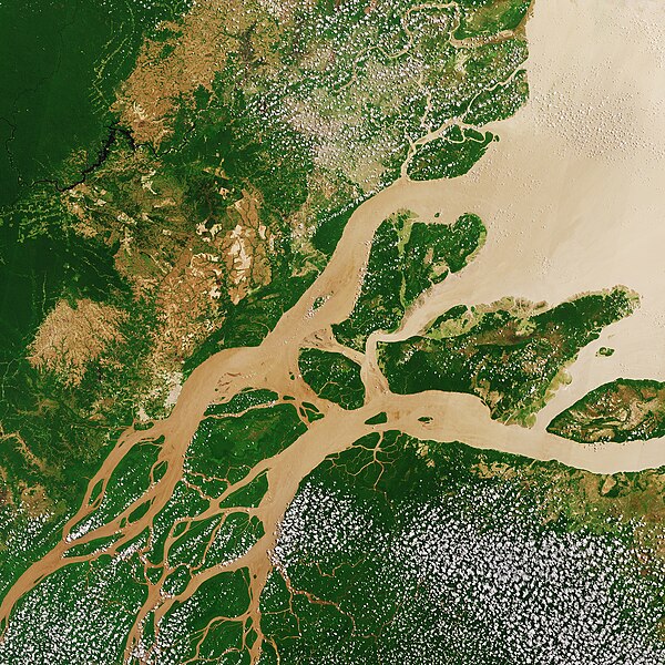
| Miêu tảAmazon River ESA387332.jpg | English: The Copernicus Sentinel-2A satellite takes us over northern Brazil on 22 August 2017, where the Amazon River meets the Atlantic Ocean (Amazon Delta). Click on the "media-viewer button" (and +) to view this image at its full 10 m resolution directly in your browser.The sediment-laden water appears brown as it flows from the lower left to the open ocean in the upper right. ‘Popcorn’ clouds (Cumulus humilis clouds) are visible in parts of the image – a common occurrence during the Amazon’s dry season, formed by condensed water vapour released by plants and trees during the sunny day.The land varies in colour from the deep green of dense vegetation to light brown. Taking a closer look to the upper-left section of the image, we can see large brown areas where the vegetation has already been cleared away. Geometric shapes indicate agricultural fields, and linear roads cut through the remaining dense vegetation.Rainforests worldwide are being destroyed at an alarming rate. This is of great concern because they play an important role in global climate, and are home to a wide variety of plants, animals and insects. More than a third of all species in the world live in the Amazon Rainforest.Unlike other forests, rainforests have difficulty regrowing after they are destroyed and, owing to their composition, their soils are not suitable for long-term agricultural use.With their unique view from space, Earth observation satellites have been instrumental in highlighting the vulnerability of the rainforests by documenting the scale of deforestation. This image is featured on theEarth from Space video programme. |
| Ngày | Taken on 22 tháng 8 năm 2017 |
| Nguồn gốc | http://www.esa.int/spaceinimages/Images/2017/12/Amazon_River |
| Tác giả | European Space Agency |
| Giấy phép (Dùng lại tập tin) | contains modified Copernicus Sentinel data (2017), processed by ESA,CC BY-SA 3.0 IGO |
| Phiên bản khác |
|
| Title InfoField | Amazon River |
| Set InfoField | Earth observation image of the week |
| System InfoField | Copernicus |
| Mission InfoField | Sentinel-2 |
| Location InfoField | Amazon Rainforest |
| Activity InfoField | Observing the Earth |
| Keywords InfoField | Rainforest |
| Có một hình được trích xuất từ hình này: Imagem de Satélite Ilha Caviana.jpg. |  |
This media was created by the European Space Agency (ESA). Where expressly so stated, images or videos are covered by the Creative Commons Attribution-ShareAlike 3.0 IGO (CC BY-SA 3.0 IGO) licence, ESA being an Intergovernmental Organisation (IGO), as defined by the CC BY-SA 3.0 IGO licence. The user is allowed under the terms and conditions of the CC BY-SA 3.0 IGO license to Reproduce, Distribute and Publicly Perform the ESA images and videos released under CC BY-SA 3.0 IGO licence and the Adaptations thereof, without further explicit permission being necessary, for as long as the user complies with the conditions and restrictions set forth in the CC BY-SA 3.0 IGO licence, these including that:
See the ESA Creative Commons copyright notice for complete information, and this article for additional details. |  | |
Tập tin này được phát hành theo giấy phép Creative Commons Ghi công–Chia sẻ tương tự 3.0 Tổ chức liên chính phủ (IGO). Ghi công: ESA, CC BY-SA IGO 3.0
| ||
 | This image contains data from a satellite in the Copernicus Programme, such as Sentinel-1, Sentinel-2 or Sentinel-3. Attribution is required when using this image. Ghi công: Contains modified Copernicus Sentinel data 2017Attribution The use of Copernicus Sentinel Data is regulated under EU law (Commission Delegated Regulation (EU) No 1159/2013 and Regulation (EU) No 377/2014). Relevant excerpts:
Free access shall be given to GMES dedicated data [...] made available through GMES dissemination platforms [...].
Access to GMES dedicated data [...] shall be given for the purpose of the following use in so far as it is lawful:
GMES dedicated data [...] may be used worldwide without limitations in time.
GMES dedicated data and GMES service information are provided to users without any express or implied warranty, including as regards quality and suitability for any purpose. |
Attribution
Nhấn vào ngày/giờ để xem nội dung tập tin tại thời điểm đó.
| Ngày/giờ | Hình xem trước | Kích cỡ | Thành viên | Miêu tả | |
|---|---|---|---|---|---|
| hiện tại | 16:57, ngày 1 tháng 12 năm 2017 | | 1.920×1.920 (5,23 MB) | Fæ | European Space Agency, Id 387332, http://www.esa.int/spaceinimages/Images/2017/12/Amazon_River, User:Fæ/Project_list/ESA |
Những wiki sau đang sử dụng tập tin này:
Tập tin này chứa thông tin bổ sung, có thể được thêm từ máy ảnh kỹ thuật số hoặc máy quét được sử dụng để tạo hoặc số hóa tệp.
Nếu tập tin đã được sửa đổi so với trạng thái ban đầu, một số chi tiết có thể không phản ánh đầy đủ tập tin đã sửa đổi.
| Chiều ngang | 24.569 điểm ảnh |
|---|---|
| Chiều cao | 24.570 điểm ảnh |
| Bit trên mẫu |
|
| Kiểu nén | Không nén |
| Thành phần điểm ảnh | RGB |
| Hướng | Thường |
| Số mẫu trên điểm ảnh | 3 |
| Phân giải theo bề ngang | 72 điểm/inch |
| Phân giải theo chiều cao | 72 điểm/inch |
| Cách xếp dữ liệu | định dạng thấp |
| Phần mềm sử dụng | Adobe Photoshop CC (Macintosh) |
| Ngày giờ sửa tập tin | 10:45, ngày 30 tháng 11 năm 2017 |
| Không gian màu | Chưa hiệu chỉnh |
| Ngày giờ số hóa | 10:28, ngày 20 tháng 9 năm 2017 |
| Ngày sửa siêu dữ liệu lần cuối | 11:45, ngày 30 tháng 11 năm 2017 |
| ID duy nhất của tài liệu gốc | xmp.did:9fcf1a83-ae84-5948-825a-1e661eeacf92 |
