
Tharsis_Tholus_block.JPG (284×463 điểm ảnh, kích thước tập tin: 16 kB, kiểu MIME: image/jpeg)
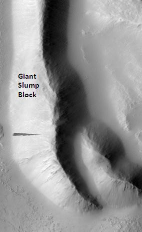
| Miêu tảTharsis Tholus block.JPG | English: Tharsis Tholus block, as seen by hirise. Location is 13.9 degrees north latitude and 267.8 degrees east longitude. Image was taken by the Mars Reconnaissance Orbiter's HiRISE. The HiRISE camera was built by Ball Aerospace and Technology orporation and is operated by the University of Arizona. Image courtesy NASA/JPL/University of Arizona. |
| Ngày | |
| Nguồn gốc | http://hirise.lpl.arizona.edu/PSP_007127_1940 |
| Tác giả | Jim Secosky modified NASA image. |
| Public domainPublic domainfalsefalse |
| This file is in the public domain in the United States because it was solely created by NASA. NASA copyright policy states that "NASA material is not protected by copyright unless noted". (See Template:PD-USGov, NASA copyright policy page or JPL Image Use Policy.) | ||
 | Warnings:
|
Chuyển từ en.wikipedia sang Commons by FrancescoA.
Nhấn vào ngày/giờ để xem nội dung tập tin tại thời điểm đó.
| Ngày/giờ | Hình xem trước | Kích cỡ | Thành viên | Miêu tả | |
|---|---|---|---|---|---|
| hiện tại | 06:00, ngày 19 tháng 4 năm 2009 | | 284×463 (16 kB) | FrancescoA | {{Information |Description={{en|Tharsis Tholus block, as seen by hirise. Location is 13.9 degrees north latitude and 267.8 degrees east longitude. Image was taken by the Mars Reconnaissance Orbiter's HiRISE. The HiRISE camera was built by Ball Aerospace |
Những wiki sau đang sử dụng tập tin này:
Tập tin này chứa thông tin bổ sung, có thể được thêm từ máy ảnh kỹ thuật số hoặc máy quét được sử dụng để tạo hoặc số hóa tệp.
Nếu tập tin đã được sửa đổi so với trạng thái ban đầu, một số chi tiết có thể không phản ánh đầy đủ tập tin đã sửa đổi.
| _error | 0 |
|---|