Ficheiro:NAS Cubi Point and NS Subic Bay.jpg

Dimensões desta antevisão: 800 × 547 píxeis. Outras resoluções: 320 × 219 píxeis | 640 × 437 píxeis | 1 024 × 700 píxeis | 1 280 × 875 píxeis | 2 780 × 1 900 píxeis.
Imagem numa resolução maior (2 780 × 1 900 píxeis, tamanho: 3,45 MB, tipo MIME: image/jpeg)
| | Esta imagem provém do Wikimedia Commons, um acervo de conteúdo livre da Wikimedia Foundation que pode ser utilizado por outros projetos.
|
Descrição do ficheiro
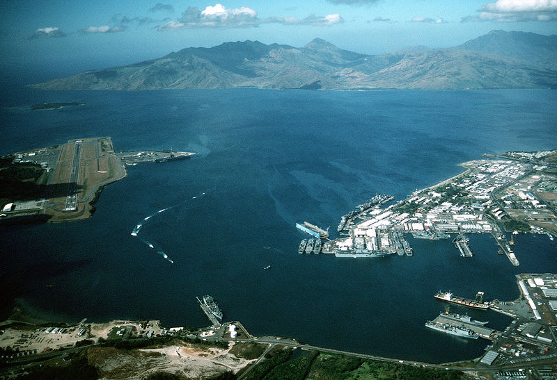
| Descrição | English: Aerial view of the U.S. Navy Naval Station Subic Bay, Philippines, circa in 1990, with Naval Air Station Cubi Point visible on the left. This photo was most probably taken in January of 1991, during the build-up to Operations DESERT SHIELD & DESERT STORM, but before the 12 June 1991 eruption of Mt. Pinatubo. In addition to the USS Ranger, moored at Leyte Pier, a Tarawa-class LHA is visible in the image, tied up in the maintenance area of the Subic Bay Naval Shipyard. The only Tarawa-class ship in the WestPac at the time was the Tarawa. The other west coast LHAs were both in port undergoing overhaul/maintenance in California (Belleau Wood (LHA 3) in San Diego and Peleliu (LHA 5) in Long Beach. Also visible at Alava Pier, above the Tarawa, is an Iwo Jima-class LPH, and at least seven other amphibious ships (LPD, LSD, LST). This is consistent with two full Amphibious Readiness Groups (ARGs) deployed for Operation DESERT SHIELD/DESERT STORM.Note: The photo is dated, incorrectly, as "1 January 1990". The aircraft carrier USS Ranger (CV 61) is docked at NAS Cubi Point. Ranger was deployed to the Western Pacific from 24 February to 24 August 1989 and to the Western Pacific and the Indian Ocean during the 1991 Gulf War from 8 December 1990 to 8 June 1991. | |||
| Data | cerca de 1990 | |||
| Origem |
| |||
| Autor | PH1(Nac) David R. Sanner, U.S. Navy |
| Localização da câmara | | Esta e outras imagens nas suas localizações em: OpenStreetMap |
|---|
Licenciamento
Esta imagem é uma obra de um marinheiro ou funcionário da Marinha dos E.U.A, tirada ou feita durante o curso de suas funções oficiais. Como uma obra do governo federal dos E.U.A, a imagem é de domínio público. |  | |
| Este ficheiro foi considerado livre de restrições conhecidas devidas a direitos de autor, incluindo todos os direitos conexos. | ||
Histórico do ficheiro
Clique uma data e hora para ver o ficheiro tal como ele se encontrava nessa altura.
| Data e hora | Miniatura | Dimensões | Utilizador | Comentário | |
|---|---|---|---|---|---|
| atual | 01h27min de 25 de abril de 2007 | | 2 780 × 1 900 (3,45 MB) | Dual Freq | {{Information |Description= |Source=[http://www.dodmedia.osd.mil/Assets/Still/1991/Navy/DN-ST-91-11630.JPEG ID:DN-ST-91-11630] |Author=Camera Operator: PH1(NAC) DAVID R. SANNER </br>Service Depicted: Navy An aerial view of the station and, to the left, N |
Utilização local do ficheiro
A seguinte página usa este ficheiro:
Utilização global do ficheiro
As seguintes wikis usam este ficheiro:
- arz.wikipedia.org
- ca.wikipedia.org
- ceb.wikipedia.org
- en.wikipedia.org
- fr.wikipedia.org
- fr.wikivoyage.org
- it.wikipedia.org
- ja.wikipedia.org
- nl.wikipedia.org
- pl.wikipedia.org
- sv.wikipedia.org
- uk.wikipedia.org
- vi.wikipedia.org
- www.wikidata.org
- zh.wikipedia.org
Metadados
🔥 Top keywords: Wikipédia:Página principalEspecial:PesquisarSilvio LuizAntero GrecoWashington RodriguesChatGPTCleópatraMárcia (cantora brasileira)Paulo SoaresYasukeYouTubeNova CaledóniaCandombléCássio RamosEnchentes no Rio Grande do Sul em 2024Verinha DarcyRio Grande do SulPablo MarçalSony ChannelAMBEVCanal BrasilEduardo LeiteFicheiro:Logotipo da GloboNews.pngBrasilDanubio Fútbol ClubSalomãoEslováquiaBaby ReindeerJuraj Cintula16 de maioPaulo PimentaWhatsAppHigh Frequency Active Auroral Research ProgramRobert FicoCopa Libertadores da América de 2024Club BolívarAlma GêmeaCopa Libertadores da AméricaCristiano Ronaldo