File:Kashmir-sat-nasa.jpg
Size of this preview: 600 × 600 pixels. Other resolutions: 240 × 240 pixels | 480 × 480 pixels | 640 × 640 pixels.
Original file (640 × 640 pixels, file size: 428 KB, MIME type: image/jpeg)
Summary
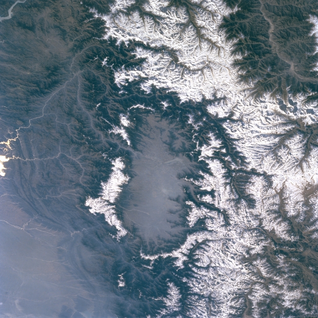
| Description | Kashmir Valley bordered by Karakorm Range in the north, Zanskar Range in the east and Pir Panjal Range in the west and south. |
| Date | before 2 April 2009 |
| Source | http://eol.jsc.nasa.gov/sseop/EFS/images.pl?photo=STS066-127-79 |
| Author | NASA |
Licensing
| This file is in the public domain in the United States because it was solely created by NASA. NASA copyright policy states that "NASA material is not protected by copyright unless noted". (See Template:PD-USGov, NASA copyright policy page or JPL Image Use Policy.) | ||
 | Warnings:
|
Original upload log
The original description page was here. All following user names refer to en.wikipedia.
- 2009-04-01 06:02 Doorvery far 640×640× (438485 bytes) Public domain nasa image: http://eol.jsc.nasa.gov/sseop/EFS/images.pl?photo=STS066-127-79
File history
Click on a date/time to view the file as it appeared at that time.
| Date/Time | Thumbnail | Dimensions | User | Comment | |
|---|---|---|---|---|---|
| current | 15:45, 17 May 2011 | | 640 × 640 (428 KB) | Woudloper | {{Information |Description={{en|Public domain NASA image: http://eol.jsc.nasa.gov/sseop/EFS/images.pl?photo=STS066-127-79}} |Source=Transferred from [http://en.wikipedia.org en.wikipedia] |Date={{Date|2009|04|01}} (original upload date) |Author=Original u |
File usage
The following page uses this file:
Global file usage
The following other wikis use this file:
- Usage on ar.wikipedia.org
- Usage on be.wikipedia.org
- Usage on bh.wikipedia.org
- Usage on bn.wikipedia.org
- Usage on de.wikipedia.org
- Usage on de.wikivoyage.org
- Usage on dty.wikipedia.org
- Usage on en.wikipedia.org
- Usage on en.wikivoyage.org
- Usage on es.wikipedia.org
- Usage on fa.wikipedia.org
- Usage on frr.wikipedia.org
- Usage on fr.wikipedia.org
- Usage on fr.wikinews.org
- Usage on fr.wikivoyage.org
- Usage on gu.wikipedia.org
- Usage on he.wikipedia.org
- Usage on hi.wikipedia.org
- Usage on id.wikipedia.org
- Usage on ja.wikipedia.org
- Usage on kn.wikipedia.org
- Usage on ko.wikipedia.org
- Usage on ks.wikipedia.org
- Usage on ml.wikipedia.org
- Usage on mr.wikipedia.org
- Usage on ms.wikipedia.org
- Usage on ne.wikipedia.org
- Usage on nl.wikipedia.org
- Usage on nn.wikipedia.org
- Usage on os.wikipedia.org
- Usage on pa.wikipedia.org
- Usage on pl.wikipedia.org
- Usage on pnb.wikipedia.org
- Usage on ru.wikipedia.org
- Usage on ru.wikinews.org
- Usage on sa.wikipedia.org
- Usage on sl.wikipedia.org
View more global usage of this file.
Metadata
🔥 Top keywords: Main PageSpecial:SearchModule:Track gauge/dataSOLID (object-oriented design)Wikipedia:AboutHelp:ContentsHelp:IntroductionSpecial:RecentChangesPornhubBlackAdolf Hitler UunonaFile:ASCII-Table-wide.svgList of constituencies of the Lok SabhaList of U.S. states and territories by time zoneSchrödinger's catList of U.S. states by date of admission to the UnionFile:Sexual intercourse with internal ejaculation.webmHeera MandiList of people who have walked on the MoonDavid24-hour clockModule:Emoji/dataLawrence WongCristiano RonaldoPeriodic tableList of countries by areaUnited StatesCategory:2000s American music groupsList of U.S. statesBismillahir Rahmanir RaheemList of fruitsQueen (band)Special:MyTalkXXXTentacionWikipedia:Contact usHelp:Authority controlWikipedia:Simple talkList of countries by continentsWikipedia:Simple start