Independence, Kansas
Independence is a city in and the county seat of Montgomery County, Kansas, United States.[4] In 2020, the 8,548 people lived there.[3] It was named after the Declaration of Independence.[5]
Independence, Kansas | |
|---|---|
City and County seat | |
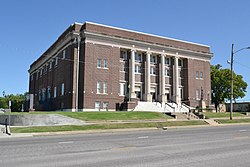
 Memorial Hall (2017) | |
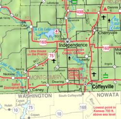
 Location within Montgomery County and Kansas | |
 | |
| Coordinates: 37°13′32″N 95°43′10″W / 37.22556°N 95.71944°W[1] | |
| Country | United States |
| State | Kansas |
| County | Montgomery |
| Founded | 1869 (Colfax) |
| Incorporated | 1870 |
| Named for | United States Declaration of Independence |
| Government | |
| • Type | Commission/City Manager |
| Area | |
| • Total | 7.67 sq mi (19.88 km2) |
| • Land | 7.67 sq mi (19.86 km2) |
| • Water | 0.01 sq mi (0.01 km2) |
| Elevation | 778 ft (237 m) |
| Population | |
| • Total | 8,548 |
| • Density | 1,100/sq mi (430/km2) |
| Time zone | UTC−6 (CST) |
| • Summer (DST) | UTC−5 (CDT) |
| ZIP Code | 67301 |
| Area code | 620 |
| FIPS code | 20-33875 |
| GNIS ID | 485598[1] |
| Website | independenceks.gov |
Geography
Independence is along the Verdigris River. It is just south of its confluence with the Elk River. The United States Census Bureau says that the city has a total area of 7.67 square miles (19.87 km2). Of that, 7.67 square miles (19.87 km2) is land and 0.01 square miles (0.03 km2) is water.[2]
Climate
Independence has a humid subtropical climate (Köppen Cfa). It has hot and humid summers, and it has cold winters.
| Climate data for Independence, Kansas | |||||||||||||
|---|---|---|---|---|---|---|---|---|---|---|---|---|---|
| Month | Jan | Feb | Mar | Apr | May | Jun | Jul | Aug | Sep | Oct | Nov | Dec | Year |
| Record high °F (°C) | 78 (26) | 88 (31) | 98 (37) | 101 (38) | 102 (39) | 109 (43) | 115 (46) | 116 (47) | 111 (44) | 99 (37) | 88 (31) | 78 (26) | 116 (47) |
| Average high °F (°C) | 45 (7) | 50 (10) | 60 (16) | 70 (21) | 77 (25) | 85 (29) | 91 (33) | 91 (33) | 83 (28) | 72 (22) | 59 (15) | 46 (8) | 69 (21) |
| Average low °F (°C) | 22 (−6) | 26 (−3) | 35 (2) | 45 (7) | 56 (13) | 65 (18) | 69 (21) | 68 (20) | 59 (15) | 47 (8) | 35 (2) | 25 (−4) | 46 (8) |
| Record low °F (°C) | −19 (−28) | −23 (−31) | −5 (−21) | 15 (−9) | 28 (−2) | 42 (6) | 46 (8) | 43 (6) | 29 (−2) | 16 (−9) | 5 (−15) | −16 (−27) | −23 (−31) |
| Average precipitation inches (mm) | 1.52 (39) | 1.94 (49) | 3.47 (88) | 4.15 (105) | 6.51 (165) | 6.34 (161) | 3.77 (96) | 3.63 (92) | 4.47 (114) | 4.31 (109) | 2.58 (66) | 2.44 (62) | 45.13 (1,146) |
| Source: weather.com[6] | |||||||||||||
People
| Historical population | |||
|---|---|---|---|
| Census | Pop. | %± | |
| 1870 | 435 | — | |
| 1880 | 2,915 | 570.1% | |
| 1890 | 3,127 | 7.3% | |
| 1900 | 4,851 | 55.1% | |
| 1910 | 10,480 | 116.0% | |
| 1920 | 11,920 | 13.7% | |
| 1930 | 12,782 | 7.2% | |
| 1940 | 11,565 | −9.5% | |
| 1950 | 11,335 | −2.0% | |
| 1960 | 11,222 | −1.0% | |
| 1970 | 10,347 | −7.8% | |
| 1980 | 10,598 | 2.4% | |
| 1990 | 9,942 | −6.2% | |
| 2000 | 9,846 | −1.0% | |
| 2010 | 9,483 | −3.7% | |
| 2020 | 8,548 | −9.9% | |
| U.S. Decennial Census[7] 2010-2020[3] | |||
2020 census
The 2020 census says that there were 8,548 people, 3,627 households, and 2,088 families living in Independence. Of the households, 61.6% owned their home and 38.4% rented their home.
The median age was 38.9 years. Of the people, 79.1% were White, 5.5% were Black, 1.7% were Native American, 0.9% were Asian, 2.6% were from some other race, and 10.2% were two or more races. Hispanic or Latino of any race were 8.2% of the people.[8][9]
2010 census
The 2010 census[10] says that there were 9,483 people, 3,950 households, and 2,430 families living in Independence.
Education

Primary and secondary education
- Independence High School, grades 9–12
- Independence Middle School, grades 6–8
- Jefferson Elementary School, grades 3–5
- Eisenhower Elementary School, grades Pre-K–2
- Zion Lutheran School, grades Pre-K–8
- St. Andrews School, grades Pre-K–8
- Independence Bible School, grades Pre-K–12
- Tri-County Education Co-operative, special education, all grades
Community college
The Independence Community College (ICC) main campus is two miles south of Independence. ICC West Campus is one mile west of downtown. Each semester, over 1000 students go to ICC.[11]
References
Other websites
