Ninh Bình (Vietnamese: [nïŋ˧˧ ʔɓïŋ˨˩] ⓘ) is a province of Vietnam in the Red River Delta region of the northern part of the country.[2] The province is famous for a high density of natural and cultural attractions, including reserved parks in Cúc Phương National Park and Vân Long, grotto caves and rivers in Tràng An, Tam Cốc-Bích Động and Múa Caves, historic monuments in the Hoa Lư ancient capital, Vietnam's largest buddhist worshiping complex (Bái Đính Temple), and the Phát Diệm Cathedral with "eclectic architectural style". Thanks to its adjacency to Hanoi, day trips from the capital are easily manageable.
Ninh Bình province Tỉnh Ninh Bình | |
|---|---|
.jpg) _(37634801525).jpg) .jpg)       Bích Động valley, near Tam Cốc in Tràng An UNESCO World Heritage Site • Tràng An Scenic Landscape Complex • Phát Diệm Cathedral • Bái Đính Temple • Hoa Lư • Mountain Ngọc Mỹ Nhân • Cave Vân Trình • Cúc Phương National Park • Thung Nham | |
 Seal | |
| Nickname: Serenity | |
 Location of Ninh Bình within Vietnam | |
 | |
| Coordinates: 20°15′N 105°50′E / 20.250°N 105.833°E | |
| Country | |
| Region | Red River Delta |
| Capital | Ninh Bình |
| Government | |
| • People's Council Chair | Đinh Văn Hùng |
| • People's Committee Chair | Đinh Văn Hùng |
| Area | |
| • Total | 1,386.8 km2 (535.4 sq mi) |
| Population (2021) | |
| • Total | 1,120,920 |
| • Density | 810/km2 (2,100/sq mi) |
| Demographics | |
| • Ethnicities | Vietnamese, Mường, Tày, H'Mông |
| GDP[1] | |
| • Total | VND 47.205 trillion US$ 2.050 billion |
| Time zone | UTC+07:00 (ICT) |
| Area codes | 229 |
| ISO 3166 code | VN-18 |
| Website | www |
Geography
Ninh Bình is located to the south of the Northern Delta, between the Red and Ma rivers. It is bordered by Hòa Bình and Hà Nam to the north, Nam Định to the northeast, and Thanh Hóa to the south and west. Ninh Bình also has a very short coastline abutting the Gulf of Tonkin.[3]
The population is 898,500 people, with a total area of 1,329.4 km2.
TRAVEL DESTINATIONS
Thung Nham Ninh Binh, also known as Thung Chim, is about 12km west of Ninh Binh city center. Thung Nham has an area of more than 300 hectares, including primeval forest landscapes, flooded forests, terrestrial cave systems, and bird gardens with a variety of precious bird species. Thung Nham Ninh Binh has a wild and lyrical beauty that has become one of the attractive destinations for domestic and foreign tourists. Let's explore through the journey to learn the best of the cave system here.[4]==Administrative divisions==
.jpg)
Ninh Bình is subdivided into eight district-level sub-divisions:
| List of administrative units under Ninh Binh province | ||||||||||||||||||||||||||||||||||||||||||||||||
|---|---|---|---|---|---|---|---|---|---|---|---|---|---|---|---|---|---|---|---|---|---|---|---|---|---|---|---|---|---|---|---|---|---|---|---|---|---|---|---|---|---|---|---|---|---|---|---|---|
|
| |||||||||||||||||||||||||||||||||||||||||||||||
They are further subdivided into seven commune-level towns (or townlets), 122 communes, and 16 wards.
Demographics
The ethnic groups include the Viet (also called the Kinh, the Vietnamese ethnic majority), as well as other groups such as the Dao, Hoa, Hmong, Mường, Nùng, Tày and Thai. There are 23 ethnic groups, of which the Kinh account for more than 98%.
Sights
Natural sights
- Tam Cốc-Bích Động
- Thung Nham Ecotourism Zone (Khu du lịch sinh thái Thung Nham)
- Múa Caves (Hang Múa)
- Tràng An
- Cúc Phương: primitive forest and ancient inhabited cave (Nho Quan)
- Địch Lộng cave and pagoda (Gia Thành - Gia Viễn)
Ninh Bình was selected as among the main locations for the movie Kong: Skull Island.
Conservation centers
- Bear Sanctuary Ninh Bình
- Endangered Primate Rescue Center
- Carnivore and Pangolin Conservation Program
- Turtle Conservation Center
Ecological sights
Historic sights
- Bích Động pagoda and cave
- Bái Đính Temple
- Ban Long Pagoda
- Dinh and Le Temples
- Hoa Lư ancient capital
- Hoa Lư Citadel; Nhat Tu Pagoda
- Phát Diệm Cathedral (Phát Diệm - Kim Sơn)
The old city of Ninh Bình is a well-known historical site in Vietnam.[citation needed]
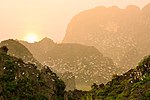
Gallery

 Thung Nham Bird Park
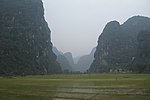 Limestone scenery
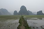 Rice paddies
 Landscape near Ninh Bình
 Tam Cốc-Bích Động
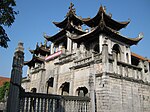
 Hoa Lư - ancient capital
 Khê Hạ village and paddies


.jpg)


Festivals
- Thái Vi festival (Ninh Hải - Hoa Lư) (third moon of the lunar calendar)
- Trường Yên Festival
- Yên Cư Festival
- Nộn Khê Festival
Handicrafts
Embroidered handicrafts in Hoa Lư DistrictSea reed handicrafts in Kim Sơn District
Transportation
Ninh Bình is located 91 km from Hanoi and has both rail and road transport links. It has express rail connections with Hanoi in the north and Thanh Hóa and Vinh in the south. Buses from Hanoi's South Bus Station stop by Ninh Bình; the bus routes parallel and complement the rail route.
Etymology
The province's name derives from Sino-Vietnamese 寧平.