Port Hardy is a district municipality in British Columbia, Canada located on the north-east tip of Vancouver Island.[5] Port Hardy has a population of 3,902 as of the 2021 census.
Port Hardy | |
|---|---|
| District of Port Hardy[1] | |
 Harbour of Port Hardy | |
 Port Hardy  Port Hardy  Port Hardy | |
| Coordinates: 50°43′28″N 127°29′53″W / 50.72444°N 127.49806°W[2] | |
| Country | Canada |
| Province | British Columbia |
| Region | North-Island |
| Regional District | Mount Waddington |
| Incorporated | April 5, 1966[3] |
| Government | |
| • Mayor | Pat Corbett-Labatt[4] |
| Area | |
| • Land | 38.55 km2 (14.88 sq mi) |
| Elevation | 23 m (75 ft) |
| Population (2021) | |
| • Total | 3,902 |
| • Density | 101.2/km2 (262/sq mi) |
| Time zone | UTC−8 (PST) |
| Postal code | V0N |
| Area code(s) | 250, 778 |
| Climate | Cfb |
| Website | porthardy |
It is the gateway to Cape Scott Provincial Park, the North Coast Trail and the BC Marine Trail, located on the northernmost tip of Vancouver Island. The community has access to various outdoor activities, such as kayaking, caving, scuba diving, nature viewing, surfing, saltwater rapids,[6] fishing and camping.
Name
Port Hardy was named after Vice-Admiral Sir Thomas Masterman Hardy, who served as the captain of HMS Victory.[5] He served at the Battle of Trafalgar when Horatio Nelson died in his arms.[7]: 105
Demographics
In the 2021 Census of Population conducted by Statistics Canada, Port Hardy had a population of 3,902 living in 1,791 of its 1,984 total private dwellings, a change of -5.6% from its 2016 population of 4,132. With a land area of 38.55 km2 (14.88 sq mi), it had a population density of 101.2/km2 (262.2/sq mi) in 2021.[8]
Religion
According to the 2021 census, religious groups in Port Hardy included:[9]
- Irreligion (2,715 persons or 70.3%)
- Christianity (995 persons or 25.8%)
- Sikhism (40 persons or 1.0%)
- Buddhism (25 persons or 0.6%)
- Judaism (15 persons or 0.4%)
- Islam (15 persons or 0.4%)
- Indigenous Spirituality (10 persons or 0.3%)
- Other (40 persons or 1.0%)
Ethnicity
| Panethnic group | 2021[9] | 2016[10] | 2011[11] | 2006[12] | 2001[13] | 1996[14] | 1991[15][16] | 1986[17][18][19]: 106 | |||||||||||
|---|---|---|---|---|---|---|---|---|---|---|---|---|---|---|---|---|---|---|---|
| Pop. | % | Pop. | % | Pop. | % | Pop. | % | Pop. | % | Pop. | % | Pop. | % | Pop. | % | ||||
| European[a] | 2,785 | 72.15% | 2,820 | 69.12% | 3,015 | 76.23% | 3,115 | 81.76% | 3,965 | 86.95% | 4,680 | 88.64% | 4,395 | 86.6% | 4,575 | 84.96% | |||
| Indigenous | 800 | 20.73% | 1,055 | 25.86% | 700 | 17.7% | 485 | 12.73% | 460 | 10.09% | 300 | 5.68% | 460 | 9.06% | 415 | 7.71% | |||
| Southeast Asian[b] | 80 | 2.07% | 50 | 1.23% | 60 | 1.52% | 35 | 0.92% | 20 | 0.44% | 105 | 1.99% | 25 | 0.49% | 35 | 0.65% | |||
| East Asian[c] | 75 | 1.94% | 85 | 2.08% | 10 | 0.25% | 65 | 1.71% | 60 | 1.32% | 90 | 1.7% | 70 | 1.38% | 105 | 1.95% | |||
| South Asian | 40 | 1.04% | 15 | 0.37% | 35 | 0.88% | 30 | 0.79% | 20 | 0.44% | 40 | 0.76% | 85 | 1.67% | 180 | 3.34% | |||
| African | 25 | 0.65% | 25 | 0.61% | 15 | 0.38% | 15 | 0.39% | 0 | 0% | 25 | 0.47% | 0 | 0% | 30 | 0.56% | |||
| Latin American | 15 | 0.39% | 15 | 0.37% | 60 | 1.52% | 25 | 0.66% | 0 | 0% | 20 | 0.38% | 30 | 0.59% | 45 | 0.84% | |||
| Middle Eastern[d] | 0 | 0% | 0 | 0% | 0 | 0% | 25 | 0.66% | 0 | 0% | 0 | 0% | 10 | 0.2% | 0 | 0% | |||
| Other/Multiracial[e] | 0 | 0% | 10 | 0.25% | 45 | 1.14% | 10 | 0.26% | 35 | 0.77% | 0 | 0% | — | — | — | — | |||
| Total responses | 3,860 | 98.92% | 4,080 | 98.74% | 3,955 | 98.68% | 3,810 | 99.69% | 4,560 | 99.69% | 5,280 | 99.94% | 5,075 | 99.86% | 5,385 | 99.93% | |||
| Total population | 3,902 | 100% | 4,132 | 100% | 4,008 | 100% | 3,822 | 100% | 4,574 | 100% | 5,283 | 100% | 5,082 | 100% | 5,389 | 100% | |||
| Note: Totals greater than 100% due to multiple origin responses | |||||||||||||||||||
Filomi Days
Once a year, Port Hardy holds a celebration in Rotary Park to acknowledge its natural resource based economy.[20] The three syllables, fi, lo and mi, stand for "fishing, logging and mining".The celebration includes festivities in the park such as activities for children, fundraising concessions, entertainment, beer gardens, bake sales, craft sales, and fireworks.A dance for each age group and a parade are also held on Filomi Days weekend- typically the third weekend in July. Brookes Laidlaw represents the current Vice Admiral in the annual parade.
Tourism

Port Hardy's economy relies greatly on tourism. Ferries to Prince Rupert, another popular tourist destination in British Columbia, depart every other day during peak season.
Tourist traffic in the summer is immense, and hotels and restaurants usually find themselves with no room to accommodate all travellers.[citation needed]
Wildlife
Deer, black bears, bald eagles, squirrels, seals, salmon and many other species of birds and mammals are often spotted along the Quatse Loop Nature Trail or at Storey's Beach which is a short drive from town. Humpback whales can occasionally been seen surfacing in the bay. Port Hardy has many wildlife charters, fishing charters and places to camp during tourist season.
Climate
Port Hardy has an oceanic climate (Köppen Cfb) due to its proximity to the Pacific moderating influence. As a result, summers are very cool for the latitude, whereas winters instead are very mild. Although there is a strong drying trend in summer, its summer rainfall is still higher than those of the southerly mediterranean climates. Winter rainfall is very high and in general Port Hardy is far wetter than Canada's interior.
| Climate data for Port Hardy (Port Hardy Airport) WMO ID: 71109; coordinates 50°40′49″N 127°21′58″W / 50.68028°N 127.36611°W; elevation: 21.6 m (71 ft); 1981−2010 normals, extremes 1944−present | |||||||||||||
|---|---|---|---|---|---|---|---|---|---|---|---|---|---|
| Month | Jan | Feb | Mar | Apr | May | Jun | Jul | Aug | Sep | Oct | Nov | Dec | Year |
| Record high humidex | 14.2 | 16.8 | 19.5 | 22.9 | 35.3 | 31.9 | 30.6 | 32.8 | 28.0 | 25.4 | 18.8 | 15.7 | 35.3 |
| Record high °C (°F) | 13.8 (56.8) | 16.7 (62.1) | 19.8 (67.6) | 23.3 (73.9) | 33.4 (92.1) | 31.7 (89.1) | 26.7 (80.1) | 28.7 (83.7) | 26.8 (80.2) | 25.6 (78.1) | 18.9 (66.0) | 14.8 (58.6) | 33.4 (92.1) |
| Mean daily maximum °C (°F) | 6.5 (43.7) | 7.3 (45.1) | 8.9 (48.0) | 11.2 (52.2) | 13.9 (57.0) | 15.9 (60.6) | 17.8 (64.0) | 18.1 (64.6) | 15.8 (60.4) | 11.8 (53.2) | 8.1 (46.6) | 6.0 (42.8) | 11.8 (53.2) |
| Daily mean °C (°F) | 4.2 (39.6) | 4.4 (39.9) | 5.5 (41.9) | 7.3 (45.1) | 10.1 (50.2) | 12.3 (54.1) | 14.3 (57.7) | 14.4 (57.9) | 12.2 (54.0) | 8.8 (47.8) | 5.5 (41.9) | 3.7 (38.7) | 8.6 (47.5) |
| Mean daily minimum °C (°F) | 1.8 (35.2) | 1.4 (34.5) | 2.0 (35.6) | 3.4 (38.1) | 6.1 (43.0) | 8.7 (47.7) | 10.7 (51.3) | 10.7 (51.3) | 8.5 (47.3) | 5.7 (42.3) | 3.0 (37.4) | 1.3 (34.3) | 5.3 (41.5) |
| Record low °C (°F) | −14.4 (6.1) | −11.8 (10.8) | −12.8 (9.0) | −3.4 (25.9) | −1.5 (29.3) | 1.7 (35.1) | 2.8 (37.0) | 3.3 (37.9) | −1.2 (29.8) | −5.4 (22.3) | −12.5 (9.5) | −12.2 (10.0) | −14.4 (6.1) |
| Record low wind chill | −20 | −23 | −15 | −7 | −4 | 0 | 0 | 0 | −1 | −8 | −21 | −22 | −23 |
| Average precipitation mm (inches) | 247.0 (9.72) | 160.2 (6.31) | 159.7 (6.29) | 125.0 (4.92) | 79.3 (3.12) | 80.7 (3.18) | 53.7 (2.11) | 73.1 (2.88) | 109.6 (4.31) | 256.7 (10.11) | 311.7 (12.27) | 250.9 (9.88) | 1,907.6 (75.10) |
| Average rainfall mm (inches) | 235.0 (9.25) | 151.9 (5.98) | 154.8 (6.09) | 123.5 (4.86) | 79.2 (3.12) | 80.7 (3.18) | 53.7 (2.11) | 73.1 (2.88) | 109.6 (4.31) | 256.5 (10.10) | 307.9 (12.12) | 239.9 (9.44) | 1,865.7 (73.45) |
| Average snowfall cm (inches) | 12.4 (4.9) | 8.8 (3.5) | 4.9 (1.9) | 1.5 (0.6) | 0.1 (0.0) | 0.0 (0.0) | 0.0 (0.0) | 0.0 (0.0) | 0.0 (0.0) | 0.1 (0.0) | 3.9 (1.5) | 10.8 (4.3) | 42.7 (16.8) |
| Average precipitation days (≥ 0.2 mm) | 22.6 | 18.0 | 21.1 | 18.9 | 16.3 | 15.7 | 11.2 | 11.9 | 14.5 | 21.8 | 23.3 | 21.6 | 216.9 |
| Average rainy days (≥ 0.2 mm) | 21.5 | 17.2 | 20.8 | 18.9 | 16.3 | 15.7 | 11.2 | 11.9 | 14.5 | 21.8 | 22.7 | 20.6 | 213.0 |
| Average snowy days (≥ 0.2 cm) | 3.5 | 2.5 | 2.0 | 1.1 | 0.1 | 0.0 | 0.0 | 0.0 | 0.0 | 0.2 | 1.6 | 3.7 | 14.6 |
| Average relative humidity (%) (at 3pm) | 81.8 | 76.6 | 72.9 | 70.0 | 69.6 | 72.2 | 72.6 | 74.8 | 77.8 | 81.1 | 82.5 | 82.6 | 76.2 |
| Mean monthly sunshine hours | 51.4 | 73.9 | 114.2 | 143.2 | 174.7 | 165.8 | 201.8 | 189.2 | 150.0 | 95.5 | 56.3 | 46.3 | 1,462.4 |
| Percent possible sunshine | 19.5 | 26.2 | 31.1 | 34.6 | 36.4 | 33.7 | 40.7 | 42.0 | 39.5 | 28.7 | 20.8 | 18.5 | 31.0 |
| Source: Environment and Climate Change Canada[21][22][23][24][25][26] | |||||||||||||
Radio
- CFNI - 1240 Coast AM
Transportation
Port Hardy is located at the northern end of British Columbia Highway 19, which runs south towards Nanaimo. It is served by the Bear Cove ferry terminal, which sees ferry sailings to Prince Rupert and summer-only service to Bella Coola. Port Hardy Airport has flights to Vancouver on Pacific Coastal Airlines.[27] There are two taxi companies and a public transport bus.
Sister-city relations
 Numata, Hokkaido, Japan since September 1994[28][29][30]

Gallery
 Thunderbird Mall
 Clock tower
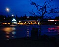
 The Seagate Wharf in Port Hardy
 Carrot Campaign monument
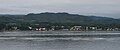 Port Hardy from the water


See also
- Tlatlasikwala Nation
- Da'naxda'xw Awaetlatla Nation (Tanakteuk First Nation)
- Kwakiutl First Nation (Fort Rupert Band)
- Hardy Island Marine Provincial Park
- Penrose Island Marine Provincial Park
Notes
References
External links
- Official website

 Port Hardy travel guide from Wikivoyage