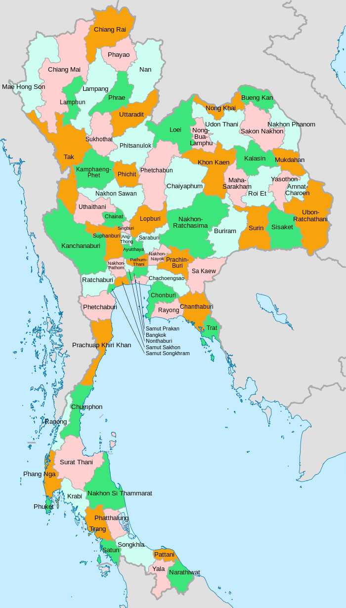
The provinces of Thailand are administrative divisions of the government of Thailand.[3] The country is divided into 76 provinces (Thai: จังหวัด, RTGS: changwat, pronounced [t͡ɕāŋ.wàt̚]) proper, with one additional special administrative area (the capital, Bangkok).[4][5][6] They are the primary local government units and act as juristic persons. They are divided into amphoe (districts) which are further divided into tambon (sub districts), the next lower level of local government.
| Provinces of Thailand | |
|---|---|
| |
| Category | Unitary state |
| Location | Kingdom of Thailand |
| Number | 77 provinces |
| Populations | 174,000 (Mae Hong Son) – 5,702,000 (Bangkok) (2022)[1] |
| Areas | 414 km2 (160 sq mi) Samut Songkhram – 20,736 km2 (8,006 sq mi) Nakhon Ratchasima[2] |
| Government | |
| Subdivisions | |
All provinces form part of the partially devolved central government, or the regional government (ราชการส่วนภูมิภาค ratchakan suan phumiphak). Majority of public services, including police, prison, transport, public relation and others are still overseen and managed by the province on behalf of the central government. In 1938–1996, the Royal Thai Government proposed that each province should have a council, elected from people resided within that province. The council acts as an advisory and auditing body to the governor (ผู้ว่าราชการจังหวัด phu wa ratchakan changwat), who is appointed by the central government. In 1997, each province has its own provincial administrative organization (องค์การบริหารส่วนจังหวัด ongkan borihan suan changwat), presided over by the president. The PAO manages some public services related to the province. It was expected that the PAO president will become the elected governor (instead of a centrally-appointed one), but the full devolution of the government has not happened. The PAO as well as other municipalities form part of the local self-governing government (ราชการส่วนท้องถิ่น ratchakan suan thongthin).
Bangkok, the sole special administrative area, combines the tasks of the provinces with that of a municipality, including having an elected governor.
The 77 provinces in Thailand
| Seal | Name | Name (in Thai) | Population (December 2022)[1] | Area (km2)[2] | Population density | Capital | HS[7] | ISO[8] | FIPS |
|---|---|---|---|---|---|---|---|---|---|
.svg) |  Bangkok Bangkok (special administrative area) | กรุงเทพมหานคร | 5,702,000 | 1,564 | 3,623 | Bangkok | BKK | TH-10 | TH40 |
 |  Amnat Charoen Amnat Charoen | อำนาจเจริญ | 402,000 | 3,290 | 115 | Amnat Charoen | ACR | TH-37 | TH77 |
 |  Ang Thong Ang Thong | อ่างทอง | 301,000 | 950 | 294 | Ang Thong | ATG | TH-15 | TH35 |
 |  Bueng Kan Bueng Kan | บึงกาฬ | 450,000 | 4,003 | 106 | Bueng Kan | BKN | TH-38 | TH81 |
 |  Buriram Buriram | บุรีรัมย์ | 1,623,000 | 10,080 | 159 | Buriram | BRM | TH-31 | TH28 |
 |  Chachoengsao Chachoengsao | ฉะเชิงเทรา | 754,000 | 5,169 | 139 | Chachoengsao | CCO | TH-24 | TH44 |
 |  Chai Nat Chai Nat | ชัยนาท | 331,000 | 2,506 | 131 | Chai Nat | CNT | TH-18 | TH32 |
 |  Chaiyaphum Chaiyaphum | ชัยภูมิ | 1,156,000 | 12,698 | 91 | Chaiyaphum | CPM | TH-36 | TH26 |
.svg) |  Chanthaburi Chanthaburi | จันทบุรี | 572,000 | 6,415 | 84 | Chanthaburi | CTI | TH-22 | TH48 |
 |  Chiang Mai Chiang Mai | เชียงใหม่ | 1,820,000 | 20,107 | 79 | Chiang Mai | CMI | TH-50 | TH02 |
 |  Chiang Rai Chiang Rai | เชียงราย | 1,315,000 | 11,503 | 113 | Chiang Rai | CRI | TH-57 | TH03 |
 |  Chonburi Chonburi | ชลบุรี | 1,603,000 | 4,508 | 346 | Chonburi | CBI | TH-20 | TH46 |
 |  Chumphon Chumphon | ชุมพร | 524,000 | 5,998 | 85 | Chumphon | CPN | TH-86 | TH58 |
 |  Kalasin Kalasin | กาฬสินธุ์ | 1,010,000 | 6,936 | 142 | Kalasin | KSN | TH-46 | TH23 |
 |  Kamphaeng Phet Kamphaeng Phet | กำแพงเพชร | 748,000 | 8,512 | 86 | Kamphaeng Phet | KPT | TH-62 | TH11 |
 |  Kanchanaburi Kanchanaburi | กาญจนบุรี | 914,000 | 19,385 | 46 | Kanchanaburi | KRI | TH-71 | TH50 |
 |  Khon Kaen Khon Kaen | ขอนแก่น | 1,826,000 | 10,659 | 169 | Khon Kaen | KKN | TH-40 | TH22 |
 |  Krabi Krabi | กระบี่ | 500,000 | 5,323 | 90 | Krabi | KBI | TH-81 | TH63 |
 |  Lampang Lampang | ลำปาง | 762,000 | 12,488 | 59 | Lampang | LPG | TH-52 | TH06 |
 |  Lamphun Lamphun | ลำพูน | 421,000 | 4,478 | 92 | Lamphun | LPN | TH-51 | TH05 |
 |  Loei Loei | เลย | 656,000 | 10,500 | 61 | Loei | LEI | TH-42 | TH18 |
 |  Lopburi Lopburi | ลพบุรี | 779,000 | 6,493 | 116 | Lopburi | LRI | TH-16 | TH34 |
 |  Mae Hong Son Mae Hong Son | แม่ฮ่องสอน | 174,000 | 12,765 | 23 | Mae Hong Son | MSN | TH-58 | TH01 |
 |  Maha Sarakham Maha Sarakham | มหาสารคาม | 1,000,000 | 5,607 | 172 | Maha Sarakham | MKM | TH-44 | TH24 |
 |  Mukdahan Mukdahan | มุกดาหาร | 338,000 | 4,126 | 87 | Mukdahan | MDH | TH-49 | TH78 |
 |  Nakhon Nayok Nakhon Nayok | นครนายก | 224,000 | 2,141 | 122 | Nakhon Nayok City | NYK | TH-26 | TH43 |
 |  Nakhon Pathom Nakhon Pathom | นครปฐม | 955,000 | 2,142 | 430 | Mueang Nakhon Pathom | NPT | TH-73 | TH53 |
.svg) |  Nakhon Phanom Nakhon Phanom | นครพนม | 698,000 | 5,637 | 127 | Nakhon Phanom | NPM | TH-48 | TH73 |
 |  Nakhon Ratchasima Nakhon Ratchasima | นครราชสีมา | 2,703,000 | 20,736 | 128 | Nakhon Ratchasima | NMA | TH-30 | TH27 |
 |  Nakhon Sawan Nakhon Sawan | นครสวรรค์ | 997,000 | 9,526 | 111 | Nakhon Sawan | NSN | TH-60 | TH16 |
 |  Nakhon Si Thammarat Nakhon Si Thammarat | นครศรีธรรมราช | 1,602,000 | 9,885 | 158 | Nakhon Si Thammarat | NRT | TH-80 | TH64 |
.svg) |  Nan Nan | น่าน | 492,000 | 12,130 | 40 | Nan | NAN | TH-55 | TH04 |
 |  Narathiwat Narathiwat | นราธิวาส | 847,000 | 4,491 | 180 | Narathiwat | NWT | TH-96 | TH31 |
 |  Nong Bua Lamphu Nong Bua Lamphu | หนองบัวลำภู | 481,000 | 4,099 | 125 | Nong Bua Lam Phu | NBP | TH-39 | TH79 |
 |  Nong Khai Nong Khai | หนองคาย | 536,000 | 3,275 | 160 | Nong Khai | NKI | TH-43 | TH17 |
 |  Nonthaburi Nonthaburi | นนทบุรี | 1,335,000 | 637 | 1,986 | Nonthaburi | NBI | TH-12 | TH38 |
 |  Pathum Thani Pathum Thani | ปทุมธานี | 1,142,000 | 1,520 | 766 | Pathum Thani | PTE | TH-13 | TH39 |
 |  Pattani Pattani | ปัตตานี | 756,000 | 1,977 | 367 | Pattani | PTN | TH-94 | TH69 |
 |  Phang Nga Phang Nga | พังงา | 243,000 | 5,495 | 49 | Phang Nga | PNA | TH-82 | TH61 |
 |  Phatthalung Phatthalung | พัทลุง | 567,000 | 3,861 | 135 | Phatthalung | PLG | TH-93 | TH66 |
 |  Phayao Phayao | พะเยา | 489,000 | 6,189 | 76 | Phayao | PYO | TH-56 | TH41 |
 |  Phetchabun Phetchabun | เพชรบูรณ์ | 1,034,000 | 12,340 | 80 | Phetchabun | PNB | TH-67 | TH14 |
 |  Phetchaburi Phetchaburi | เพชรบุรี | 469,000 | 6,172 | 77 | Phetchaburi | PBI | TH-76 | TH56 |
 |  Phichit Phichit | พิจิตร | 578,000 | 4,319 | 124 | Phichit | PCT | TH-66 | TH13 |
 |  Phitsanulok Phitsanulok | พิษณุโลก | 900,000 | 10,589 | 82 | Phitsanulok | PLK | TH-65 | TH12 |
.svg) |  Phra Nakhon Si Ayutthaya Phra Nakhon Si Ayutthaya | พระนครศรีอยุธยา | 812,000 | 2,548 | 322 | Ayutthaya | AYA | TH-14 | TH36 |
.svg) |  Phrae Phrae | แพร่ | 426,000 | 6,483 | 68 | Phrae | PRE | TH-54 | TH07 |
.png) |  Phuket Phuket | ภูเก็ต | 387,000 | 547 | 762 | Phuket | PKT | TH-83 | TH62 |
 |  Prachinburi Prachinburi | ปราจีนบุรี | 506,000 | 5,026 | 99 | Prachinburi | PRI | TH-25 | TH74 |
 |  Prachuap Khiri Khan Prachuap Khiri Khan | ประจวบคีรีขันธ์ | 530,000 | 6,414 | 88 | Prachuap Khiri Khan | PKN | TH-77 | TH57 |
 |  Ranong Ranong | ระนอง | 204,000 | 3,230 | 60 | Ranong | RNG | TH-85 | TH59 |
 |  Ratchaburi Ratchaburi | ราชบุรี | 895,000 | 5,189 | 168 | Ratchaburi | RBR | TH-70 | TH52 |
 |  Rayong Rayong | ระยอง | 727,000 | 3,666 | 201 | Rayong | RYG | TH-21 | TH47 |
 |  Roi Et Roi Et | ร้อยเอ็ด | 1,295,000 | 7,873 | 166 | Roi Et | RET | TH-45 | TH25 |
 |  Sa Kaeo Sa Kaeo | สระแก้ว | 608,000 | 6,831 | 83 | Sa Kaeo | SKW | TH-27 | TH80 |
 |  Sakon Nakhon Sakon Nakhon | สกลนคร | 1,200,000 | 9,580 | 121 | Sakon Nakhon | SNK | TH-47 | TH20 |
 |  Samut Prakan Samut Prakan | สมุทรปราการ | 1,324,000 | 947 | 1,420 | Mueang Samut Prakan | SPK | TH-11 | TH42 |
 |  Samut Sakhon Samut Sakhon | สมุทรสาคร | 567,000 | 866 | 675 | Mueang Samut Sakhon | SKN | TH-74 | TH55 |
 |  Samut Songkhram Samut Songkhram | สมุทรสงคราม | 209,000 | 414 | 467 | Samut Songkhram | SKM | TH-75 | TH54 |
.png) |  Saraburi Saraburi | สระบุรี | 708,000 | 3,499 | 185 | Saraburi | SRI | TH-19 | TH37 |
 |  Satun Satun | สตูล | 311,000 | 3,019 | 107 | Satun | STN | TH-91 | TH67 |
 |  Sing Buri Sing Buri | สิงห์บุรี | 198,000 | 817 | 255 | Sing Buri | SBR | TH-17 | TH33 |
 |  Sisaket Sisaket | ศรีสะเกษ | 1,484,000 | 8,936 | 165 | Sisaket | SSK | TH-33 | TH30 |
 |  Songkhla Songkhla | สงขลา | 1,444,000 | 7,741 | 186 | Songkhla | SKA | TH-90 | TH68 |
.svg) |  Sukhothai Sukhothai | สุโขทัย | 615,000 | 6,671 | 89 | Sukhothai Thani | STI | TH-64 | TH09 |
 |  Suphan Buri Suphan Buri | สุพรรณบุรี | 891,000 | 5,410 | 156 | Suphan Buri | SPB | TH-72 | TH51 |
 |  Surat Thani Surat Thani | สุราษฎร์ธานี | 1,101,000 | 13,079 | 81 | Surat Thani | SNI | TH-84 | TH60 |
 |  Surin Surin | สุรินทร์ | 1,442,000 | 8,854 | 157 | Surin | SRN | TH-32 | TH29 |
 |  Tak Tak | ตาก | 704,000 | 17,303 | 39 | Tak | TAK | TH-63 | TH08 |
 |  Trang Trang | ตรัง | 636,000 | 4,726 | 136 | Trang | TRG | TH-92 | TH65 |
 |  Trat Trat | ตราด | 218,000 | 2,866 | 78 | Trat | TRT | TH-23 | TH49 |
 |  Ubon Ratchathani Ubon Ratchathani | อุบลราชธานี | 1,903,000 | 15,626 | 120 | Mueang Ubon Ratchathani | UBN | TH-34 | TH75 |
 |  Udon Thani Udon Thani | อุดรธานี | 1,608,000 | 11,072 | 143 | Udon Thani | UDN | TH-41 | TH76 |
 |  Uthai Thani Uthai Thani | อุทัยธานี | 342,000 | 6,647 | 50 | Uthai Thani | UTI | TH-61 | TH15 |
 |  Uttaradit Uttaradit | อุตรดิตถ์ | 470,000 | 7,906 | 58 | Uttaradit | UTD | TH-53 | TH10 |
 |  Yala Yala | ยะลา | 523,000 | 4,476 | 119 | Yala | YLA | TH-95 | TH70 |
 |  Yasothon Yasothon | ยโสธร | 575,000 | 4,131 | 130 | Yasothon | YST | TH-35 | TH72 |
Governance
Thailand's national government organisation is divided into three types: central government (ministries, bureaus and departments), provincial government (provinces and districts) and local government (Bangkok, Pattaya, provincial administrative organisations, etc.).
A province, as part of the provincial government, is administered by a governor (ผู้ว่าราชการจังหวัด) who is appointed by the Minister of Interior. Bangkok, as part of the local government, is administered by a corporation called Bangkok Metropolitan Administration. The corporation is led by the Governor of Bangkok (ผู้ว่าราชการกรุงเทพมหานคร) who is directly elected by the citizens of Bangkok.
The provinces are named after their original main city, which may not necessarily still be the most populous city within the province today. Also, in several provinces the administration has been moved into a new building outside the city.
History
Before 1892
Many provinces date back to semi-independent local chiefdoms or kingdoms, which made up the Ayutthaya Kingdom. The provinces were created around a capital city (mueang), and included surrounding villages or satellite towns. The provinces were administered either by a governor, who was appointed by the king or by a local ruling family, who were descendants of the old kings and princes of that area and had been given this privilege by the central king. De facto the king did not have much choice but to choose someone from the local nobility or an economically strong man, as against these local power groups the administration would have become impossible. The governor was not paid by the king, but instead financed himself and his administration by imposing local taxes himself. Every province was required to send an annual tribute to Bangkok.
The provinces were divided into four different classes. The first-class were the border provinces. The second-class were those that once had their own princely house. Third-class were provinces that were created by splitting them from other provinces. Fourth-class were provinces near the capital. Additionally tributary states like the principalities of Lan Na, the Laotian kingdoms of Vientiane and Luang Prabang, Cambodia, or the Malay sultanate Kedah were also part of the country, but with more autonomy than the provinces. In this Mandala system the semi-independent countries sometimes were tributary to more than one country.
New provinces were created when the population of an area outgrew the administration, but also for political reasons. If a governor became too dominant in a region former satellite cities were elevated to provincial status, as was the case with Maha Sarakham province.
Reforms of the provincial administration started in the 1870s under increased pressure from the colonial states of the United Kingdom and France. Agents were sent, especially to border areas, to impose more control on the provinces or tributary states.
Administrative reform of 1892

At the end of the 19th century King Chulalongkorn reformed the central government. In 1892 the ministry, which previously had many overlapping responsibilities, was reorganized with clear missions as in Western administrations. Prince Damrong Rajanubhab became minister of the Ministry of the North (Mahatthai), originally responsible for the northern administration. When the Ministry of the South (Kalahom) was dissolved in 1894, Prince Damrong became Minister of the Interior, responsible for the provincial administration of the whole country.
Starting in 1893 the already existing commissionaireships in some parts of the country were renamed "superintendent commissioner" (khaluang Thesaphiban), and their area of responsibility was called a monthon. In strategically important areas the monthon were created first, while in other areas the provinces kept their independence a bit longer. Several smaller provinces were reduced in status to an amphoe (district) or even lower to a tambon (sub-district) and included in a neighboring province, sometimes for administrative reasons, but sometimes to remove an uncooperative governor.
In some regions rebellions broke out against the new administrative system, usually induced by the local nobility fearing their loss of power. The most notable was the Holy Man Rebellion in 1902 in Isan. It was initially a messianic doomsday sect, but it also attacked government representatives in the northeast. The provincial town Khemarat was even burned by the rebels. After a few months the rebellion was beaten back.[9]
After 1916, the word changwat became common to use for the provinces, partly to distinguish them from the provincial capital city (mueang or amphoe mueang), but also to stress the new administrative structure of the provinces.[10]

When Prince Damrong resigned in 1915, the whole country was divided into 19 monthon (including the area around Bangkok, which was under the responsibility of another ministry until 1922), with 72 provinces.
In December 1915 King Vajiravudh announced the creation of regions (phak), each administered by a viceroy (upparat), to cover several monthon. Until 1922 four regions were established; however, in 1925 they were dissolved again. At the same time several monthon were merged, in an attempt to streamline administration and reduce costs.
Since 1932
The monthons were dissolved when Thailand transformed from an absolute monarchy into a constitutional monarchy in 1932, making the provinces the top level administrative division again. Several smaller provinces were also abolished at that time. During World War II, several provinces around Bangkok were merged. These changes were undone after the war. Also the occupied area from French Indochina was organized into four provinces: Phra Tabong, Phibunsongkhram, Nakhon Champasak and Lan Chang. The current province of Sukhothai was at first known as Sawankhalok. It was renamed Sukhothai in 1939 (which is why the railway system goes to Sawankhalok city and not Sukhothai city). The province, Kalasin, was reestablished in 1947 after having been dissolved in 1932.
In 1972 Phra Nakhon and Thonburi provinces were merged to form the special administrative area of Bangkok, which combines the tasks of the provinces with that of a municipality, including having an elected governor.
Starting in the second half of the 20th century some provinces were newly created by splitting them off from bigger provinces. In 1975, Yasothon province was split off from Ubon Ratchathani. In 1977, Phayao province was created from districts formerly part of Chiang Rai. In 1982, Mukdahan was split off from Nakhon Phanom. In 1993 three provinces were created: Sa Kaeo (split from Prachinburi), Nong Bua Lamphu province (split from Udon Thani), and Amnat Charoen (split from Ubon Ratchathani). The newest province is Bueng Kan, which was split off from Nong Khai effective 23 March 2011.
Former provinces and administrative areas
Former provinces merged into other provinces
| Province | Capital | Merged in | Fate |
|---|---|---|---|
| Kabin Buri | Kabin Buri | 1926[12] | Merged into Prachinburi province |
| Sukhothai (before 1932) | Sukhothai Thani | 1932[13] | Merged into Sawankhalok province. However, the province's name and location of capital was changed back to Sukhothai in 1938. |
| Lom Sak | Lom Sak | Merged into Phetchabun province | |
| Thanyaburi | Thanyaburi | Merged into Pathum Thani province | |
| Kalasin | Kalasin | Merged into Maha Sarakham province, Split out again in 1947 | |
| Lang Suan | Lang Suan | Merged into Chumphon province | |
| Takua Pa | Takua Pa | Merged into Phang Nga province | |
| Sai Buri | Sai Buri | Merged into Pattani province (except Bacho District which was merged into Narathiwat province) | |
| Phra Pradaeng | Phra Pradaeng | Merged into Samut Prakan province (except Rat Burana District which was merged into Thonburi province) | |
| Min Buri | Min Buri | Merged into Phra Nakhon province (Nong Chok District was merged into Chachoengsao province first then reallocated back in 1933) | |
| Samut Prakan (before 1943) | Samut Prakan | 1943[14] | Merged into Phra Nakhon province (except Ko Sichang District which was merged into Chonburi province). The part of Phra Nakhon was split out again in 1946 |
| Nakhon Nayok | Nakhon Nayok | Merged into Prachinburi province (except Ban Na District which was merged into Saraburi province). Split out again in 1946 | |
| Samut Sakhon | Samut Sakhon | Merged into Thonburi province. Split out again in 1946 | |
| Nonthaburi | Nonthaburi | Merged into Phra Nakhon province (except Bang Kruai District, Bang Yai District, Bang Bua Thong District which was merged into Thonburi province). Split out again in 1946 | |
| Phra Nakhon | Phra Nakhon | 1971[15] | Merged to form the current Bangkok |
| Thonburi | Thonburi |
Lost territories


Map of Siam in early 1893 showing provinces

Historic administrative divisions of Thailand
 Thonburi Administrative Division in 1780 (Sanphet X)
 Rattanakosin Administrative Division in 1800 (Rama I)
 Rattanakosin Administrative Division in 1805 (Rama I)
 Rattanakosin Administrative Division in 1824 (Rama II)
 Rattanakosin Administrative Division in 1837 (Rama III)
 Rattanakosin Administrative Division in 1850 (Rama III)
 Rattanakosin Administrative Division in 1882 (Rama V)
 Rattanakosin Administrative Division in 1890 (Rama V)
 Siamese Administrative Division in 1893 (Rama V)
 Siamese Administrative Division in 1900 (Rama V)
 Siamese Administrative Division in 1906 (Rama V)
 Siamese Administrative Division in 1916 (Rama VI)
 Siamese Administrative Division in 1932 (Rama VII)
 Thai Administrative Division in 1945 (Rama VIII)
 Thai Administrative Division in 1950 (Rama IX)
 Thai Administrative Division in 1973 (Rama IX)
 Thai Administrative Division in 2023 (Rama X)


See also
References
Further reading
- Tej Bunnag (1977). The Provincial Administration of Siam, 1892–1915: the Ministry of the Interior under Prince Damrong Rajanubhab. Kuala Lumpur; New York: Oxford University Press. ISBN 0-19-580343-4.