Subcarpathian Voivodeship is a voivodeship, or province, in the southeastern corner of Poland. Its administrative capital and largest city is Rzeszów. Along with the Marshal, it is governed by the Subcarpathian Regional Assembly. Historically, most of the province's territory was part of the Kingdom of Galicia–Volhynia, the Kingdom of Galicia and Lodomeria and the Ruthenian Voivodeship. In the interwar period, it was part of the Lwów Voivodeship.


.svg)


The voivodeship was created on 1 January 1999 out of the former Rzeszów, Przemyśl, Krosno and (partially) Tarnów and Tarnobrzeg Voivodeships, pursuant to the Polish local-government reforms adopted in 1998. The name derives from the region's location near the Carpathian Mountains, and the voivodeship comprises areas of two historic regions of Eastern Europe — Lesser Poland (western and northwestern counties) and Red Ruthenia. During the interwar period (1918–1939), Subcarpathian Voivodeship belonged to "Poland B", the less-developed, more rural parts of Poland. To boost the local economy, the government of the Second Polish Republic began in the mid-1930s a massive program of industrialization, known as the Central Industrial Region. The program created several major armament factories, including PZL Mielec, PZL Rzeszów, Huta Stalowa Wola, and factories in other Subcarpathian towns such as Dębica, Nowa Dęba, Sanok, Tarnobrzeg and Nowa Sarzyna.
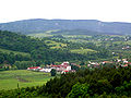
It is bordered by Lesser Poland Voivodeship to the west, Świętokrzyskie Voivodeship to the north-west, Lublin Voivodeship to the north, Ukraine (Lviv Oblast and Zakarpattia Oblast) to the east and Slovakia (Prešov Region) to the south. It covers an area of 17,844 square kilometres (6,890 sq mi), and has a population of 2,127,462 (as at 2019). The voivodeship is mostly hilly or mountainous (see Bieszczady, Beskidy); its northwestern corner is flat. It is one of the most wooded Polish voivodeships (35.9% of total area), within its borders there is whole Bieszczady National Park, and parts of Magura National Park.
History
Government
Subcarpathian Voivodeship's government powers are shared between the voivode (governor), the sejmik (regional assembly), and the marshal.
Cities and towns
The voivodeship contains 6 cities and 45 towns. These are listed below in descending order of population (according to official figures as of 2019)[3]
- Rzeszów (194,886)
- Przemyśl (60,999)
- Stalowa Wola (60,799)
- Mielec (60,366)
- Tarnobrzeg (46,907)
- Krosno (46,369)
Towns:
- Dębica (45,634)
- Jarosław (37,585)
- Sanok (37,381)
- Jasło (35,063)
- Łańcut (17,709)
- Ropczyce (15,836)
- Przeworsk (15,356)
- Nisko (15,324)
- Leżajsk (13,853)
- Sędziszów Małopolski (12,357)
- Lubaczów (12,018)
- Nowa Dęba (11,152)
- Ustrzyki Dolne (9,097)
- Kolbuszowa (9,075)
- Strzyżów (8,884)
- Brzozów (7,463)
- Rudnik nad Sanem (6,710)
- Głogów Małopolski (6,654)
- Boguchwała (6,179)
- Dynów (6,129)
- Nowa Sarzyna (5,834)
- Jedlicze (5,736)
- Lesko (5,424)
- Radymno (5,279)
- Zagórz (5,095)
- Pilzno (4,912)
- Sokołów Małopolski (4,193)
- Rymanów (3,825)
- Tyczyn (3,824)
- Pruchnik (3,764)
- Radomyśl Wielki (3,231)
- Kańczuga (3,167)
- Zaklików (2,979)
- Oleszyce (2,974)
- Brzostek (2,752)
- Sieniawa (2,140)
- Błażowa (2,139)
- Narol (2,109)
- Dukla (2,061)
- Cieszanów (1,913)
- Iwonicz-Zdrój (1,787)
- Przecław (1,775)
- Baranów Sandomierski (1,456)
- Ulanów (1,422)
- Kołaczyce (1,409)
- Dubiecko (866)
Administrative division
Subcarpathian Voivodeship is divided into 25 counties (powiats): 4 city counties and 21 land counties. These are further divided into 160 gminas.
The counties are listed in the following table (ordering within categories is by decreasing population).
| English and Polish names | Area | Population (2019) | Seat | Other towns | Total gminas | |
| km2 | sq mi | |||||
| City counties | ||||||
| Rzeszów | 77 | 30 | 194,886 | 1 | ||
| Przemyśl | 44 | 17 | 60,999 | 1 | ||
| Tarnobrzeg | 86 | 33 | 46,907 | 1 | ||
| Krosno | 43 | 17 | 46,369 | 1 | ||
| Land counties | ||||||
| Rzeszów County powiat rzeszowski | 471 | 182 | 168,614 | Rzeszów * | Boguchwała, Głogów Małopolski, Sokołów Małopolski, Błażowa, Tyczyn | 14 |
| Mielec County powiat mielecki | 880 | 340 | 136,591 | Mielec | Radomyśl Wielki, Przecław | 10 |
| Dębica County powiat dębicki | 776 | 300 | 135,348 | Dębica | Pilzno, Brzostek | 7 |
| Jarosław County powiat jarosławski | 1,029 | 397 | 120,462 | Jarosław | Radymno, Pruchnik | 11 |
| Jasło County powiat jasielski | 830 | 320 | 113,730 | Jasło | Kołaczyce | 10 |
| Krosno County powiat krośnieński | 924 | 357 | 112,301 | Krosno * | Jedlicze, Rymanów, Dukla, Iwonicz-Zdrój | 10 |
| Stalowa Wola County powiat stalowowolski | 833 | 322 | 106,272 | Stalowa Wola | Zaklików | 6 |
| Sanok County powiat sanocki | 1,225 | 473 | 94,473 | Sanok | Zagórz | 8 |
| Łańcut County powiat łańcucki | 452 | 175 | 80,898 | Łańcut | 7 | |
| Przeworsk County powiat przeworski | 698 | 269 | 78,354 | Przeworsk | Kańczuga, Sieniawa | 9 |
| Ropczyce-Sędziszów County powiat ropczycko-sędziszowski | 549 | 212 | 74,416 | Ropczyce | Sędziszów Małopolski | 5 |
| Przemyśl County powiat przemyski | 1,214 | 469 | 74,234 | Przemyśl * | Dubiecko | 10 |
| Leżajsk County powiat leżajski | 583 | 225 | 69,479 | Leżajsk | Nowa Sarzyna | 5 |
| Nisko County powiat niżański | 786 | 303 | 66,699 | Nisko | Rudnik nad Sanem, Ulanów | 7 |
| Brzozów County powiat brzozowski | 540 | 210 | 65,652 | Brzozów | 6 | |
| Kolbuszowa County powiat kolbuszowski | 774 | 299 | 62,389 | Kolbuszowa | 6 | |
| Strzyżów County powiat strzyżowski | 503 | 194 | 61,505 | Strzyżów | 5 | |
| Lubaczów County powiat lubaczowski | 1,308 | 505 | 55,438 | Lubaczów | Oleszyce, Narol, Cieszanów | 8 |
| Tarnobrzeg County powiat tarnobrzeski | 520 | 200 | 53,115 | Tarnobrzeg * | Nowa Dęba, Baranów Sandomierski | 4 |
| Lesko County powiat leski | 835 | 322 | 26,532 | Lesko | 5 | |
| Bieszczady County powiat bieszczadzki | 1,138 | 439 | 21,799 | Ustrzyki Dolne | 3 | |
| * seat not part of the county | ||||||
Protected areas

Protected areas in Subcarpathian Voivodeship include two national parks and 11 Landscape Parks. These are listed below.
- Bieszczady National Park (part of the East Carpathian Biosphere Reserve)
- Magura National Park (partly in Lesser Poland Voivodeship)
- Cisna-Wetlina Landscape Park
- Czarnorzeki-Strzyżów Landscape Park
- Jaśliska Landscape Park
- Janów Forests Landscape Park (partly in Lublin Voivodeship)
- Pasmo Brzanki Landscape Park (partly in Lesser Poland Voivodeship)
- Pogórze Przemyskie Landscape Park
- Puszcza Solska Landscape Park (partly in Lublin Voivodeship)
- San Valley Landscape Park
- Słonne Mountains Landscape Park
- South Roztocze Landscape Park (partly in Lublin Voivodeship)
Economy
The Gross domestic product (GDP) of the province was 19.4 billion euros in 2018, accounting for 3.9% of Polish economic output. GDP per capita adjusted for purchasing power was 15,100 euros or 50% of the EU27 average in the same year. The GDP per employee was 59% of the EU average. Podkarpackie Voivodship is the province with the third lowest GDP per capita in Poland.[4]
Ethnic groups
Population according to 2002 census[5]

Most popular surnames in the region
Notable residents
- Moe Drabowsky, American major league baseball pitcher
- Stefan Turchak, Ukrainian conductor
Subcarpathia landscape pictures
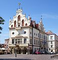 Rzeszów town hall


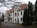 Jasło Palace
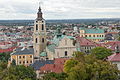
 Royal Casimir Castle in Przemyśl
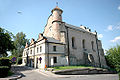 Lesko synagogue
 Tarnowski Palace in Tarnobrzeg
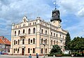 Jarosław town hall

 Solina seen from the distance
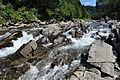 Wetlina River


 Open air museum in Sanok
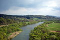
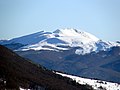 Tarnica Mountain
 A historic oil well
 Leopard car
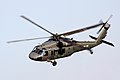 Black Hawk helicopters are produced by PZL Mielec
 Autosan bus and coach manufacturer has its headquarters in Sanok
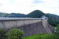 Solina Dam is the largest dam in Poland


.jpg)

.jpg)


See also
References
- "Central Statistical Office(GUS) - TERYT(National Register of Territorial Land Apportionment Journal)".
 (in Polish). 2008-01-09. Retrieved 2008-10-23.

Notes
External links
- Subcarpathia photo gallery
- (in Polish) Subcarpathian Voivodeship official website
- (in Polish) Podkarpacki Urząd Wojewódzki Official website
- (in English) The castles and palaces of Subcarpathian province