

Սկզբնական նիշք (SVG-նիշք, անվանապես 976 × 818 փիքսել, նիշքի չափը՝ 949 ԿԲ)
Այս նիշքը տեղադրված է Վիքիպահեստում է և այն կարող է օգտագործվել այլ նախագծերի կողմից։Վիքիպահեստում նիշքի մասին տեղեկությունների հիմնական մասը ներկայացված է ստորև։
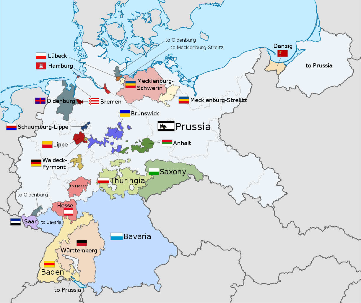
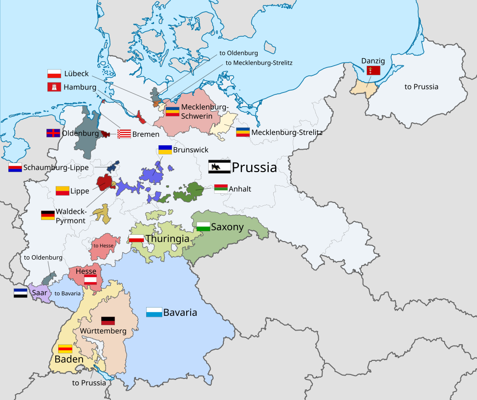
| ՆկարագրումWeimar Republic states map.svg | English: A map of the states of the Weimar Republic, showing their location, flags and names in English. |
| Թվական | |
| Աղբյուր | This file was derived from : Weimar Republic blank map.svg: This vector image includes elements that have been taken or adapted from this file: This vector image includes elements that have been taken or adapted from this file: This vector image includes elements that have been taken or adapted from this file: This vector image includes elements that have been taken or adapted from this file: This vector image includes elements that have been taken or adapted from this file: This vector image includes elements that have been taken or adapted from this file: This vector image includes elements that have been taken or adapted from this file: This vector image includes elements that have been taken or adapted from this file: This vector image includes elements that have been taken or adapted from this file: This vector image includes elements that have been taken or adapted from this file: This vector image includes elements that have been taken or adapted from this file: This vector image includes elements that have been taken or adapted from this file: This vector image includes elements that have been taken or adapted from this file: This vector image includes elements that have been taken or adapted from this file: This vector image includes elements that have been taken or adapted from this file: This vector image includes elements that have been taken or adapted from this file: |
| Հեղինակ |
|
| Այլ մեկնակերպներ |
|
| SVG genesis InfoField | Այս մասշտաբավորելի վեկտորային գրաֆիկայի նիշքի ելակետային կոդը վավեր է. Սա վեկտոր գրաֆիկական պատկեր է ստեղծված է եղել Inkscape օգնությամբ: . This flag uses embedded text that can be easily translated using a text editor. |

Մատնահարեք օրվան/ժամին՝ նիշքի այդ պահին տեսքը դիտելու համար։
| Օր/Ժամ | Մանրապատկեր | Օբյեկտի չափը | Մասնակից | Մեկնաբանություն | |
|---|---|---|---|---|---|
| ընթացիկ | 22:22, 17 Դեկտեմբերի 2021 | | 976 × 818 (949 ԿԲ) | Alphathon | Corrections to Anhalt and Brunswick |
| 03:28, 5 Նոյեմբերի 2015 |  | 976 × 818 (981 ԿԲ) | Alphathon | {{Information |Description={{en|A map of the states of the en:Weimar Republic, showing their location, flags and names in English.}}{{Valid SVG}} |Source={{Derived from|File:Weimar Republic blank map.svg|display=50}} {{AttribSVG|Flag of Prussia (... |
Հետևյալ էջը հղվում է այս նիշքին՝
Հետևյալ այլ վիքիները օգտագործում են այս նիշքը՝
Նիշքը պարունակում է ընդարձակ տվյալները, հավանաբար ավելացված թվային լուսանկարչական ապարատի կամ սկաների կողմից, որոնք օգտագործվել են նկարը ստեղծելու կամ թվայնացնելու համար։
Եթե նիշքը ձևափոխվել է ստեղծումից ի վեր, ապա որոշ տվյալները կարող են չհամապատասխանել ձևափոխված նիշքին։
| Width | 975.66052 |
|---|---|
| Height | 817.62897 |


.svg)


.svg)
.svg)
.svg)
.svg)