

اصل فائل (ایس وی جی فائل، پکسل:۹۰۰ × ۹۰۰، فائل سائز: ۱۰۲ کلوبائٹ)
ایہ فائل Wikimedia Commons توں اے تے دوجیاں ویونتاں تے وی ورتی جاسکدی اے۔گل بات اس دے فائل گل بات صفحہ تے تھلے دتی گئی۔
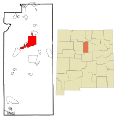
| تفصیلSanta Fe County New Mexico Incorporated and Unincorporated areas Santa Fe Highlighted.svg | This map shows the incorporated and unincorporated areas in Santa Fe County, New Mexico, highlighting Santa Fe in red. It was created with a custom script with US Census Bureau data and modified with Inkscape. |
| تریخ | |
| سروت | My own work, based on public domain information. Based on similar map concepts by Ixnayonthetimmay |
| لکھاری | Arkyan |
 | کاپی کرن، ونڈن تے بدلن دی ایس ڈوکومنٹ لئی اجازت دتی جاندی اے ایہناں GNU Free Documentation License, Version 1.2 شرطاں نال یا مگروں کسے وی چھپے ورین Free Software Foundation توں بنا کسے انویرینٹ سیکشن دے، ناں فرنٹ کور لکھت تے ناں بیک کور لکھت دے۔ لسنس دی اک کاپی سیکشن وچ ہیگی اے جہدا ناں اے GNU Free Documentation License۔http://www.gnu.org/copyleft/fdl.htmlGFDLGNU Free Documentation Licensetruetrue |
| ایس فائل نوں کریٹو کامنز Attribution 2.5 پولینڈ لائسنس دتا گیا. | ||
| ||
| اس لائسنس دا ٹیگ GFDL دے مطابق اس فائل چ پایا گیا اے licensing update۔http://creativecommons.org/licenses/by-sa/3.0/CC BY-SA 3.0Creative Commons Attribution-Share Alike 3.0truetrue |
فائل نو اس ویلے دی حالت وچ ویکھن واسطے تاریخ/ویلے تے کلک کرو۔
| تریخ تے ویلہ | نکی مورت | پاسے | ورتن والا | تیپّݨی کرو | |
|---|---|---|---|---|---|
| موجودہ | ۰۱:۵۷, ۲۶ اکتوبر ۲۰۰۷ | | ۹۰۰ × ۹۰۰ (۱۰۲ کلوبائٹ) | ArkyBot~commonswiki | {{Information |Description=This map shows the incorporated and unincorporated areas in Santa Fe County, New Mexico, highlighting Santa Fe in red. |
تھلے دتے گئے 1 صفحے اس فائل نال جُڑدے نیں
ایہہ دوجے وکیاں ایس فائل نوں ورتدے نیں –
ایس فائل دا ویکھو ہور جگت ورتن .