

Tập tin gốc (3.400×4.600 điểm ảnh, kích thước tập tin: 1,47 MB, kiểu MIME: image/jpeg)
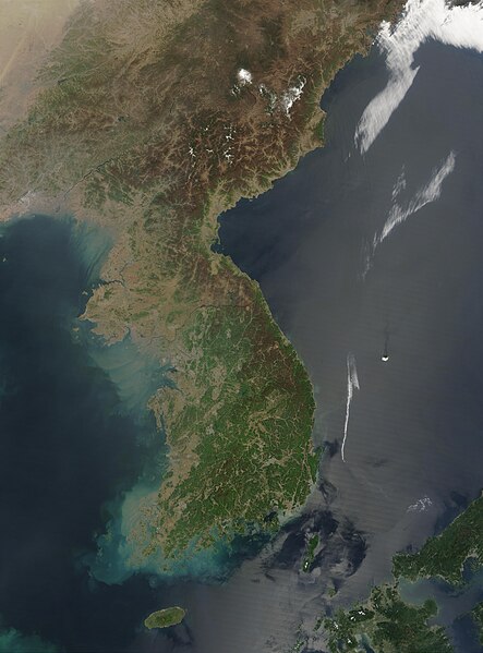
| Miêu tảKorea 2003-05-01 NASA MODIS Terra 250m.jpg | Français : Image satellite de la Corée le 1er mai 2003 par le satellite Terra du programme MODIS de la NASA, résolution 250m English: This Moderate Resolution Imaging Spectroradiometer (MODIS) image from May 1, 2003, shows southeastern China (top), North Korea (center) and South Korea (bottom). The higher elevations and more northern latitudes are lagging behind the new growth of spring vegetation visible across South Korea. Large areas of North Korea, especially the western coast, are deforested, probably contributing to the large volumes of sediment run-off swirling in the coastal waters. A few scattered fires have been marked with red dots. Resolution 250m |
| Ngày | |
| Nguồn gốc | NASA's Visible Earth, https://visibleearth.nasa.gov/images/66392/korea |
| Tác giả | Jeff Schmaltz, MODIS Rapid Response Team, NASA/GSFC |
| Vị trí máy chụp hình | 38° 17′ 49,42″ B, 127° 06′ 58,5″ Đ | Xem hình này và các hình ảnh lân cận trên: OpenStreetMap |
|---|
| Public domainPublic domainfalsefalse |
| This file is in the public domain in the United States because it was solely created by NASA. NASA copyright policy states that "NASA material is not protected by copyright unless noted". (See Template:PD-USGov, NASA copyright policy page or JPL Image Use Policy.) | ||
 | Warnings:
|
Nhấn vào ngày/giờ để xem nội dung tập tin tại thời điểm đó.
| Ngày/giờ | Hình xem trước | Kích cỡ | Thành viên | Miêu tả | |
|---|---|---|---|---|---|
| hiện tại | 07:18, ngày 25 tháng 9 năm 2023 | | 3.400×4.600 (1,47 MB) | Koreller | Uploaded own work with UploadWizard |
Những wiki sau đang sử dụng tập tin này:
Xem thêm các trang toàn cục sử dụng tập tin này.