Jump to content

Mount Auburn, Iowa

92°5′34″W / 42.25722°N 92.09278°W / 42.25722; -92.09278
From Simple English Wikipedia, the free encyclopedia
Mount Auburn, Iowa
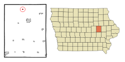
Location of Mount Auburn, Iowa
Coordinates: 42°15′26″N 92°5′34″W / 42.25722°N 92.09278°W / 42.25722; -92.09278
Country United States
State Iowa
CountyBenton
Area
 • Total0.25 sq mi (0.64 km2)
 • Land0.25 sq mi (0.64 km2)
 • Water0.00 sq mi (0.00 km2)
Elevation
879 ft (268 m)
Population
 • Total162
 • Density655.6/sq mi (253.13/km2)
Time zoneUTC-6 (Central (CST))
 • Summer (DST)UTC-5 (CDT)
ZIP code
52313
Area code319
FIPS code19-54435
GNIS feature ID0459272

Mount Auburn is a city in Iowa in the United States. The population was 162 in 2020 census[2]

Referenceschange source

🔥 Top keywords: Main PageSpecial:SearchModule:Track gauge/dataSOLID (object-oriented design)Wikipedia:AboutHelp:ContentsHelp:IntroductionSpecial:RecentChangesPornhubBlackAdolf Hitler UunonaFile:ASCII-Table-wide.svgList of constituencies of the Lok SabhaList of U.S. states and territories by time zoneSchrödinger's catList of U.S. states by date of admission to the UnionFile:Sexual intercourse with internal ejaculation.webmHeera MandiList of people who have walked on the MoonDavid24-hour clockModule:Emoji/dataLawrence WongCristiano RonaldoPeriodic tableList of countries by areaUnited StatesCategory:2000s American music groupsList of U.S. statesBismillahir Rahmanir RaheemList of fruitsQueen (band)Special:MyTalkXXXTentacionWikipedia:Contact usHelp:Authority controlWikipedia:Simple talkList of countries by continentsWikipedia:Simple start