New South Wales
New South Wales is one of the states of Australia. It is the oldest state in Australia and is sometimes called the "Premier State". Of all Australian states, New South Wales has the most people. The capital city of New South Wales is Sydney. Sydney is the biggest city in Australia.
| New South Wales | |||||
|---|---|---|---|---|---|
| |||||
| Slogan or nickname | The First State The Premier State | ||||
| Motto(s) | Orta Recens Quam Pura Nites (Newly Risen, How Brightly You Shine) | ||||
 Other Australian states and territories | |||||
| Capital city | Sydney | ||||
| Government | Constitutional monarchy | ||||
| • Governor | Margaret Beazley | ||||
| • Premier | Chris Minns (Labor) | ||||
| Australian state | |||||
| • Established as Colony | 26 January 1788 | ||||
| • Responsible government | 6 June 1856 | ||||
| • Became Australian state | 1 January 1901 | ||||
| • Australia Act | 3 March 1986 | ||||
| Area | |||||
| • Total | 809,444 km² (5th) 312,528 sq mi | ||||
| • Land | 800,642 km² 309,130 sq mi | ||||
| • Water | 8,802 km² (1.09%) 3,398 sq mi | ||||
| Population (March 2019)[1] | |||||
| • Population | 8,071,071 (1st) | ||||
| • Density | 10.08/km² (3rd) 26.1 /sq mi | ||||
| Elevation | |||||
| • Highest point | Mount Kosciuszko 2,228 m (7,310 ft) | ||||
| Gross state product (2017–18) | |||||
| • Product ($m) | $593,275[2] (1st) | ||||
| • Product per capita | $74,955 (3rd) | ||||
| Time zone(s) | UTC+10 (AEST) UTC+11 (AEDT) UTC+9:30 (ACST) (Broken Hill) UTC+10:30 (ACDT) (Broken Hill) UTC+10:30 (LHST) (Lord Howe Island) UTC+11:00 (LHDT) (Lord Howe Island) | ||||
| Federal representation | |||||
| • House seats | 48/150 | ||||
| • Senate seats | 12/76 | ||||
| Abbreviations | |||||
| • Postal | NSW | ||||
| • ISO 3166-2 | AU-NSW | ||||
| Emblems | |||||
| • Floral | Waratah (Telopea speciosissima)[3] | ||||
| • Animal | Platypus (Ornithorhynchus anatinus) | ||||
| • Bird | Kookaburra (Dacelo gigas) | ||||
| • Fish | Blue groper (Achoerodus viridis) | ||||
| • Mineral or gemstone | Black Opal | ||||
| • Fossil | Mandageria fairfaxi | ||||
| • Colours | Sky blue (Pantone 291)[4] | ||||
| Website | www | ||||
| Footnotes | Coordinates[5] Emblems[6] | ||||


New South Wales was named by Lieutenant James Cook (later Captain Cook), who sailed up the east coast of Australia in 1770.
New South Wales was founded (begun) in 1788, by the British who set up a small penal colony on the land of various Aboriginal tribes who had been there for tens of thousands of years. The British colony of New South Wales originally included more than half of the Australian mainland, as well as New Zealand, Lord Howe Island and Norfolk Island. During the 19th century large areas were separated to form the British colonies of Tasmania, South Australia, Victoria, Queensland and New Zealand.
Geography
New South Wales has four main geographical areas:
- A coastal strip, which runs the whole length of the coast from the Queensland border to the Victorian border. In some places this is a wide plain. In other places it is just a very narrow strip of land between mountains and the sea. The regions of the coastal strip are the North Coast (which borders with Queensland), the Central Coast, the Newcastle region, the Sydney region (which is called the Cumberland Plain), the Illawarra (which is the region around the city of Wollongong) and the Shoalhaven around Nowra.
- The climate of this area ranges from cool temperate on the far south coast to subtropical near the Queensland border. This whole of the coastal strip is affected by the sea. For this reason, the temperatures are often cooled in the summer by sea breezes, and warmed in the winter by the currents along the coast. This makes the climate less hot and less cold than that of the inland regions. There is also more rain than there is farther inland where it is often very dry. For this reason, the three largest cities are all on the coast. The coast also has more intensive agriculture than the inland areas, with dairy cattle and vegetables crops, as well as sugar cane and bananas in the north.
- The mountainous areas of the Great Dividing Range and the high country around them run parallel to the coast from Queensland to Victoria. This includes the New England region, the Central Tablelands, the Blue Mountains near Sydney, the Southern Highlands and the Snowy Mountains.
- The agricultural plains fill a big portion of the state's area, with many fewer people than the coast, includes the Riverina area around Wagga Wagga.
- The dry plains in the far north-west of the state, have a few small communities.
The state is bordered on the north by Queensland, on the west by South Australia, and on the south by Victoria. Its coast faces the Tasman Sea. New South Wales contains two Federal Territories: the Australian Capital Territory (ACT), and the Jervis Bay Territory.
New South Wales' three big cities are Sydney, Newcastle and Wollongong which all lie along the coast. Other big towns include Albury which borders with Victoria; Broken Hill, the most westerly large town; Dubbo; Orange, Bowral, Bathurst, home of the Bathurst 1000; Port Macquarie, Tamworth, home to the country music festival; Armidale, Inverell, Lismore, Nowra, Gosford, Griffith, Queanbeyan, Leeton, Wagga Wagga, Goulburn, where a lot of Australia's fruit is grown and Coffs Harbour, a popular tourist destination.
Demographics
The population of New South Wales at the end of June 2007 was 6.89 million people. Population grew by 1.1% over the preceding year,[7] lower than the national rate of 1.5%.
62.9% of NSW's population is based in Sydney.[8]


| Rank | Statistical division/district | June 2007 population[9] |
|---|---|---|
| 1 | Sydney | 4,336,374 |
| 2 | Newcastle | 523,662 |
| 3 | Wollongong | 280,159 |
| 4 | Wagga Wagga | 56,147 |
| 5 | Tweed Heads | 50,726 |
| 6 | Coffs Harbour | 50,726 |
| 7 | Tamworth | 44,970 |
| 8 | Albury | 44,787 |
| 9 | Port Macquarie | 42,042 |
| 10 | Orange | 37,333 |
| 11 | Queanbeyan | 36,331 |
| 12 | Dubbo | 36,150 |
| 13 | Nowra-Bomaderry | 32,556 |
| 14 | Bathurst | 32,385 |
| 15 | Lismore | 31,865 |
Gallery
 The City of Sydney seen from Taronga Park Zoo
 The Sydney Royal Easter show is a popular annual event.
 Boolominbah at Armidale is one of the finest examples of Federation architecture in New South Wales.
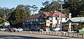 The pub and general store at Ourimbah show a scene which is familiar in most towns.
 Ninety Mile Beach
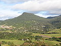 Mount Kembla rises above the narrow coastal plain at Wollongong.
 The Three Sisters are a famous landmark in the Blue Mountains.
 The Murrumbidgee River flows through Wagga Wagga.
 Crystal Shower Falls in Dorrigo National Park
 Beef cattle and sheep are major industries in the agricultural plains.
 Grain storage silos near Newcastle
 Dams are used to store water and generate power.


References
- australian-post-codes.com Postcode Search Archived 2010-07-16 at the Wayback Machine
Other websites
- Postcode Tool – New South Wales Archived 2007-12-14 at the Wayback Machine