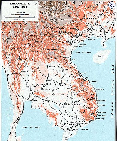
Gambar:Indochina 1954.jpg

Berkas asli (701 × 845 piksel, ukuran koropak: 175 KB, tipeu MIME: image/jpeg)
- Description: Indochina 1954
- Source: www.dean.usma.edu
- Background information:
In 1938 the predecessors of what is today The Department of History at the United States Military Academy began developing a series of campaign atlases to aid in teaching cadets a course entitled, "History of the Military Art." Since then, the Department has produced over six atlases and more than one thousand maps, encompassing not only America’s wars but global conflicts as well.
In keeping abreast with today's technology, the Department of History is providing these maps on the internet as part of the department's outreach program. The maps were created by the United States Military Academy’s Department of History and are the digital versions from the atlases printed by the United States Defense Printing Agency. We gratefully acknowledge the accomplishments of the department's former cartographer, Mr. Edward J. Krasnoborski, along with the works of our present cartographer, Mr. Frank Martini.
Please be aware that these maps are large in file size and may require substantial download times.
Berkas ini merupakan hasil karya dari personel atau pegawai Angkatan Darat Amerika Serikat yang dibuat sebagai bagian dari tugas mereka sehingga berkas ini memiliki lisensi domain publik karena merupakan sebuah karya dari Pemerintah Federal Amerika Serikat. |  |
Jujutan berkas
Klik dina titimangsa pikeun nempo koropak nu aya dina mangsa éta.
| Titimangsa | Miniatur | Ukuran | Pamaké | Kamandang | |
|---|---|---|---|---|---|
| kiwari | 28 Juni 2005 16.30 | | 701 × 845 (175 KB) | W.wolny |
Pamakéan berkas
Ieu berkas dipaké ku kaca di handap:
Pamakéan berkas sajagat
Wiki lianna anu maké ieu berkas:
- Pamakéan di azb.wikipedia.org
- Pamakéan di de.wikipedia.org
- Pamakéan di en.wikipedia.org
- Pamakéan di eo.wikipedia.org
- Pamakéan di eo.wikiquote.org
- Pamakéan di es.wikipedia.org
- Pamakéan di is.wikipedia.org
- Pamakéan di km.wikipedia.org
- Pamakéan di nl.wikipedia.org
_2020.svg)