Файл:Dust Storm Over Turkmenistan.jpg

Розмір при попередньому перегляді: 800 × 531 пікселів. Інші роздільності: 320 × 212 пікселів | 640 × 425 пікселів | 1024 × 680 пікселів | 1280 × 850 пікселів | 3072 × 2039 пікселів.
Повна роздільність (3072 × 2039 пікселів, розмір файлу: 911 КБ, MIME-тип: image/jpeg)
| Відомості про цей файл містяться на Вікісховищі — централізованому сховищі вільних файлів мультимедіа для використання у проектах Фонду Вікімедіа. |
Опис файлу
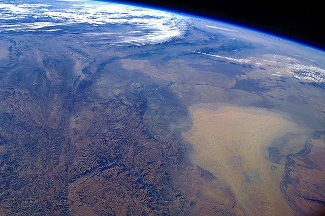
| Опис | English: This west-looking astronaut photograph, taken with a short focal length lens from the International Space Station, spans a wide swath of central Asia—from Afghanistan, along the length of Turkmenistan, and beyond to the Caspian Sea. Winds blowing down the largest river valley in the region, the Amudarya, were strong enough to raise a large dust storm. Dust appears as a light brown mass extending into the center of the image from the lower right. Diffuse dust from prior windy weather appears over much of the area making a regional haze that hides landscape details. The haze partly obscures the irrigated agriculture in Turkmenistan and entirely obscures the Caspian Sea. Numerous rivers rise in the Hindu Kush range (lower left). The Band-i Amir River is a major tributary of the main regional river, the Amudarya, which it reaches via a deep canyon. The Amudarya River was the major historical contributor of water to the Aral Sea, but today extensive diversion of river water for agricultural purposes has led to desiccation of the sea bed. The exposed sea bed is a major source of saline dusts contaminated with agricultural chemicals, and it poses a significant environmental and human health hazard to central Asia. To a lesser extent, dusts are also mobilized from sediments along the Amudarya River channel. The Paropamisus Range and the Amudarya (also known as the Oxus River) are mentioned in histories of Alexander the Great’s famous military expedition from Greece to India. His horsemen are described as having made a fast side excursion from near the Caspian Sea (image top right) as far as the Amudarya (image lower right).
| ||||||||||||||||||||||||||||||||||||||||||||||||||
| Час створення | |||||||||||||||||||||||||||||||||||||||||||||||||||
| Джерело | NASA Earth Observatory | ||||||||||||||||||||||||||||||||||||||||||||||||||
| Автор | This image was taken by the NASA Expedition 17 crew. | ||||||||||||||||||||||||||||||||||||||||||||||||||
| Місцеположення камери | | Перегляньте це та інші зображення поблизу на: OpenStreetMap |
|---|
Astronaut photograph ISS017-E-19616 was taken with a Nikon D2Xs digital camera fitted with a 28 mm lens, and is provided by the ISS Crew Earth Observations experiment and Image Science & Analysis Laboratory, Johnson Space Centre.
Це зображення або відео внесене у каталог Космічного центру Ліндона Джонсона Національного управління з аеронавтики і дослідження космічного простору США (NASA)під фото ID: ISS017-E-19616. Це не тег авторських прав. Дійсна ліцензія має додаватись до цього тегу. Інші мови: |
Ліцензування
| Цей файл перебуває у суспільному надбанні, оскільки він був створений NASA (Національним управлінням з аеронавтики і дослідження космічного простору). Згідно з політикою NASA стосовно авторського права, «матеріали NASA не захищаються авторським правом, якщо не вказано протилежне». (Див. Template:PD-USGov, сторінку політики NASA стосовно авторського права, або політику використання зображень JPL.) | ||
 | Попередження:
|
Історія файлу
Клацніть на дату/час, щоб переглянути, як тоді виглядав файл.
| Дата/час | Мініатюра | Розмір об'єкта | Користувач | Коментар | |
|---|---|---|---|---|---|
| поточний | 09:39, 18 січня 2011 | | 3072 × 2039 (911 КБ) | Originalwana | higher res |
| 14:56, 26 квітня 2009 |  | 1440 × 960 (597 КБ) | Originalwana | {{Information |Description={{en|1=This west-looking astronaut photograph, taken with a short focal length lens from the International Space Station, spans a wide swath of central Asia—from Afghanistan, along the length of Turkmenistan, and beyond to the |
Використання файлу
Такі сторінки використовують цей файл:
Глобальне використання файлу
Цей файл використовують такі інші вікі:
- Використання в bn.wikipedia.org
- Використання в en.wikipedia.org
- Використання в en.wikiquote.org
- Використання в id.wikipedia.org
- Використання в it.wikipedia.org
- Використання в kn.wikipedia.org
- Використання в ms.wikipedia.org
- Використання в sq.wikipedia.org
- Використання в sr.wikipedia.org
- Використання в ta.wikipedia.org
- Використання в tr.wikipedia.org
- Використання в vi.wikipedia.org
Метадані
🔥 Top keywords: Файл:Pornhub-logo.svgГоловна сторінкаPorno for PyrosБрати КапрановиСпеціальна:ПошукUkr.netНові знанняЛіга чемпіонів УЄФАХ-69Файл:XVideos logo.svgСлобоженко Олександр ОлександровичPornhubЧернігівYouTubeУкраїнаЛунін Андрій ОлексійовичІскандер (ракетний комплекс)Шевченко Тарас ГригоровичATACMSДень працівників пожежної охорониВірастюк Василь ЯрославовичВікторія СпартцАлеппоFacebookГолос УкраїниКиївПетриченко Павло ВікторовичДуров Павло ВалерійовичСексФолаутТериторіальний центр комплектування та соціальної підтримкиTelegramНаселення УкраїниГай Юлій ЦезарЛеся УкраїнкаОхлобистін Іван ІвановичOLXДруга світова війнаЗагоризонтний радіолокатор