RobertJordan
Shamelessly copy materials from Rotceh
Chuẩn bị phát triển bài
Sách tham khảo
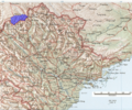
Biên giới Việt Trung
Chiến tranh Việt Nam
- Walter L. Hixson (1998). Military Aspects of the Vietnam Conflict. Taylor & Francis. ISBN 9780815335320.
- Xiaobing Li (2007). A History of the Modern Chinese Army. University Press of Kentucky. ISBN 9780813124384.
Tiếng Pháp
- Pierre Paul Famin (1895). Au Tonkin et sur la frontière du Kwang-si. A. Challamel, Original from Harvard University.
- P. Neis (1888). Sur les frontieres du Tonkin,. Bulletin de la Societe de Geographie de I'Est. 1.
Tiếng Anh
- Mayoury Ngaosrivathana and Kennon Breazeale (2002). Breaking new ground in Lao history. Chiang Mai [Thailand] : Silkworm Books. ISBN 9747551934.
- Søren Ivarsson (2008). Creating Laos: the making of a Lao space between Indochina and Siam, 1860-1945. Nordic Institute of Asian Studies. ISBN 9788776940232.
- Peter Zinoman (2001). The colonial Bastille: a history of imprisonment in Vietnam, 1862-1940. University of California Press. ISBN 0520224124.
- Choi Byung Wook (1 tháng 3 năm 2004). Southern Vietnam under the reign of Ming Mang. Cornell University Southeast Asia Program Publications. ISBN 0877271380.
- Human Rights Watch (tháng 10 năm 1991). Cambodia at war. Human Rights Watch. ISBN 1564321509.
Liên kết đến các trang Bản đồ& Hình ảnh
- The Vietnam Center and Archive
- Indochina and Thailand 1:250,000 topographic maps
- Indochina Atlas
- Topographic Maps of Vietnam
- Conquest of Tonkin
- France and Tongking : a narrative of the campaign of 1884 and the occupation of Further India
- Bản đồ tranh chấp biên giới Việt Nam Campuchia
- Great collection of books: South East Asia Vision
- topo maps of Indochina
- Border maps Cambodia-Thai-Vietnam
Thao khảo biên giới trên bộ
Bản đồ 9 gạch của Trung Quốc[1]
Biên Giới Việt Nam: vùng tiếp giáp tỉnh Quảng Tây Kỳ 1Kỳ 2Kỳ 3
Tổng Đèo Lương, thác Bản Giốc và núi Khấu Mai
1. Tổng Đèo Lương xưa thuộc tỉnh Cao Bằng, ở phía đông bắc tỉnh tỉnh này, phía nam là Thuỷ Khẩu, phía bắc có sông Quy Xuân chảy vào, diện tích khoảng 300km², mất vào tay TQ nhân dịp phân giới 1893-1894. Trên bản đồ hiện nay là phần lõm vào ở đông bắc Cao Bằng. Trường hợp mất được ghi vắn tắt qua nhật ký của Uỷ Ban Phân Giới vùng Quảng Tây, trong chiến dịch phân giới 1893-1894. Theo đó, phía TQ đã lấy tên của một số làng xã của phía TQ để đặt tên cho các làng xã thuộc tổng Đèo Lương. Song song đó, phía TQ vận động với Đặc Sứ Pháp tại Bắc Kinh để lấy vùng đất này, mặt khác, họ tìm cách kéo dài thì giờ, vì đây là điểm yếu của Pháp: càng kéo dài thì việc cắm mốc giới càng thêm tốn kém mà ngân sách của mẫu quốc dành cho Bắc Kỳ ngày thêm hạn chế. Cuối cùng, Pháp nhượng bộ trên vấn đề Ðèo-Lương nhưng với điều kiện phải được Pháp phải được trái núi quan trọng về chiến lược: Khấu Mai (TQ gọi là Khấu Mai Lĩnh, VN gọi là Cao May) ;
Như thế Việt Nam mất đất Đèo Lương vì lý do âm mưu đổi tên các làng mạc của TQ và sự nhượng bộ của Pháp. Ta thấy âm mưu hoán đổi tên các địa danh để chiếm lấy đất được sử dụng ở đây đã được sử dụng trước đó nhiều lần.
2. Thác Bản Giốc: Theo các chi tiết đã ghi trong các biên bản, nhật ký phân giới, sông Quy Xuân (Quy Thuận, Quây Sơn) chảy vào phía bắc của tổng Đèo Lương. Vào lúc phân giới thác Bản Giốc nằm sâu trong lãnh thổ của Việt Nam. Nếu không mất Đèo Lương thì sẽ không bao giờ có tranh chấp chủ quyền tại Bản Giốc vào những năm sau này, vì nó sẽ nằm sâu vào lãnh thổ VN.
Chương “Tình hình Trung Quốc lấn chiếm lãnh thổ Việt Nam từ năm 1954 đến nay” của sách Vấn đề biên giới giữa Việt Nam và Trung Quốc (Nxb. Sự Thật, năm 1979), Việt Nam tố cáo Trung Quốc chiếm thác Bản Giốc như sau:
“Năm 1955-1956, Việt Nam đã nhờ Trung Quốc in lại bản đồ nước Việt Nam tỉ-lệ 1/100.000. Lợi dụng lòng tin của Việt Nam, họ đã sửa ký hiệu một số đoạn đường biên giới dịch về phía Việt Nam, biến vùng đất của Việt Nam thành của Trung Quốc. Thí dụ: họ đã sửa ký hiệu ở khu vực thác Bản Giốc (mốc 53) thuộc tỉnh Cao Bằng, nơi họ định chiếm một phần thác Bản Giốc của Việt Nam và cồn Pò Thoong…
Tại khu vực cột mốc 53 (xã Ðàm Thuỷ, huyện Trùng Khánh, tỉnh Cao Bằng) trên sông Quy Thuận có thác Bản Giốc, từ lâu là của Việt Nam và chính quyền Bắc Kinh cũng đã công nhận sự thật đó. Ngày 29 tháng 2 năm 1976, phía Trung-Quốc đã huy động trên 2.000 người kể cả lực lượng vũ trang lập thành hàng rào bố phòng dày dặc bao quanh toàn bộ khu vực thác Bản Giốc thuộc lãnh thổ Việt Nam, cho công nhân cấp tốc xây dựng một đập kiên cố bằng bê tông cốt sắt ngang qua nhánh sông biên giới, làm việc đã rồi, xâm phạm lãnh-thổ Việt-Nam trên cồn Pò Thoong và ngang-nhiên nhận cồn này là của Trung-Quốc”.
3. Núi Khấu Mai: Núi này hoàn toàn thuộc Việt Nam theo biên giới lịch sử. Trong dịp phân giới và cắm mốc lại, núi này được trao đổi với tổng Đèo Lương: VN giữ núi Khấu Mai, TQ được tổng Đèo Lương. Nhưng phía TQ vẫn ngang ngược nhứt định dành nó về phía họ. Núi này khoảng giữa Bình Nhi và Thuỷ Khẩu, được cắm mốc mang số 15 trên biên bản phân giới ngày 19 tháng 6 năm 1894 ký kết giữa ông Galliéni và ông Thái Hy Bân. Núi này có vị trí chiến lược quan trọng, địa hình thuận tiện cho quân đội đóng quân, có đường mòn từ phía Việt Nam dẫn lên đỉnh. Trên núi có 3 nguồn nước, đất tốt nên dân chúng khai thác trồng trọt, cây cối xinh tươi. Chiếm giữ được nó thì có thể kiểm soát được cả vùng Long Châu cho tới Bằng Tường.
Do phía TQ trì trệ, không cắm mốc, rốt cục phía Pháp lại nhưọng bộ. Cột mốc tại Khấu Mai cắm trên sườn núi phía đông, cách đỉnh 200m, chừa một góc nhỏ cho TQ. Ngoài ra, cột mốc 14 cắm dưới chân phía Ðông, cột 16 dưới chân phía Tây-Bắc để xác định rõ ràng chủ quyền hai bên về ngọn núi.
Nhưng TQ lại không tôn trọng, xâm chiếm đất vùng này sau khi cắm mốc. Năm 1936, cột mốc số 14 bis được cắm thêm. Theo biên bản vị trí cột 14 bis xác định như sau: 580 mètres Sud-ouest de la borne 14 ; Est, Sud-Est de la borne 15. Cột 14 bis cách cột 14 là 580m về phía Tây-Nam; cột ở phía Ðông Ðông-Nam cột số 15.
Thư viện bản đồ

 Cửa sông Bắc Luân
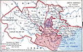 Biên giới Bắc kỳ, theo Pierre Paul Famin
- Mặt trận Vị Xuyên, Hà Giang 1984-1986
 Trung Quốc xâm lấn tại Bình Liêu, 1997
 Cột mốc biên giới Việt Nam - Trung Quốc theo Hiệp ước 1887
 Bản đồ tranh chấp biên giới Việt Nam - Campuchia năm 1976
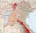 Bắc kỳ và vùng phụ thuộc (tô đỏ) 1893
 Đông Dương 1885
 Lãnh thổ bảo hộ Chân Lạp thời các Chúa Nguyễn
 Căn cứ - trại tị nạn các lực lượng kháng chiến Campuchia
 Căn cứ - trại tị nạn các lực lượng kháng chiến Campuchia từ sau 1985
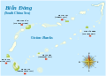 Bãi Union Banks, nơi xảy ra trận hải chiến Trường Sa 1988


Thư viện hình ảnh
 Ải Nam Quan khoảng những năm 1880
 Quân Pháp hạ thành Hà Nội, 1973
 Quân Pháp hạ thành Ninh Bình, 1973
 Quân Pháp hạ thành Nam Định, 1973
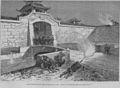 Quân Pháp hạ thành Hải Dương, 1973
 Thành lập lính tập bản xứ, khoảng 1973
 Diễu hành có voi tại Huế
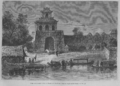 Cổng vào thành Huế
- Công chúa nhà NguyễnCông chúa nhà Nguyễn


Chiến tranh biên giới Việt Trung
Địa hình
The battlefield: geography and topographyThe geography of northern Vietnam played a crucial role in the 1979 campaign.Vietnamese geographer Le Ba Thao divides the northern, or Bac Bo, region intotwo distinct geographical entities, the northwest and the northeast, based on their geological age, the nature of their topography, and the density and type of flora.10 Thao postulates a dividing line between these areas that runs along the course of the Red River. The area to the south and west of the river, comprising the border provinces of Lai Chau and Hoang Lien Son, is mountainous and densely forested.
Vietnam’s highest mountain, Phan Xi Pang (3,143 meters), is in this area, andtravel here generally is difficult due to the elevation of the land and the steepness of the slopes. To the north and east of the Red River, in 1979 the border region comprised of a few administrative districts of Hoang Lien Son province and the provinces of Ha Tuyen, Cao Bang, Lang Son, and Quang Ninh, on the Gulf of Tonkin (VN: Vinh Bac Bo; CH: Beibu Wan). The northeastern region is a land of low hills and mountains. While less heavily forested than the northwest, it again is difficult for travel because of the numerous limestone formations (karst) that characterize the topography and shape the use of the land (Maps 1–4).11
The PAVN organized its military commands in the two northern provinces tofit these geographical realities. Its regional demarcation put the border provinces of Lang Son and Cao Bang in Military Region One and Ha Tuyen, Hoang Lien Son, and Lai Chau in Military Region Two. Quang Ninh province was designated a separate, special region for reasons of defense.12 Vietnam has never explained the reasoning behind this demarcation, but the most likely rationale for the structuring of the two military regions rests in the differing challenges they would present should their commanders be called upon to defend Hanoi against attack from the north. The sparse vegetation and low hills of Military Region One would enable forces to be moved and massed with relative ease – certainly when compared with the harsh topography and dense forestation of Military Region Two. Critical also, in defensive terms, is the short distance from the border to Hanoi: Lang Son, the key city of Military Region One, is 154 kilometers from the capital and Cao Bang 276 kilometers. The main city of Military Region Two, Lao Cai, is 295 kilometers from Hanoi. While charged to defend a more shallow front, however, the commander of Military Region One would be aided in this defense by the geography of the region and its man-made infrastructure.
Highway 1A from Lang Son and Highway 3 from Cao Bang cross the Cau River, a natural defensive line for Hanoi, and connect at Yen Vien before crossing the Red River and entering Hanoi, effectively channeling any invader toward a single point of attack against the city. In contrast, the roads from thetwo principal northwestern cities are confined by the mountains into separateand distant river valleys, obliging Military Region Two to defend against thepotential of a two-pronged assault against Hanoi.13
Geography also informed China’s invasion planning. The Chinese borderprovinces, Yunnan in the west and the Guangxi Zhuang Autonomous Region inthe east, are geographically dissimilar. Yunnan lies on the high, mountainousYun-Guei Plateau, remote and hard to access from China’s heartland, whileGuangxi is an area of low mountains and river plains affording greater ease oftroop movement. In the same way that Vietnam recognized the military implicationsof the geography of its border regions, China assigned its forces in its correspondingborder areas to two different commands, the Yunnan MilitaryDistrict going to the Kunming Military Region and Guangxi Military District tothe Guangzhou Military Region. The provincial and military district boundaryline ran from approximately where the Ha Tuyen and Cao Bang provinces meton the Vietnamese side of the border.14 The differing terrain of the two regionssignificantly also shaped the railroad and road networks. The railroad, whichwas vital for keeping the Chinese invasion forces supplied, had a short, straightrun from the eastern part of China, where most of the invasion force was based.By comparison, the railroad from China’s heartland to Kunming and fromKunming to Lao Cai took a long, circuitous route through steep hills and narrowvalleys. The highways to Kunming were similarly confined.
China chose to make its strongest attacks in 1979 against the cities of VietnameseMilitary Region One: Cao Bang and Lang Son. A major assault furtherto the west was deemed too perilous, because the long, narrow river valleys ofthe region presented an obstacle to the resupply of attacking forces and to thedifficulties that attack units would face in supporting one another. Attackingthrough Military Region One, in contrast, China could threaten Hanoi by a relativelyshort route, and the low hills and less dense vegetation would permit theeasier movement of troops and supplies back and forth. Of course, this was not anew plan of attack. In 1077, 1288, and 1427, Chinese forces had attackedthrough the same area. On each occasion, they had come to grief (Map 5).15
Quan hệ Việt Nam - Khmer Đỏ
What is certain is that the nationalisation of Cambodian communism led to violent incidents between the two sides long before the war against the Americans had finished. Between 1970 and 1975, according to internal Vietnamese figures, the Khmer Rouge provoked 174 armed military incidents that cost the lives of 600 cadres and soldiers. While this was a small fraction in terms of the total number of Vietnamese lost in Cambodia during the American war, 250,000, it meant that Indochineseinternationalism and Vietnamese–Cambodian collaboration were in trouble.32 From 1972, Khmer troops robbed Vietnamese munitions depots and attacked Vietnamese troops and cadres on mission. The Khmer Rouge, according to the Vietnamese, organised anti-Vietnamese demonstrations designed to “drive out the Vietnamese soldiers from Cambodia”. The Vietnamese claim that from this point the CPK began spreading such virulent propaganda as the ancient claim that the Vietnamese used Cambodian heads to serve tea. Internal Khmer Rouge documents confirm that Pol Pot’s soldiers had begun attacking Vietnamese arms depots and engaged in violent incidents with Vietnamese Communist soldiers along the border, a precursor of things to come once both movements came to power.33 Another study claims that the CPK approved the “anti-Vietnamese idea” for the first time in a party resolution adopted by a meeting of the Permanent Central Committee in September 1970.34 The CPK began to spread anti-Vietnamese slogans among the population, announcing that the Vietnamese “were uninvited guests” and that they “wanted to grab” Khmer lands.35 The resurgence of the anti-Vietnamese brand of Khmer nationalism in the CPK reinforced the breakdown of “internationalist” relations between these two parties from 1970.[1]
The Khmer Rouge was most hostile to the returning Vietnamese-trained Khmers, convinced that the Vietnamese would use them to reassert the Indochinese model and thereby sideline or control the CPK. After the Geneva Accords of 1954, 189 Khmer revolutionaries had been relocated to the North and another 322 joined them in the following years. They studied and worked in Vietnamese bases and schools. Some were incorporated into the VWP and others were placed in Khmer Party cells in northern Vietnam. Twenty-three of them studied in China for four to six years. They were indeed the Cambodian segment of the Indochinese revolution, trained much as the Lao had been in Vietnamese military and party schools. After the coup d’état of 1970, of the 520 Khmer Communist members in northern Vietnam, all but fifty-seven returned to Cambodia after March 1970. However, most of them were assassinated by the Khmer Rouge before 1975.36
Behind the smiling faces of the Khmer Rouge and their assurances of internationalist solidarity, things were bad on the ground. And COSVN must have known it. In late 1970, according to Vietnamese documents, Pol Pot met with members of the Central Committee of COSVN. According to the Vietnamese, he did his best to find faults in Vietnamese cadres and soldiers working in Cambodia and for his revolution. His main critique concerned the organisation of the General Staff in Cambodia. When he returned to Cambodia, he dissolved military and political organisms the Vietnamese had put in place and asked the Vietnamese to turn over all organisations in which Khmer were involved. It should be recalled that the Vietnamese advisory groups in Laos since the late 1950s had concentrated on military questions, building up the Pathet Lao party, administration, army and general staff in particular. It is hard to imagine Kaysone dissolving the VWP’s Group 100 or 959 in eastern Laos.37[2]
Chú thích
<references>
- The Third Indochina War: Conflict between China, Vietnam and Cambodia, 1972-79
Cass Series--Cold War History