Ancient and Primeval Beech Forests of the Carpathians and Other Regions of Europe is a transnational serial nature UNESCO World Heritage Site, encompassing 93 component parts (forests of European beech, Fagus sylvatica) in 18 European countries.[1][2][3] Together, the sites protect the largest and least disturbed forests dominated by the beech tree. In many of these stands (especially those in the Carpathians), these forests here were allowed to proceed without interruption or interference since the last ice age. These sites document the undisturbed postglacial repopulation of the species.[1]
| UNESCO World Heritage Site | |
|---|---|
_valley_42.jpg) Beușnița Waterfall in Nera Gorge-Beușnița National Park | |
| Location | (see map) |
| Reference | 1133quater |
| Inscription | 2007 (31st Session) |
| Extensions | 2011, 2017, 2021, 2023 |
Carpathian region
The Primeval Beech Forests of the Carpathians include ten separate massifs located along the 185 km (115 mi) long axis from the Rakhiv mountains and Chornohora ridge in Ukraine over the Poloniny Ridge (Slovakia) to the Vihorlat Mountains in Slovakia. The Ancient Beech Forests of Germany include five locations, cover 4,391 hectares and were added in 2011.
The Carpathian site covers a total area of 77,971.6 ha (192,672 acres), out of which only 29,278.9 ha (72,350 acres) are part of the actual preserved area, while the rest is considered a "buffer zone". Primeval Beech Forests of the Carpathians cover areas of Zakarpattia and Prešov Regions. Over 70% of the site is located in Ukraine. The area includes two national parks, and some habitat controlled areas, mostly in Slovakia. Both national parks, along with a neighboring area in Poland, compose a separate biosphere reserve, the East Carpathian Biosphere Reserve. Besides Havešová, Rožok, and Stužica (all of them located in Bukovské vrchy), there is a fourth component situated in Slovakia, named Kyjovský prales of Vihorlat. Ukrainian locations include Chornohora, Kuziy-Trybushany, Maramarosh,[n 1] Stuzhytsia–Uzhok, Svydovets, and Uholka–Shyrikyi Luh. Only a few of the ten components are accessible to visitors. Stužica is the only one of three locations in Bukovské vrchy (Slovakia) with available hiking trails. In 2017, UNESCO extended the site, adding forests in Albania, Austria, Belgium, Bulgaria, Croatia, Italy, Romania, Slovenia, and Spain.[4] In 2021 UNESCO extended the site again adding forests in Bosnia and Herzegovina, Czechia, France, Italy, North Macedonia, Poland, Slovakia and Switzerland.[5]
The last intact virgin forest in the temperate latitudes of Europe is to be found in the Carpathians. Trees can live to a hundred years old in these forests, providing an important habitat for organisms such as mushrooms, moss, lichen, insects, rare birds (e.g. capercaillie and black grouse) and mammals (e.g. bats, brown bear, wolf and lynx). Large parts of the forest in the Romanian part of the Carpathians have been lost due to deforestation. The pressure on timber as a resource may increase due to international demand and European companies may start large-scale felling in neighbouring Ukraine. Currently unprotected areas of virgin forest can be permanently preserved in the Ukrainian Carpathians by expanding and reinforcing conservation areas. In the Ukrainian Carpathians there are nine national parks and two biosphere reserves. There is a general ban on tree felling in coniferous forest areas above 1,100 metres. If park administrations are shown to work, management of larger, previously unprotected areas of virgin forest to preserve them on a permanent basis, may occur. There are roughly 100,000 additional hectares of forest which could be integrated into the existing conservation areas.[6]
List of component parts


The component parts included in the site as of December 2023 are:[1][7][8][9][10][11][12][13][14][2][3][15]
| Country | Serial ID No. or ID | Component part | Component cluster | Property [ha] | Buffer zone [ha] | Year inscrib. | Centre point coordinates |
|---|---|---|---|---|---|---|---|
| Carpathian Beech Forest Region | |||||||
| Ukraine | 1133quinquies-001 UA_CBR | Chornohora | 2,476.80 | 12,925.00 | 2007 | 48°8′25″N 24°23′35″E / 48.14028°N 24.39306°E | |
| 1133quinquies-002 UA_CBR | Kuziy-Trybushany | 1,369.60 | 3,163.40 | 2007 | 47°56′21″N 24°8′26″E / 47.93917°N 24.14056°E | ||
| 1133quinquies-003 UA_CBR | Maramarosh[n 1] | 2,243.60 | 6,230.40 | 2007 | 47°56′12″N 24°19′35″E / 47.93667°N 24.32639°E | ||
| 1133quinquies-004 UA_UNNP | Stuzhytsia-Uzhok | 2,532.00 | 3,615.00 | 2007 | 49°4′58″N 22°35′45″E / 49.08278°N 22.59583°E[n 2] | ||
| 1133quinquies-005 UA_CBR | Svydovets | 3,030.50 | 5,639.50 | 2007 | 48°11′21″N 24°13′37″E / 48.18917°N 24.22694°E | ||
| 1133quinquies-006 UA_CBR | Uholka-Shyrokyi Luh[n 3] | 11,860.00 | 3,301.00 | 2007 | 48°18′22″N 23°41′46″E / 48.30611°N 23.69611°E | ||
| 1133quinquies-063 UA_GORG | Gorgany | 753.48 | 4,637.59 | 2017 | 48°28′19″N 24°17′58″E / 48.47194°N 24.29944°E | ||
| 1133quinquies-066 UA_SYNE | Darvaika | Synevyr | 1,588.46 | 312.32 | 2017 | 48°29′14″N 23°44′56″E / 48.48722°N 23.74889°E | |
| 1133quinquies-067 UA_SYNE | Kvasovets | 561.62 | 333.63 | 2017 | 48°23′6″N 23°42′46″E / 48.38500°N 23.71278°E | ||
| 1133quinquies-068 UA_SYNE | Strymba | 260.65 | 191.14 | 2017 | 48°27′11″N 23°47′48″E / 48.45306°N 23.79667°E | ||
| 1133quinquies-069 UA_SYNE | Vilshany | 454.31 | 253.85 | 2017 | 48°21′20″N 23°39′36″E / 48.35556°N 23.66000°E | ||
| 1133quinquies-070 UA_ZACH | Irshavka | Zacharovanyi Krai | 93.97 | 1,275.44 | 2017 | 48°27′9″N 23°5′23″E / 48.45250°N 23.08972°E | |
| 1133quinquies-071 UA_ZACH | Velykyi Dil | 1,164.16 | 2017 | 48°25′21″N 23°9′42″E / 48.42250°N 23.16167°E | |||
| Slovakia | 1133quinquies-089 SK-POLO-01 | Havešová | Poloniny | 167.88 | 6,474.84 | 2007 2021* | 49°0′35″N 22°20′14″E / 49.00972°N 22.33722°E |
| 1133quinquies-090 SK-POLO-02 | Rožok | 74.37 | 1,138.89 | 2007 2021* | 48°58′40″N 22°27′52″E / 48.97778°N 22.46444°E | ||
| 1133quinquies-091 SK-POLO-03 | Stužica – Bukovské Vrchy | 1,742.47 | 5,694.84 | 2007 2021* | 49°5′3″N 22°29′42″E / 49.08417°N 22.49500°E | ||
| 1133quinquies-092 SK-POLO-04 | Udava | 455.82 | 814.69 | 2007 2021* | 49°10′31″N 22°13′39″E / 49.17528°N 22.22750°E | ||
| 1133quinquies-093 SK-VIHO-02 | Vihorlat | 1,553.06 | 854.08 | 2007 2021* | 48°54′56″N 22°11′13″E / 48.91556°N 22.18694°E | ||
| Romania | 1133quinquies-043 RO_NERE | Cheile Nerei-Beușnița | 4,292.27 | 5,959.87 | 2017 | 44°54′19″N 21°48′40″E / 44.90528°N 21.81111°E | |
| 1133quinquies-044 RO_SINC | Sinca secular forest (Codrul secular Șinca) | 338.24 | 445.76 | 2017 | 45°40′0″N 25°10′14″E / 45.66667°N 25.17056°E | ||
| 1133quinquies-045 RO_SLAT | Slătioara secular forest (Codrul secular Slătioara) | 609.12 | 429.43 | 2017 | 47°26′36″N 25°37′39″E / 47.44333°N 25.62750°E | ||
| 1133quinquies-046 RO_COZI | Cozia Massif | Cozia | 2,285.86 | 2,408.83 | 2017 | 45°19′54″N 24°19′32″E / 45.33167°N 24.32556°E | |
| 1133quinquies-047 RO_COZI | Lotrisor | 1,103.30 | 2017 | 45°17′43″N 24°15′33″E / 45.29528°N 24.25917°E | |||
| 1133quinquies-048 RO_DOMO | Domogled-Coronini-Bedina | Domogled – Valea Cernei | 5,110.63 | 51,461.28 | 2017 | 44°56′31″N 22°28′7″E / 44.94194°N 22.46861°E | |
| 1133quinquies-049 RO_DOMO | Iauna Craiovei | 3,517.36 | 2017 | 45°6′31″N 22°34′41″E / 45.10861°N 22.57806°E | |||
| 1133quinquies-050 RO_DOMO | Ciucevele Cernei | 1,104.27 | 2017 | 45°14′40″N 22°49′23″E / 45.24444°N 22.82306°E | |||
| 1133quinquies-051 RO_TIBL | Izvorul Șurii | Groșii Țibleșului | 210.55 | 563.57 | 2017 | 47°32′59″N 24°11′9″E / 47.54972°N 24.18583°E | |
| 1133quinquies-052 RO_TIBL | Preluci | 135.82 | 2017 | 47°32′5″N 24°13′13″E / 47.53472°N 24.22028°E | |||
| 1133quinquies-053 RO_IZVO | Izvoarele Nerei | 4,677.21 | 2,494.83 | 2017 | 45°7′21″N 22°3′59″E / 45.12250°N 22.06639°E | ||
| 1133ter-046 RO_STRA | Strâmbu Băiuț[n 4] | 598.14 | 713.09 | 2017 | 47°37′33″N 24°4′23″E / 47.62583°N 24.07306°E | ||
| Poland | 1133quinquies-085 PL-BIES-01 | Border Ridge and Górna Solinka valley[n 5] | Bieszczady | 1,506.05 | 24,330.52 | 2021 | 49°5′58″N 22°33′24″E / 49.09944°N 22.55667°E |
| 1133quinquies-086 PL-BIES-02 | Połonina Wetlińska and Smerek[n 6] | 1,178.03 | 2021 | 49°10′51″N 22°30′12″E / 49.18083°N 22.50333°E | |||
| 1133quinquies-087 PL-BIES-03 | Terebowiec stream valley | 201.00 | 2021 | 49°5′37″N 22°43′29″E / 49.09361°N 22.72472°E | |||
| 1133quinquies-088 PL-BIES-04 | Wołosatka stream valley | 586.66 | 2021 | 49°4′1″N 22°44′41″E / 49.06694°N 22.74472°E | |||
| Polonic-Podoloc-Moldovan Beech Forest Region | |||||||
| Ukraine | 1133quinquies-064 UA_ROZT | Roztochchia[n 7] | 384.81 | 598.21 | 2017 | 49°57′44″N 23°38′58″E / 49.96222°N 23.64944°E | |
| 1133quinquies-065 UA_SATA | Satanіvska Dacha | 212.01 | 559.37 | 2017 | 49°10′26″N 26°14′56″E / 49.17389°N 26.24889°E | ||
| Baltic Beech Forest Region | |||||||
| Germany | 1133quinquies-007 DE_JASM | Jasmund | 492.50 | 2,510.50 | 2011 | 54°32′53″N 13°38′43″E / 54.54806°N 13.64528°E | |
| 1133quinquies-008 DE_SERR | Serrahn | 268.10 | 2,568.00 | 2011 | 53°20′24″N 13°11′52″E / 53.34000°N 13.19778°E | ||
| 1133quinquies-009 DE_GRUM | Grumsin | 590.10 | 274.30 | 2011 | 52°59′11″N 13°53′44″E / 52.98639°N 13.89556°E | ||
| Subatlantic-Hercynic Beech Forest Region | |||||||
| Germany | 1133quinquies-010 DE_HAIN | Hainich | 1,573.40 | 4,085.40 | 2011 | 51°04′43″N 10°26′08″E / 51.07861°N 10.43556°E | |
| 1133quinquies-011 DE_KELL | Kellerwald | 1,467.10 | 4,271.40 | 2011 | 51°08′43″N 8°58′25″E / 51.14528°N 8.97361°E | ||
| Czech Republic | 1133quinquies-075 CZ-JIZE-01 | Jizera Mountains | 444.81 | 2,279.40 | 2021 | 50°51′30″N 15°9′20″E / 50.85833°N 15.15556°E | |
| France | 1133quinquies-077 FR-GRAN-01 | Grand Ventron | 319.00 | 1,328.00 | 2021 | 47°58′20″N 6°56′23″E / 47.97222°N 6.93972°E | |
| Switzerland | 1133quinquies-073 CH-BETT-01 | Bettlachstock Forest (Forêt de la Bettlachstock) | 195.43 | 1,094.16 | 2021 | 47°13′22″N 7°24′43″E / 47.22278°N 7.41194°E | |
| Alpic Beech Forest Region | |||||||
| Austria | 1133quinquies-014 AT_DUER | Dürrenstein-Lassingtal | 3,685.27 | 3,089.78 | 2017 2023* | 47°46′12″N 15°2′51″E / 47.77000°N 15.04750°E | |
| 1133quinquies-015 AT_KALK | Hintergebirge | Kalkalpen | 2,946.20 | 14,197.24 | 2017 | 47°44′58″N 14°28′56″E / 47.74944°N 14.48222°E | |
| 1133quinquies-016 AT_KALK | Bodinggraben | 890.89 | 2017 | 47°47′14″N 14°21′12″E / 47.78722°N 14.35333°E | |||
| 1133quinquies-017 AT_KALK | Urlach | 264.82 | 2017 | 47°48′15″N 14°14′22″E / 47.80417°N 14.23944°E | |||
| 1133quinquies-018 AT_KALK | Wilder Graben | 1,149.75 | 2017 | 47°50′00″N 14°26′1″E / 47.83333°N 14.43361°E | |||
| Switzerland | 1133quinquies-074 CH-LODA-01 | Forest reserves of Lodano, Busai and Soladino Valleys | 806.78 | 2,330.74 | 2021 | 46°15′49″N 8°39′11″E / 46.26361°N 8.65306°E | |
| France | 1133quinquies-076 FR-CHAP-01 | Chapitre | 371.30 | 41.65 | 2021 | 44°38′4″N 5°59′55″E / 44.63444°N 5.99861°E | |
| Atlantic Beech Forest Region | |||||||
| Belgium | 1133quinquies-019 BE_SONI | Forest Reserve “Joseph Zwaenepoel” | Sonian Forest (Forêt de Soignes) | 187.34 | 4,650.86 | 2017 | 50°45′23″N 4°25′00″E / 50.75639°N 4.41667°E |
| 1133quinquies-020 BE_SONI | Grippensdelle A | 24.11 | 2017 | 50°46′54″N 4°25′36″E / 50.78167°N 4.42667°E | |||
| 1133quinquies-021 BE_SONI | Grippensdelle B | 37.38 | 2017 | 50°47′1″N 4°25′57″E / 50.78361°N 4.43250°E | |||
| 1133quinquies-022 BE_SONI | Réserve forestière du Ticton A | 13.98 | 2017 | 50°44′3″N 4°26′13″E / 50.73417°N 4.43694°E | |||
| 1133quinquies-023 BE_SONI | Réserve forestière du Ticton B | 6.50 | 2017 | 50°43′37″N 4°25′51″E / 50.72694°N 4.43083°E | |||
| Moesian-Balcanic Beech Forest Region | |||||||
| Albania | 1133quinquies-012 AL_LUMI | Lumi i gashit | 1,261.52 | 8,977.48 | 2017 | 42°25′36″N 20°05′45″E / 42.42667°N 20.09583°E | |
| 1133quinquies-013 AL_RRAJ | Rrajca | 2,129.45 | 2,569.75 | 2017 | 41°12′11″N 20°30′2″E / 41.20306°N 20.50056°E | ||
| North Macedonia | 1133quinquies-084 MN-DLAB-01 | Dlaboka Reka | 193.27 | 234.70 | 2021 | 41°45′47″N 20°35′16″E / 41.76306°N 20.58778°E | |
| Bulgaria | 1133quinquies-024 BG_BALK | Boatin Reserve | Central Balkan | 1,226.88 | 851.22 | 2017 | 42°48′10″N 24°16′9″E / 42.80278°N 24.26917°E |
| 1133quinquies-025 BG_BALK | Tsarichina Reserve | 1,485.81 | 1,945.99 | 2017 | 42°46′32″N 24°24′18″E / 42.77556°N 24.40500°E | ||
| 1133quinquies-026 BG_BALK | Kozya stena Reserve | 644,43 | 289.82 | 2017 | 42°47′47″N 24°31′2″E / 42.79639°N 24.51722°E | ||
| 1133quinquies-027 BG_BALK | Steneto Reserve[n 8] | 2,466.10 | 1,762.01 | 2017 | 42°44′43″N 24°42′26″E / 42.74528°N 24.70722°E | ||
| 1133quinquies-028 BG_BALK | Stara Reka Reserve[n 9] | 591.20 | 1,480.04 | 2017 | 42°42′11″N 24°49′8″E / 42.70306°N 24.81889°E | ||
| 1133quinquies-029 BG_BALK | Dzhendema Reserve | 1,774.12 | 2,576.63 | 2017 | 42°41′44″N 24°58′23″E / 42.69556°N 24.97306°E | ||
| 1133quinquies-030 BG_BALK | Severen Dzhendem Reserve | 926.37 | 1,066.47 | 2017 | 42°44′44″N 24°56′5″E / 42.74556°N 24.93472°E | ||
| 1133quinquies-031 BG_BALK | Peeshti skali Reserve[n 10] | 1,049.10 | 968.14 | 2017 | 42°45′54″N 25°4′29″E / 42.76500°N 25.07472°E | ||
| 1133quinquies-032 BG_BALK | Sokolna Reserve | 824.90 | 780.55 | 2017 | 42°41′52″N 25°8′18″E / 42.69778°N 25.13833°E | ||
| Illyric Beech Forest Region | |||||||
| Croatia | 1133quinquies-033 HR_HAJD | Forest reserves Hajdučki i Rožanski kukovi | 1,289.11 | 9,869.25 | 2017 | 44°45′59″N 15°0′39″E / 44.76639°N 15.01083°E | |
| 1133quinquies-034 HR_PAKL-01 | Paklenica National Park (formerly PNP - Suva draga-Klimenta and PNP - Oglavinovac-Javornik) | 2,036.81 | 824.86 | 2017 2023* | 44°20′26″N 15°30′1″E / 44.34056°N 15.50028°E | ||
| Slovenia | 1133quinquies-055 SI_KROK | Krokar | 74.50 | 47.90 | 2017 | 45°32′31″N 14°46′8″E / 45.54194°N 14.76889°E | |
| 1133quinquies-056 SI_SNEZ | Snežnik-Ždrocle | 720.24 | 128.80 | 2017 | 45°35′5″N 14°27′19″E / 45.58472°N 14.45528°E | ||
| Bosnia and Herzegovina | 1133quinquies-072 BH-JANJ-01 | Prašuma Janj | 295.04 | 380.74 | 2021 | 44°8′48″N 17°16′52″E / 44.14667°N 17.28111°E | |
| Central Mediterranean Beech Forest Region | |||||||
| Italy | 1133quinquies-035 IT_ABRU | Cervara Valley (Valle Cervara) | Abruzzo, Lazio & Molise | 119.70 | 751.61 | 2017 | 41°49′56″N 13°43′43″E / 41.83222°N 13.72861°E |
| 1133quinquies-036 IT_ABRU | Selva Moricento | 192.70 | 2017 | 41°50′49″N 13°42′20″E / 41.84694°N 13.70556°E | |||
| 1133quinquies-037 IT_ABRU | Coppo del Morto | 104.71 | 415.51 | 2017 | 41°51′37″N 13°50′48″E / 41.86028°N 13.84667°E | ||
| 1133quinquies-038 IT_ABRU | Coppo del Principe | 194.49 | 446.62 | 2017 | 41°47′15″N 13°44′39″E / 41.78750°N 13.74417°E | ||
| 1133quinquies-039 IT_ABRU | Fondillo Valley (Val Fondillo) | 325.03 | 700.95 | 2017 | 41°45′15″N 13°53′9″E / 41.75417°N 13.88583°E | ||
| 1133quinquies-081 IT-POLL-01 | Cozzo Ferriero | Pollino National Park | 95.75 | 2,851.83 | 2017 2021* | 39°54′19″N 16°6′4″E / 39.90528°N 16.10111°E | |
| 1133quinquies-082 IT-POLL-02 | Pollinello | 477.94 | 2021 | 39°53′43″N 16°11′54″E / 39.89528°N 16.19833°E | |||
| 1133quinquies-083 IT-VALL-01 | Infernale Valley (Valle Infernale) | 320.79 | 2,191.36 | 2021 | 38°7′55″N 15°57′41″E / 38.13194°N 15.96139°E | ||
| 1133quinquies-079 IT-FUMB-01 | Falascone | Umbra Forest (Foresta Umbra) | 254.30 | 3,486.29 | 2017 2021* | 41°48′21″N 15°58′41″E / 41.80583°N 15.97806°E | |
| 1133quinquies-080 IT-FUMB-02 | Pavari-Sfilzi | 667.13 | 2021 | 41°50′20″N 16°1′25″E / 41.83889°N 16.02361°E | |||
| 1133quinquies-040 IT_CIMI | Monte Cimino | 57.54 | 87.96 | 2017 | 42°24′31″N 12°12′11″E / 42.40861°N 12.20306°E | ||
| 1133quinquies-041 IT_RASC | Monte Raschio | 73.73 | 54.75 | 2017 | 42°10′25″N 12°9′40″E / 42.17361°N 12.16111°E | ||
| 1133quinquies-042 IT_SASS | Sasso Fratino | 781.43 | 6,936.64 | 2017 | 43°50′40″N 11°48′11″E / 43.84444°N 11.80306°E | ||
| Pyrenaic-Iberian Beech Forest Region | |||||||
| Spain | 1133quinquies-057 ES_AYLL | Tejera Negra | Beech forests of Ayllón (Hayedos de Ayllón) | 255.52 | 13,880.86 | 2017 | 41°14′43″N 3°23′19″W / 41.24528°N 3.38861°W[n 11] |
| 1133quinquies-058 ES_AYLL | Montejo | 71.79 | 2017 | 41°6′44″N 3°29′58″W / 41.11222°N 3.49944°W | |||
| 1133quinquies-059 ES_NAVA | Lizardoia | Beech forests of Navarra (Hayedos de Navarra) | 63.97 | 24,494.52 | 2017 | 43°0′23″N 1°6′46″W / 43.00639°N 1.11278°W | |
| 1133quinquies-060 ES_NAVA | Aztaparreta | 171.06 | 2017 | 42°54′39″N 0°48′58″W / 42.91083°N 0.81611°W | |||
| 1133quinquies-061 ES_PICO | Cuesta Fría[n 12] | Beech forests of Picos de Europa (Hayedos de Picos de Europa) | 213.65 | 14,253.00 | 2017 | 43°10′21″N 4°59′16″W / 43.17250°N 4.98778°W | |
| 1133quinquies-062 ES_PICO | Canal de Asotin | 109.58 | 2017 | 43°10′16″N 4°53′21″W / 43.17111°N 4.88917°W | |||
| France | 1133quinquies-078 FR-MASS-01 | Massane | 239.50 | 1,432.30 | 2021 | 42°28′58″N 3°1′45″E / 42.48278°N 3.02917°E | |
* Only boundary modification.
Udava (Bukovské Vrchy, Slovakia) was created by modifying the boundary of Stužica before. Falascone (Italy) in turn was named previously Umbra Forest (Foresta Umbra).[13][14][2]
This is a transnational serial nature UNESCO World Heritage Site, encompassing 94 component parts (forests) in 18 European countries.[1][2] The total area of component parts is 98,125.15 ha (242,472.5 acres), including buffer zones 392,846.02 ha (970,743.7 acres). The largest total area of component parts is in Ukraine and Romania – 54% total (41% including buffer zones).
Forms of protection
Component parts of this property overlap more or less with various protected areas like national parks, nature reserves, Natura 2000 network.[16][17][18][11][13][19][20]
Abbreviations:
C – count of component parts in a given cluster
N – overlapping with Natura 2000 areas
| Country | Component cluster | C | Protected area | N | Region |
|---|---|---|---|---|---|
| Albania | Lumi i Gashit | 1 | Strict nature reserve of Gashi River | Kukës | |
| Rrajca | 1 | Shebenik – Jabllanicë National Park | Elbasan | ||
| Austria | Dürrenstein-Lassingtal | 1 | Wilderness Area Dürrenstein | Yes | Lower Austria |
| Kalkalpen | 4 | Kalkalpen National Park | Yes | Upper Austria | |
| Belgium | Sonian Forest (Forêt de Soignes) | 5 | 3 strict forest reserves within Sonian Forest Protected Landscape – “Joseph Zwaenepoel”, Grippensdelle and Ticton | Yes | Flanders, Brussels Capital Region, Wallonia |
| Bosnia and Herzegovina | Prašuma Janj | 1 | Prašuma Janj strict nature reserve | Bosanska Krajina | |
| Bulgaria | Central Balkan | 9 | 9 strict reserves in the Central Balkan National Park – Boatin, Dzhendema, Kozya stena, Peeshti skali[n 10], Severen Dzhendem, Sokolna, Stara reka, Steneto and Tsarichina | Yes | Lovech, Plovdiv, Stara Zagora, Gabrovo (central Balkan Mountains) |
| Croatia | Hajdučki i Rožanski kukovi | 1 | Hajdučki and Rožanski Kukovi strict reserve within Northern Velebit National Park | Yes | Lika-Senj |
| Paklenica National Park | 2 | Paklenica National Park | Yes | Lika-Senj, Zadar (Dinaric region, or Dinaric Alps) | |
| Czech Republic | Jizera Mountains | 1 | Jizerskohorské bučiny National Nature Reserve | Yes | Liberec |
| France | Chapitre | 1 | Chapitre-Petit-Buëch biological strict reserve | Yes | Provence-Alpes-Côte d'Azur |
| Grand Ventron | 1 | Massif du Grand Ventron National Nature Reserve | Yes | Grand Est | |
| Massane | 1 | Massane National Nature Reserve | Yes | Occitanie | |
| Germany | Grumsin | 1 | Schorfheide-Chorin Biosphere Reserve | Yes | Brandenburg |
| Hainich | 1 | Hainich National Park | Yes | Thuringia | |
| Jasmund | 1 | Jasmund National Park | Yes | Mecklenburg-Vorpommern | |
| Kellerwald | 1 | Kellerwald-Edersee National Park | Yes | Hesse | |
| Serrahn | 1 | Müritz National Park | Yes | Mecklenburg-Vorpommern | |
| Italy | Abruzzo, Lazio & Molise | 5 | Abruzzo, Lazio and Molise National Park | Yes | Abruzzo |
| Umbra Forest (Foresta Umbra) | 2 | Strict reserves within Gargano National Park – Sfilzi, Falascone and Foresta Umbra | Yes | Apulia | |
| Monte Cimino | 1 | Regional Natural Monument and municipal strict reserve | Yes | Lazio | |
| Monte Raschio | 1 | Regional Natural Park Bracciano-Martignano | Yes | Lazio | |
| Pollino National Park | 2 | Cozzo Ferriero and Pollinello strict reserves within Pollino National Park | Yes | Calabria, Basilicata | |
| Sasso Fratino | 1 | Sasso Fratino strict reserve in Foreste Casentinesi, Monte Falterona, Campigna National Park | Yes | Emilia-Romagna, Tuscany | |
| Infernale Valley (Valle Infernale) | 1 | Valle Infernale strict reserve within Aspromonte National Park | Yes | South Calabria | |
| North Macedonia | Dlaboka Reka | 1 | Forest reserves within Mavrovo National Park | Mavrovo and Rostuša and Gostivar | |
| Poland | Bieszczady | 4 | Bieszczady National Park, East Carpathian Biosphere Reserve | Yes | Podkarpackie Voivodeship |
| Romania | Cheile Nerei-Beușnița | 1 | Strictly protected zone of the Cheile Nerei-Beușnița National Park | Yes | Caraș-Severin |
| Sinca secular forest (Codrul secular Șinca) | 1 | Strictly protected through the forest management plan | Yes | Brașov | |
| Slătioara secular forest (Codrul secular Slătioara) | 1 | Part of Codrul Secular Slătioara forest reserve, Secular Meadows Todirescu floristic reserve | Yes | Suceava | |
| Cozia | 2 | Cozia National Park | Yes | Vâlcea | |
| Domogled – Valea Cernei | 3 | Domogled-Valea Cernei National Park | Yes | Mehedinți, Caraș-Severin, Gorj | |
| Groșii Țibleșului | 2 | Strictly protected through the forest management plan | Yes | Maramureș | |
| Izvoarele Nerei | 1 | Izvoarele Nerei strict reserve within Semenic-Cheile Carașului National Park | Yes | Caraș-Severin | |
| Strâmbu Băiuț[n 4] | 1 | Strictly protected through the forest management plan | Yes | Maramureș | |
| Slovakia | Poloniny | 4 | National nature reserves Stužica, Jarabá skala, Pľaša and Borsukov vrch (Stužica – Bukovské Vrchy), Rožok, Havešová, nature reserve Udava within Poloniny National Park, East Carpathian Biosphere Reserve | Yes | Prešov |
| Vihorlat | 1 | Vihorlat national nature reserve within Vihorlat Protected Landscape Area | Yes | Prešov | |
| Slovenia | Krokar | 1 | Forest reserve Virgin forest Krokar | Yes | Kočevje |
| Snežnik–Ždrocle | 1 | Snežnik–Ždrocle forest reserve | Yes | Inner Carniola | |
| Spain | Beech forests of Ayllón (Hayedos de Ayllón) | 2 | Tejera Negra: Sierra Norte de Guadalajara Natural Park, Montejo: Sierra del Rincón Biosphere Reserve | Yes | Castilla-La Mancha |
| Beech forests of Navarra (Hayedos de Navarra) | 2 | Integral (strict) reserves of Lizardoia and Aztaparreta | Yes | Navarre | |
| Beech forests of Picos de Europa (Hayedos de Picos de Europa) | 2 | Picos de Europa National Park, Biosphere Reserve | Yes | Castile and León | |
| Switzerland | Bettlachstock Forest (Forêt de la Bettlachstock) | 1 | Forest reserve Bettlachstock–Hasenmatt | Canton of Solothurn | |
| Forest reserves of Lodano, Busai and Soladino Valleys | 1 | Lodano Valley forest reserve, Busai and Soladino Valleys forest reserve | Canton of Ticino | ||
| Ukraine | Chornohora | 1 | Carpathian Biosphere Reserve | Zakarpattia | |
| Kuziy – Trybushany | 1 | Carpathian Biosphere Reserve | Zakarpattia | ||
| Maramarosh | 1 | Carpathian Biosphere Reserve | Zakarpattia | ||
| Stuzhytsia – Uzhok | 1 | Uzh National Nature Park | Zakarpattia | ||
| Svydovets | 1 | Carpathian Biosphere Reserve | Zakarpattia | ||
| Uholka – Shyrokyi Luh[n 3] | 1 | Carpathian Biosphere Reserve | Zakarpattia | ||
| Synevyr | 4 | Synevyr National Nature Park | Zakarpattia | ||
| Zacharovanyi Krai | 2 | Zacharovanyi Krai National Nature Park | Zakarpattia | ||
| Gorgany | 1 | Gorgany Nature Reserve | Ivano-Frankivsk | ||
| Roztochchya[n 7] | 1 | Roztochchia Nature Reserve, Roztochchia Biosphere Reserve | Lviv | ||
| Satanіvska Dacha | 1 | Podilski Tovtry National Nature Park | Khmelnytskyi |
Tentative list
This forest is placed on the World Heritage Tentative list as a proposal for the expansion of the Ancient and Primeval Beech Forests of the Carpathians and Other Regions of Europe site:
Montenegro[21]
- Virgin Forest Reserve in NP Biogradska Gora
Serbia[12]
Gallery
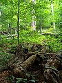 Forest in Stuzica
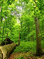 Havešová
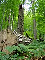 Stužica
 Freshwater stream in Stužica
 Stužica
 Dlaboka Reka


Notes
References
External links
- "Ancient and Primeval Beech Forests of the Carpathians and Other Regions of Europe". UNESCO World Heritage Centre. Retrieved 28 September 2008.