Jump to content

Wakayama Prefecture

135°10′3.0″E / 34.226028°N 135.167500°E / 34.226028; 135.167500
From Simple English Wikipedia, the free encyclopedia
Wakayama
和歌山県
Japanese transcription(s)
 • RomajiWakayama-ken
Flag of Wakayama
Official seal of Wakayama
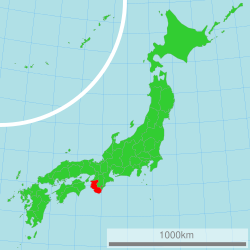
Location of Wakayama in Japan
Coordinates: 34°13′33.7″N 135°10′3.0″E / 34.226028°N 135.167500°E / 34.226028; 135.167500
Country Japan
RegionKansai
IslandHonshū
CapitalWakayama
Government
 • GovernorYoshinobu Nisaka
Area
 • Total4,725.67 km2 (1,824.59 sq mi)
 • Rank30th
Population
 (April 1, 2012)
 • Total989,983
 • Rank39th
 • Density210/km2 (540/sq mi)
ISO 3166 codeJP-30
Prefectural flowerUme blossom (Prunus mume)
Prefectural treeUbame oak (Quercus phillyraeoides)
Prefectural birdJapanese white-eye (Zosterops japonica)
Number of districts6
Number of municipalities30
Websitewww.wakayama.lg.jp/
english/

Wakayama Prefecture (和歌山県, Wakayama-ken) is a prefecture in the Kansai region of Japan on the island of Honshū.[1] The capital is the city of Wakayama.[2] Wakayama Prefecture is surrounded by Osaka Prefecture, Nara Prefecture, Mie Prefecture, Hyogo Prefecture and Tokushima Prefecture.

Historychange source

In the Meiji period, Wakayama Prefecture was created from the western part of Kii Province.[3]

Geographychange source

Wakayama's southwestern coastline faces the Seto Inland Sea and its southeastern coastline is on the Pacific Ocean. The northern borders of the prefecture meet Osaka Prefecture, Nara Prefecture, and Mie Prefecture.

Citieschange source

There are nine cities in Wakayama Prefecture:

Towns and villageschange source

These are the towns and villages in each district:

  • Arida District
    • Aridagawa
    • Hirogawa
    • Yuasa
  • Hidaka District
    • Hidaka
    • Inami
    • Hidakagawa
    • Mihama
    • Minabe
    • Yura
  • Higashimuro District
    • Kitayama
    • Kozagawa
    • Kushimoto
    • Nachikatsuura
    • Taiji
  • Ito District
    • Katsuragi
    • Kōya
    • Kudoyama
  • Kaisō District
    • Kimino
  • Nishimuro District

National Parkschange source

National Parks are established in about 9% of the total land area of the prefecture.[4]

Shrines and Templeschange source

Hinokuma-kunikakasu jinjū is the chief Shinto shrine (ichinomiya) in the prefecture.[5]

Related pageschange source

Referenceschange source

Other websiteschange source

Media related to Wakayama prefecture at Wikimedia Commons


🔥 Top keywords: Main PageSpecial:Search0Slash (punctuation)BlackSpecial:RecentChanges4 (number)DavidSOLID (object-oriented design)Wikipedia:AboutFile:Sexual intercourse with internal ejaculation.webmHelp:ContentsHelp:IntroductionLisa Sparxxx2023 UEFA Champions League FinalColour24-hour clockAdolf Hitler UunonaBismillahir Rahmanir Raheem6 (number)T. N. SeshanFile:ASCII-Table-wide.svg20 (number)Poor Things (movie)United StatesCristiano RonaldoList of people who have walked on the MoonAli Malikov50 (number)17 (number)The Valley (2024 TV series)GrassList of mathematical symbolsList of U.S. states and territories by time zone8 (number)List of countries by areaWikipedia:Simple talkList of largest Hindu templesRama