Okinawa Prefecture
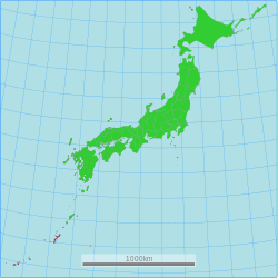
Okinawa Prefecture (沖縄県, Japanese: Okinawa-ken, Okinawan: Uchinaa-chin[1]) is traditionally a prefecture in the Kyūshū region of Japan.[2] Okinawa Prefecture is made up of islands which are southwest of the island of Kyushu.[3] Recent government proposals recognize the prefecture as its own region.[4]
Okinawa Prefecture 沖縄県 | |
|---|---|
| Native transcription(s) | |
| • Japanese | Okinawa-ken |
| • Okinawan | ʔUchinā-chin |
 | |
| Coordinates: 26°30′N 128°0′E / 26.500°N 128.000°E | |
| Country | |
| Region | Kyushu |
| Island | Okinawa, Daitō, Sakishima and Senkaku (disputed) |
| Capital | Naha |
| Subdivisions | Districts: 5, Municipalities: 41 |
| Government | |
| • Governor | Denny Tamaki |
| Area | |
| • Total | 2,281 km2 (881 sq mi) |
| • Rank | 44th |
| Population (February 2, 2020) | |
| • Total | 1,457,162 |
| • Rank | 29th |
| • Density | 640/km2 (1,700/sq mi) |
| ISO 3166 code | JP-47 |
| Website | www |
| Symbols | |
| Bird | Okinawa woodpecker (Sapheopipo noguchii) |
| Fish | Banana fish (Pterocaesio diagramma, "takasago", "gurukun") |
| Flower | Deego (Erythrina variegata) |
| Tree | Pinus luchuensis ("ryūkyūmatsu") |
The capital city is Naha which is on the island of Okinawa.[5]
History
Timeline
- 1429: Shō Hashi founded the Ryūkyū Kingdom
- 1609: Shimazu of Satsuma Province invade Ryukyu Kingdom
- 1853: Commodore Mathew Perry and US Navy ships at Naha
- 1875 (Meiji 5): Ryūkyū Domain is created
- 1879 (Meiji 12): Okinawa Prefecture was established.
- 1945 (Shōwa 20): US administration after World War II[6]
- 1953 (Shōwa 28): Partial reversion to Japan[6]
- 1972 (Shōwa 47): Reversion to Japan[6]
- 2000 (Heisei 12): 26th G8 summit at Kyushu and Okinawa[7]
Geography
Okinawa is a grouping of many islands along the border at the edge of the East China Sea and the Pacific Ocean from Kyūshū to Taiwan. It is the southernmost prefecture in Japan.[3]
Cities
Okinawa Prefecture has eleven cities. Okinawan names are in parentheses.
- Ginowan (Jinoon)
- Ishigaki (Ishigachi)
- Itoman (Ichuman)
- Miyakojima (Naaku)
- Nago (Nagu)
- Naha (Naafa) (capital)
- Nanjō (Nanjoo)
- Okinawa (Uchinaa) (formerly Koza)
- Tomigusuku (Timigushiku)
- Urasoe (Urashii)
- Uruma (Uruma)
Towns and villages
These are the towns and villages in each district.
|
|
|
National Parks
National Parks are established in about 19% of the total land area of the prefecture.[8]
Shrines and Temples
Naminouegū was the chief Shinto shrine (ichinomiya) of the Ryukyu Islands.[9] In 1890, the shrine was recognized in the system of State Shinto. It is among the ranked, nationally significant shrines or Kanpei-shōsha (官幣小社) which includes five sanctuaries.[10]
Related pages
References
More reading
- Kerr, George H. (1958). Okinawa: the History of an Island People. Rutland, Vermont: Charles Tuttle Co. OCLC 722356
- ___________. (1953). Ryukyu Kingdom and Province before 1945. Washington, D.C.: National Academy of Sciences, National Research Council. OCLC 5455582
Other websites

- Okinawa Prefecture Archived 2018-03-12 at the Wayback Machine
- Okinawa Tourist Information Archived 2012-03-09 at the Wayback Machine
- Ryukyu Cultural Archives
- Okinawa Prefecture Official Home-page Archived 2005-02-05 at the Wayback Machine

