ファイル:Hawaje-NoRedLine.jpg

元のファイル (3,600 × 2,800 ピクセル、ファイルサイズ: 2.81メガバイト、MIME タイプ: image/jpeg)
概要
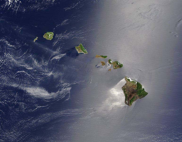
| 解説 | Čeština: Satelitní pohled na Havajské ostrovy English: Satellite view of Hawaii archipelago (USA) Original description from NASA:
Français : Vue satellite de l'archipel d'Hawaï (États-Unis) |
| 日付 | |
| 原典 |
|
| 作者 | Jacques Descloitres |
| その他のバージョン |  |
この画像には画像編集が施されています。原本に対して次のデジタル的な変更が行われました。
|
ライセンス
| このファイルはアメリカ航空宇宙局(NASA)によって作成されたものです。NASAの著作権の方針では、特記事項が無い場合、NASAの資料はパブリックドメインとなります。 (詳しくはTemplate:PD-USGov、NASAの著作権の方針について(英語)又はジェット推進研究所(JPL)の画像使用に関するガイドライン(英語)をご覧ください。) | ||
 | 注意事項:
|
元のアップロードログ
このファイルの派生元: Hawaje.jpg
- File:Hawaje.jpg licensed with PD-USGov-NASA
- 2005-10-26T18:19:43Z Palladinus 3600x2800 (1211908 Bytes) Hawaii Islands
Uploaded with derivativeFX
評価
|
ファイルの履歴
過去の版のファイルを表示するには、その版の日時をクリックしてください。
| 日付と時刻 | サムネイル | 寸法 | 利用者 | コメント | |
|---|---|---|---|---|---|
| 現在の版 | 2010年9月1日 (水) 22:24 | | 3,600 × 2,800 (2.81メガバイト) | IdLoveOne~commonswiki | {{RetouchedPicture|cloned out and healed little red line on the big island|editor=IdLoveOne|orig=Hawaje.jpg}} {{self|PD-USGov-NASA}} == {{Original upload log}} == This image is a derivative work of the following images: *File:Hawaje.jpg licensed w |
ファイルの使用状況
グローバルなファイル使用状況
以下に挙げる他のウィキがこの画像を使っています:
- ace.wikipedia.org での使用状況
- af.wikipedia.org での使用状況
- als.wikipedia.org での使用状況
- ar.wikipedia.org での使用状況
- ary.wikipedia.org での使用状況
- arz.wikipedia.org での使用状況
- ast.wikipedia.org での使用状況
- azb.wikipedia.org での使用状況
- az.wikipedia.org での使用状況
- ba.wikipedia.org での使用状況
- be-tarask.wikipedia.org での使用状況
- bh.wikipedia.org での使用状況
- bn.wikipedia.org での使用状況
- bn.wikibooks.org での使用状況
- ca.wikipedia.org での使用状況
- ceb.wikipedia.org での使用状況
- crh.wikipedia.org での使用状況
- cs.wikipedia.org での使用状況
- cv.wikipedia.org での使用状況
- cy.wikipedia.org での使用状況
- dag.wikipedia.org での使用状況
- de.wikipedia.org での使用状況
- diq.wikipedia.org での使用状況
- el.wikipedia.org での使用状況
- en.wikipedia.org での使用状況
このファイルのグローバル使用状況を表示する。