Bavaria
Bavaria (/bəˈvɛəriə/; German: Bayern, [ˈbaɪɐn]), officially the Free State of Bavaria (German: Freistaat Bayern, [ˈfʁaɪʃtaːt ˈbaɪɐn] (![]() listen); Bavarian: Freistoot Bayern), is a State (Bundesland) of Germany. The territory of this state is the largest of the 16 German states. The state capital is Munich with 1.5 million people. About 13.1 million people live in Bavaria.
listen); Bavarian: Freistoot Bayern), is a State (Bundesland) of Germany. The territory of this state is the largest of the 16 German states. The state capital is Munich with 1.5 million people. About 13.1 million people live in Bavaria.
Free State of Bavaria | |
|---|---|
| Anthem: Bayernhymne (German) "Hymn of Bavaria" | |
 | |
| Coordinates: 48°46′39″N 11°25′52″E / 48.77750°N 11.43111°E | |
| Country | Germany |
| Capital | Munich |
| Government | |
| • Body | Landtag of Bavaria |
| • Minister-President | Markus Söder (CSU) |
| • Governing parties | CSU / FW |
| • Bundesrat votes | 6 (of 69) |
| Area | |
| • Total | 70,550.19 km2 (27,239.58 sq mi) |
| Population (2019-12-31)[1] | |
| • Total | 13,124,737 |
| • Density | 186/km2 (480/sq mi) |
| Demonym | Bavarians |
| Population | |
| • Official languages |
|
| Time zone | UTC+1 (CET) |
| • Summer (DST) | UTC+2 (CEST) |
| ISO 3166 code | DE-BY |
| GRP (nominal) | €633 billion (2019)[2] |
| GRP per capita | €48,000 (2019) |
| NUTS Region | DE2 |
| HDI (2018) | 0.947[3] very high · 6th of 16 |
| Website | https://www.bayern.de |
Like many German states, Bavaria was once independent. Ludwig II of Bavaria was its last independent king. Bavaria joined the German Empire in 1871.
Structure
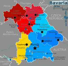
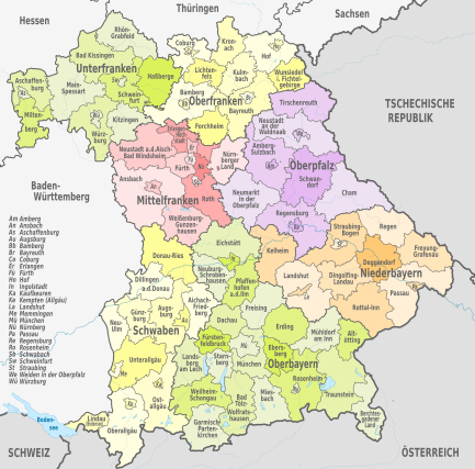
Bavaria has seven parts: Oberbayern (Upper Bavaria), Niederbayern (Lower Bavaria), Schwaben (Swabia), Mittelfranken (Middle Franconia), Unterfranken (Lower Franconia), Oberfranken (Upper Franconia) and Oberpfalz (Upper Palatinate). Bavaria has 71 districts and 25 free cities.
The highest point is the Zugspitze, which is also the highest mountain in Germany. Munich is the largest city, the second biggest city is Nuremberg (Nürnberg), which is famous for its gingerbread, a kind of Christmas bread that is often shaped like a Christmas tree, a snowman or Santa Claus.
Pope Benedict XVI was born in Bavaria.
Administrative divisions
Administrative regions

Bavaria is divided into seven administrative regions called Regierungsbezirke (singular Regierungsbezirk). For every Administrative region there is a state agency called Bezirksregierung (district government).
- Altbayern:
Districts (Bezirke)
Bavaria has "Bezirke" or districts; the others are the Landkreise and the Gemeinden or Städte. The Bezirke in Bavaria are identical with the Regierungsbezirke. In the other larger states of Germany, there are only Regierungsbezirke as administrative divisions and no self-governing entities at the level of the Regierungsbezirke as the Bezirke in Bavaria.
Population and area
| Region | Coat of arms | Capital | Population (2019)[4] | Area (km2) | No. municipalities | |||
|---|---|---|---|---|---|---|---|---|
| Lower Bavaria |  | Landshut | 1,244,169 | 9.48% | 10,330 | 14.6% | 258 | 12.5% |
| Lower Franconia |  | Würzburg | 1,317,619 | 10.46% | 8,531 | 12.1% | 308 | 15.0% |
| Upper Franconia |  | Bayreuth | 1,065,371 | 8.49% | 7,231 | 10.2% | 214 | 10.4% |
| Middle Franconia |  | Ansbach | 1,775,169 | 13.65% | 7,245 | 10.3% | 210 | 10.2% |
| Upper Palatinate |  | Regensburg | 1,112,102 | 8.60% | 9,691 | 13.7% | 226 | 11.0% |
| Swabia |  | Augsburg | 1,899,442 | 14.21% | 9,992 | 14.2% | 340 | 16.5% |
| Upper Bavaria |  | Munich | 4,710,865 | 35.12% | 17,530 | 24.8% | 500 | 24.3% |
| Total | 13,124,737 | 100.0% | 70,549 | 100.0% | 2,056 | 100.0% | ||
Districts
Bavaria is made up of 71 rural districts that are comparable to counties, as well as the 25 independent cities, both of which share the same administrative responsibilities and duties.

Rural districts:
Independent cities:
Municipalities
The 71 rural districts are on the lowest level divided into 2,031 regular municipalities. Together with the 25 independent cities, there are a total of 2,056 municipalities in Bavaria.


In 44 of the 71 rural districts, there are a total of 215 unincorporated areas (as of 1 January 2005), not belonging to any municipality, all unsettled and unpopulated, mostly forested areas, but also four lakes (Chiemsee-without islands, Starnberger See-without islands, Roseninsel, Ammersee, which are the three largest lakes of Bavaria, and Waginger See).
Major cities and towns
| City | Region | Population (2000) | Population (2005) | Population (2010) | Population (2015) | Change (%) |
|---|---|---|---|---|---|---|
| Munich | Upper Bavaria | 1,210,223 | 1,259,677 | 1,353,186 | 1,450,381 | +11.81 |
| Nuremberg | Middle Franconia | 488,400 | 499,237 | 505,664 | 509,975 | +3.53 |
| Augsburg | Swabia | 254,982 | 262,676 | 264,708 | 286,374 | +3.81 |
| Regensburg | Upper Palatinate | 125,676 | 129,859 | 135,520 | 145,465 | +7.83 |
| Ingolstadt | Upper Bavaria | 115,722 | 121,314 | 125,088 | 132,438 | +8.09 |
| Würzburg | Lower Franconia | 127,966 | 133,906 | 133,799 | 124,873 | +4.56 |
| Fürth | Middle Franconia | 110,477 | 113,422 | 114,628 | 124,171 | +3.76 |
| Erlangen | Middle Franconia | 100,778 | 103,197 | 105,629 | 108,336 | +4.81 |
| Bayreuth | Upper Franconia | 74,153 | 73,997 | 72,683 | 72,148 | −1.98 |
| Bamberg | Upper Franconia | 69,036 | 70,081 | 70,004 | 73,331 | +1.40 |
| Aschaffenburg | Lower Franconia | 67,592 | 68,642 | 68,678 | 68,986 | +1.61 |
| Landshut | Lower Bavaria | 58,746 | 61,368 | 63,258 | 69,211 | +7.68 |
| Kempten | Swabia | 61,389 | 61,360 | 62,060 | 66,947 | +1.09 |
| Rosenheim | Upper Bavaria | 58,908 | 60,226 | 61,299 | 61,844 | +4.06 |
| Neu-Ulm | Swabia | 50,188 | 51,410 | 53,504 | 57,237 | +6.61 |
| Schweinfurt | Lower Franconia | 54,325 | 54,273 | 53,415 | 51,969 | −1.68 |
| Passau | Lower Bavaria | 50,536 | 50,651 | 50,594 | 50,566 | +0.11 |
| Freising | Upper Bavaria | 40,890 | 42,854 | 45,223 | 46,963 | +10.60 |
| Straubing | Lower Bavaria | 44,014 | 44,633 | 44,450 | 46,806 | +0.99 |
| Dachau | Upper Bavaria | 38,398 | 39,922 | 42,954 | 46,705 | +11.87 |
Source: Bayerisches Landesamt für Statistik und Datenverarbeitung[5][6]
Notes
References
Sources
- . Encyclopædia Britannica. Vol. 3 (11th ed.). 1911.
Other websites


