Macedonia (Greece)
Macedonia is a historical and geographical region in northern Greece. It is the second most populous region of Greece and usually it is referred as Northern Greece along with Thrace. It is situated between the Pindus Mountains and river Nestos and it borders west with Epirus and Thessaly, northwestern with Albania, north with North Macedonia, northeastern with Bulgaria and east with Thrace. Its south coasts are washed by the Aegean Sea. Macedonia is separated in three smaller peripheries: West Macedonia, Central Macedonia and East Macedonia and Thrace. It has a total population of 2,424,765 inhabitants according to the 2001 census and its total area is 34,177 km². The capital of Macedonia is Thessaloniki and has a population of about 1,000,000 inhabitants. Macedonia's national anthem is Μακεδονία Ξακουστή which means Famous Macedonia.


Geography
Macedonia has many mountains and the tallest is Mount Olympus which has a high of 2,917 meters. There are also many valleys that are some of the biggest in the whole Greece. Rivers such as Aliakmon, Axios, Nestos, and Strymonas cross these valleys and drain into the Aegean Sea.
Prefectures and population
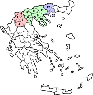
Macedonia consists 13 prefectures and sometimes it is said to be 14 because there is also a monastery region, Mount Athos, which is autonomous.
| Map of Macedonia | Number | Periphery | Capital | Area | Population |
|---|---|---|---|---|---|
 | |||||
| Total | West Macedonia | Kozani | 9,451 km² | 301,522 | |
| 1 | Kastoria Prefecture | Kastoria | 1,720 km² | 53,483 | |
| 2 | Florina Prefecture | Florina | 1,924 km² | 54,768 | |
| 3 | Kozani Prefecture | Kozani | 3,516 km² | 155,324 | |
| 4 | Grevena Prefecture | Grevena | 2,291 km² | 37,947 | |
| Total | Central Macedonia | Thessaloniki | 18,811 km² | 1,871,952 | |
| 5 | Pella Prefecture | Edessa | 2,506 km² | 145,797 | |
| 6 | Imathia Prefecture | Veria | 1,701 km² | 143,618 | |
| 7 | Pieria Prefecture | Katerini | 1,516 km² | 129,846 | |
| 8 | Kilkis Prefecture | Kilkis | 2,519 km² | 89,056 | |
| 9 | Thessaloniki Prefecture | Thessaloniki | 3,683 km² | 1,057,825 | |
| 10 | Chalkidiki Prefecture | Polygyros | 2,918 km² | 104,894 | |
| 11 | Serres Prefecture | Serres | 3.968 km² | 200,916 | |
| Total | East Macedonia (Part of East Macedonia and Thrace) | Kavala | 5,579 km² | 249,029 | |
| 12 | Drama Prefecture (Part of the Drama–Kavala–Xanthi super-prefecture) | Drama | 3,468 km² | 103,975 | |
| 13 | Kavala Prefecture (Part of the Drama–Kavala–Xanthi super-prefecture) | Kavala | 2,111 km² | 145,054 | |
| - | Mount Athos (Autonomous) | Karyes | 336 km² | 2,262 | |
| Total | 'Macedonia' | Thessaloniki | 34,177 km² | 2,424,765[1] |
And the population of the largest towns:


| Towns/Cities | Greek Name | Population |
|---|---|---|
| 01. Thessaloniki (municipality) | Δήμος Θεσσαλονίκης | 363,987 |
| 02. Kavala | Καβάλα | 63,293 |
| 03. Katerini | Κατερίνη | 56,434 |
| 04. Serres | Σέρρες | 56,145 |
| 05. Drama | Δράμα | 55,632 |
| 06. Kozani | Κοζάνη | 47,451 |
| 07. Veria | Βέροια | 47,411 |
| 08. Ptolemaida | Πτολεμαΐδα | 35,539 |
| 09. Giannitsa | Γιαννιτσά | 26,296 |
| 10. Kilkis | Κιλκίς | 24,812 |
| 11. Naousa | Νάουσα | 22,288 |
| 12. Aridaia | Αριδαία | 20,213 |
| 13. Alexandreia | Αλεξάνδρεια | 19,283 |
| 14. Edessa | Έδεσσα | 18,253 |
| 15. Nea Moudania | Νέα Μουδανιά | 17,032 |
| 16. Florina | Φλώρινα | 16,771 |
| 17. Kastoria | Καστοριά | 16,218 |
| 18. Grevena | Γρεβενά | 15,481 |
| 19. Polygyros | Πολύγυρος | 10,721 |
| 20. Skydra | Σκύδρα | 5,081 |
Related pages
- Macedonia
- References
Other websites
- Macedonia, The Historical Profile of Northern Greece
- Macedonia and Thrace region site Archived 2011-07-21 at the Wayback Machine (in English)
- Region of Central Macedonia Archived 2007-10-11 at the Wayback Machine
- Region of Western Macedonia Archived 2014-12-18 at the Wayback Machine
- Region of Eastern Macedonia and Thrace Archived 2005-05-29 at the Wayback Machine