Provence-Alpes-Côte d'Azur
Provence-Alpes-Côte d'Azur or PACA (Occitan: Provença-Aups-Còsta d'Azur, Italian: Provenza-Alpi-Costa Azzurra) is one of the 18 administrative regions of France. Its capital is Marseille.
Provence-Alpes-Côte d'Azur Provença-Aups-Còsta d'Azur (Occitan) | |
|---|---|
 View of Menton | |
 Flag  Coat of arms | |
 | |
| Coordinates: 44°00′N 6°00′E / 44.000°N 6.000°E | |
| Country | |
| Prefecture | Marseille |
| Departments | |
| Government | |
| • President of the Regional Council | Renaud Muselier (DVD) |
| Area | |
| • Total | 31,400 km2 (12,100 sq mi) |
| • Rank | 10th |
| Population (Jan. 2019)[1] | |
| • Total | 5,081,101 |
| • Density | 160/km2 (420/sq mi) |
| Demonym | Provençals |
| Time zone | UTC+01:00 (CET) |
| • Summer (DST) | UTC+02:00 (CEST) |
| ISO 3166 code | FR-PAC |
| GDP (2012)[2] | Ranked 3rd |
| Total | €142.4 billion (US$183.1 bn) |
| Per capita | €28,861 (US$37,121) |
| NUTS Region | FR8 |
| Website | maregionsud.fr |
Geography

The Provence-Alpes-Côte d'Azur region is the tenth largest region of France with an area of 31,399.8 km2 (12,124 sq mi). It is in southeastern France and borders to the east with Monaco and Italy (with the Italian regions of Liguria and Piedmont). To the north is the Auvergne-Rhône-Alpes region and to the west is the Occitanie region.
To the south, the Provence-Alpes-Côte d'Azur has about 900 km (560 mi) of coast along the Mediterranean Sea.[3]
The distances from Marseille, the capital of the region, to other cities are:
- Paris, the national capital, 775 km (482 mi);
- Toulouse, 407 km (253 mi);
- Bordeaux, 645 km (401 mi);
- Lyon, 315 km (196 mi);
- Montpellier, 169 km (105 mi);
- Nice, 203 km (126 mi).
Rivers
The only main drainage basin in the region is the Mediterranean basin; some of the rivers in region are:
Mountains
The Barre des Écrins, at 4,102 m (13,458 ft), is the highest mountain of the Provence-Alpes-Côte d'Azur region.[4] It is in the Écrins National Park (French: Parc national des Écrins), one of the ten French national parks.
The highest point of the different departments in the Provence-Alpes-Côte d'Azur region are:[5]
| Department | Mountain | Elevation |
|---|---|---|
| Alpes-de-Haute-Provence | Aiguille de Chambeyron | 3,412 m (11,194 ft) |
| Hautes-Alpes | Barre des Écrins | 4,102 m (13,458 ft) |
| Alpes-Maritimes | Cime du Gélas | 3,143 m (10,312 ft) |
| Bouches-du-Rhône | Bertagne | 1,041 m (3,415 ft) |
| Var | Mont de Lachens | 1,714 m (5,623 ft) |
| Vaucluse | Mont Ventoux | 1,911 m (6,270 ft) |
Departments
The Provence-Alpes-Côte d'Azur region is formed by 6 departments:
| ISO 3166-2 | Shield | Department | Prefecture | Arr. | Cant. | Comm. | Population (2014)[6] | Area (km²) | Density (Inh./km²) |
|---|---|---|---|---|---|---|---|---|---|
| FR-04 |  | Alpes-de-Haute-Provence | Digne-les-Bains | 4 | 15 | 198 | 161,588 | 6,925.2 | 23.3 |
| FR-05 |  | Hautes-Alpes | Gap | 2 | 15 | 167 | 139,883 | 5,548.7 | 25.2 |
| FR-06 |  | Alpes-Maritimes | Nice | 2 | 27 | 163 | 1,083,312 | 4,298.6 | 252.0 |
| FR-13 |  | Bouches-du-Rhône | Marseille | 4 | 29 | 135 | 2,006,069 | 5,087.5 | 394.3 |
| FR-83 |  | Var | Toulon | 3 | 23 | 153 | 1,038,212 | 5,972.5 | 173.8 |
| FR-84 |  | Vaucluse | Avignon | 3 | 17 | 151 | 554,374 | 3,567.3 | 155.4 |
| Total of the Region | 18 | 126 | 967 | 4,983,438 | 31,399.8 | 158.7 | |||
Arr. = Arrondissements Cant. = Cantons Comm. = Communes
Demographics
The Provence-Alpes-Côte d'Azur region had, in 2014, a population of 4,983,438,[7] with a population density of 158.7 inhabitants/km2.

The main cities with more than 30,000 inhabitants (2014) in the region are:
| INSEE code | City | Department | Population (2014) |
|---|---|---|---|
| 13055 | Marseille | Bouches-du-Rhône | 858,120 |
| 06088 | Nice | Alpes-Maritimes | 343,895 |
| 83137 | Toulon | Var | 165,584 |
| 13001 | Aix-en-Provence | Bouches-du-Rhône | 142,149 |
| 84007 | Avignon | Vaucluse | 92,209 |
| 06004 | Antibes | Alpes-Maritimes | 75,731 |
| 06029 | Cannes | Alpes-Maritimes | 73,744 |
| 83126 | La Seyne-sur-Mer | Var | 64,675 |
| 83069 | Hyères | Var | 56,502 |
| 83061 | Fréjus | Var | 53,511 |
| 13004 | Arles | Bouches-du-Rhône | 52,697 |
| 06069 | Grasse | Alpes-Maritimes | 50,409 |
| 13056 | Martigues | Bouches-du-Rhône | 48,870 |
| 06027 | Cagnes-sur-Mer | Alpes-Maritimes | 47,811 |
| 13005 | Aubagne | Bouches-du-Rhône | 45,128 |
| 13103 | Salon-de-Provence | Bouches-du-Rhône | 44,187 |
| 13047 | Istres | Bouches-du-Rhône | 43,463 |
| 06030 | Le Cannet | Alpes-Maritimes | 42,454 |
| 05061 | Gap | Hautes-Alpes | 40,225 |
| 83050 | Draguignan | Var | 40,054 |
| 13028 | La Ciotat | Bouches-du-Rhône | 35,631 |
| 83118 | Saint-Raphaël | Var | 34,567 |
| 13117 | Vitrolles | Bouches-du-Rhône | 34,236 |
| 13054 | Marignane | Bouches-du-Rhône | 34,154 |
| 83129 | Six-Fours-les-Plages | Var | 33,652 |
Gallery
 Marseille
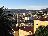 Nice
Nice Toulon
 Aix-en-Provence
 Avignon


Related pages
References
Other websites
- Regional Council websiteArchived 2012-02-07 at the Wayback Machine (in French)
- Prefecture of the region
- Encyclopédie Larousse online (in French)