

Oorspronklike lêer (6 840 × 5 770 piksels, lêergrootte: 14,13 MG, MIME-tipe: image/jpeg)
Hierdie lêer kom vanaf Wikimedia Commons en kan ook in ander projekte gebruik word.Die beskrywing op die lêer se inligtingsblad word hieronder weergegee.
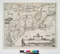
| Nicolaes Visscher: Map of New Netherland and New England, and also parts of Virginia ( | ||||||||||||||||||||||||||
|---|---|---|---|---|---|---|---|---|---|---|---|---|---|---|---|---|---|---|---|---|---|---|---|---|---|---|
| Kunstenaar/Skepper |
artist QS:P170,Q1986270 | |||||||||||||||||||||||||
| Titel | Latyn: Novi Belgii Novæque Angliæ nec non partis Virginiæ tabula Map of New Netherland and New England, and also parts of Virginia title QS:P1476,la:"Novi Belgii Novæque Angliæ nec non partis Virginiæ tabula" label QS:Lla,"Novi Belgii Novæque Angliæ nec non partis Virginiæ tabula" label QS:Len,"Map of New Netherland and New England, and also parts of Virginia" | |||||||||||||||||||||||||
| Beskrywing | English: *Stokes, Iconography, p. 147 (vol. 1), lists dates as 1651-55.
| |||||||||||||||||||||||||
| Datum | Original map in 1656; this is a reprint from 1685 | |||||||||||||||||||||||||
| Inskripsies | Novi Belgii Novæque Angliæ nec non partis Virginiæ tabula [Map of New Netherland and New England, and also parts of Virginia]multis in locis emendata [improved in many places]per Nicolaum Visscher nunc apud Petr. Schenk Iun. [by Nicolaes Visscher, now by Petrus Schenk Junior] | |||||||||||||||||||||||||
| Opmerkings | For a short description (in German) see the article Nieuw Nederland in the German Wikipedia. | |||||||||||||||||||||||||
| Bron/Fotograaf |
| |||||||||||||||||||||||||
| Ander weergawes |
| |||||||||||||||||||||||||
| Reprinted by InfoField |
creator QS:P170,Q124902 Petrus Schenk Junior | |||||||||||||||||||||||||
This is a faithful photographic reproduction of a two-dimensional, public domain work of art. The work of art itself is in the public domain for the following reason:
The official position taken by the Wikimedia Foundation is that "faithful reproductions of two-dimensional public domain works of art are public domain". This photographic reproduction is therefore also considered to be in the public domain in the United States. In other jurisdictions, re-use of this content may be restricted; see Reuse of PD-Art photographs for details. | |||||
Klik op die datum/tyd om te sien hoe die lêer destyds gelyk het.
| Datum/Tyd | Duimnael | Dimensies | Gebruiker | Opmerking | |
|---|---|---|---|---|---|
| huidig | 10:00, 2 Oktober 2013 | | 6 840 × 5 770 (14,13 MG) | Joop Rotte | Groter plaatje |
| 15:35, 25 Desember 2004 |  | 2 592 × 2 184 (1,04 MG) | Moyogo | Map of the New Netherland and New England (1685?) - Large version |
Die volgende bladsy gebruik dié lêer:
Die volgende ander wiki's gebruik hierdie lêer:
Wys meer globale gebruik van die lêer.
Die lêer bevat aanvullende inligting wat moontlik deur 'n digitale kamera of skandeerder bygevoeg is.
As die lêer verander is, sal sekere inligting dalk nie meer ooreenkom met dié van die gewysigde lêer nie.
| Oriëntasie | Normaal |
|---|---|
| Horisontale resolusie | 72 dpi |
| Vertikale resolusie | 72 dpi |
| Sagteware gebruik | Adobe Photoshop 7.0 |
| Tydstip laaste lêerwysiging | 11:57, 2 Oktober 2013 |
| Kleurruimte | Nie gekalibreer |


_by_Justus_Danckerts_c1673.jpg)
.jpg)


.jpg)
.jpg)
.jpg)