Plik:Karst following phosphate mining on Nauru.jpg
Rozmiar podglądu – 800 × 535 pikseli. Inne rozdzielczości: 320 × 214 pikseli | 640 × 428 pikseli | 1024 × 684 pikseli | 1280 × 855 pikseli | 1787 × 1194 pikseli.
Rozmiar pierwotny (1787 × 1194 pikseli, rozmiar pliku: 835 KB, typ MIME: image/jpeg)
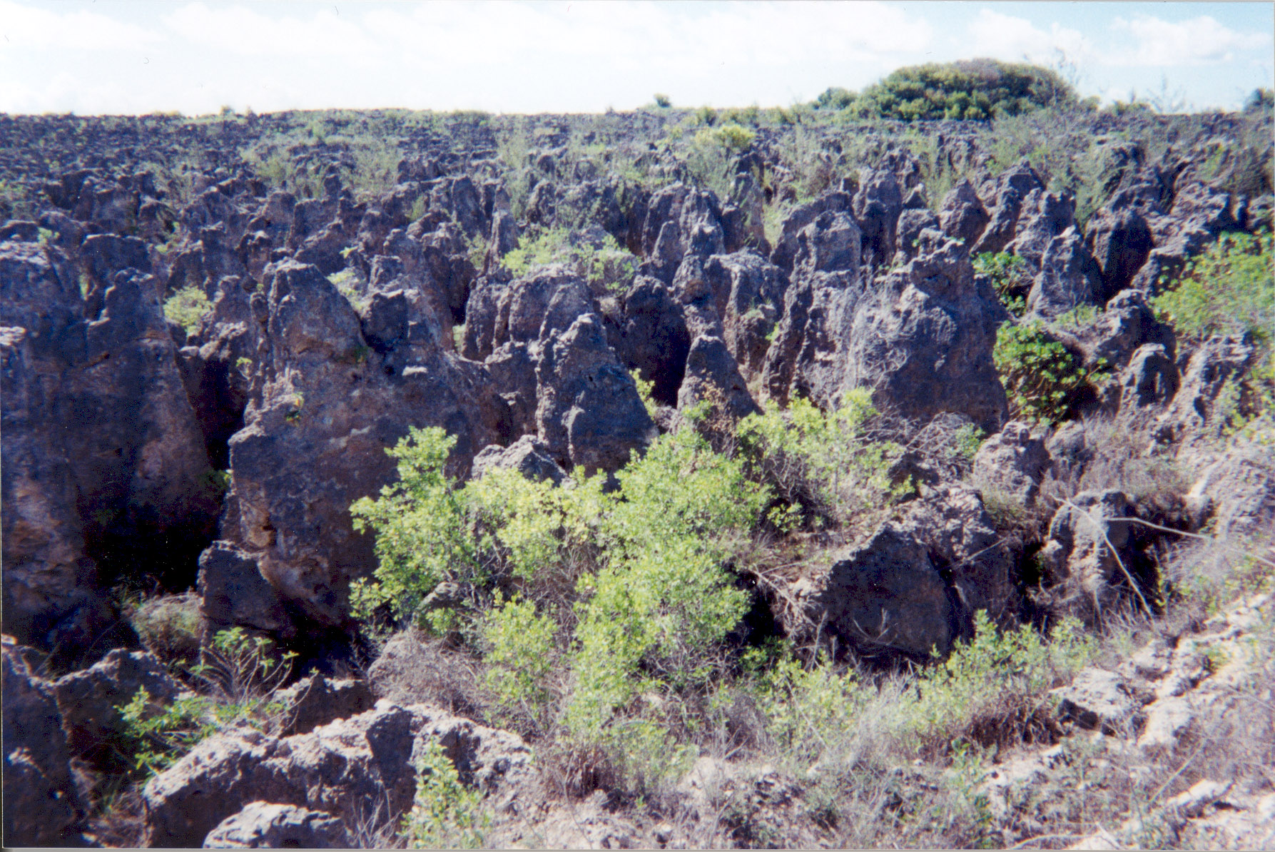
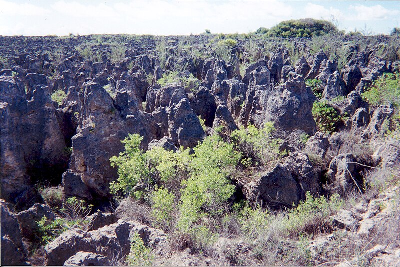
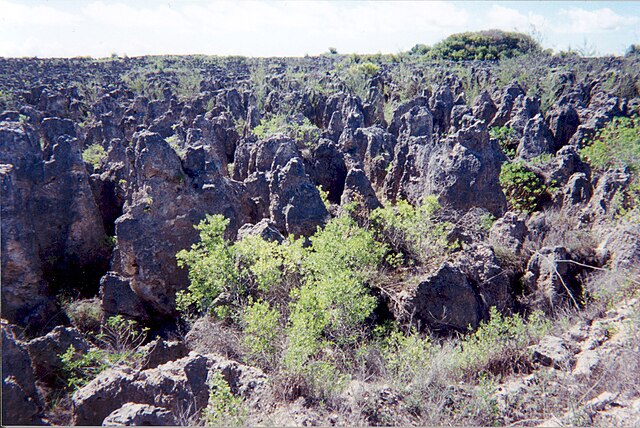
A limestone karst on Nauru Island as a result of the over-mining of phosphate.
Source: [1] (http://www.arm.gov/)
This photograph was produced by the Atmospheric Radiation Measurement Program. Their site states:
|
Historia pliku
Kliknij na datę/czas, aby zobaczyć, jak plik wyglądał w tym czasie.
| Data i czas | Miniatura | Wymiary | Użytkownik | Opis | |
|---|---|---|---|---|---|
| aktualny | 04:10, 3 kwi 2007 | | 1787 × 1194 (835 KB) | Indolences | |
| 07:21, 5 maj 2006 |  | 480 × 321 (75 KB) | PDH | Nauruan districts of Denigomodu and Nibok. ''Courtesy: U.S. Department of Energy's Atmospheric Radiation Measurement Program.'' Source: [http://images.arm.gov/armimages.nsf/a89ad461c472386388256cf3007aeb57/500d8248a90eea9488256cc400727e96?OpenDocument&H |
Lokalne wykorzystanie pliku
Następujące strony korzystają z tego pliku:
Globalne wykorzystanie pliku
Ten plik jest wykorzystywany także w innych projektach wiki:
- Wykorzystanie na az.wikipedia.org
- Wykorzystanie na bg.wikipedia.org
- Wykorzystanie na bh.wikipedia.org
- Wykorzystanie na ca.wikipedia.org
- Wykorzystanie na de.wikipedia.org
- Wykorzystanie na el.wikipedia.org
- Wykorzystanie na en.wikipedia.org
- Wykorzystanie na en.wikiquote.org
- Wykorzystanie na eo.wikipedia.org
- Wykorzystanie na es.wikipedia.org
- Wykorzystanie na eu.wikipedia.org
- Wykorzystanie na fa.wikipedia.org
- Wykorzystanie na fr.wikipedia.org
- Wykorzystanie na ha.wikipedia.org
- Wykorzystanie na he.wikipedia.org
- Wykorzystanie na id.wikipedia.org
- Wykorzystanie na ig.wikipedia.org
- Wykorzystanie na ja.wikipedia.org
- Wykorzystanie na mk.wikipedia.org
- Wykorzystanie na mt.wikipedia.org
- Wykorzystanie na na.wikipedia.org
- Wykorzystanie na new.wikipedia.org
- Wykorzystanie na pt.wikipedia.org
- Wykorzystanie na ro.wikipedia.org
- Wykorzystanie na ru.wikipedia.org
- Wykorzystanie na si.wikipedia.org
- Wykorzystanie na sv.wikipedia.org
- Wykorzystanie na tr.wikipedia.org
- Wykorzystanie na uk.wikipedia.org
- Wykorzystanie na vi.wikipedia.org
- Wykorzystanie na www.wikidata.org
Pokaż listę globalnego wykorzystania tego pliku.
Metadane
🔥 Top keywords: Wikipedia:Strona głównaSpecjalna:SzukajLiga Mistrzów UEFAFacebookKotyninaYouTubeSzczepan TwardochIzabela BodnarJadwiga StaniszkisWho put Bella in the Wych Elm?Jacek ProtasiewiczPolskaDubajCarlo AncelottiReal MadrytLiga Mistrzów UEFA (2023/2024)Ninja Warrior PolskaIranKatarzyna KotulaFallout (seria)IzraelStanisław DerehajłoAndrij Łunin17 kwietniaKlaudiusz ŠevkovićRobert MazurekBrama (ryba)Zmarli w kwietniu 2024Czarny RomanII wojna światowaPep GuardiolaAdolf HitlerFentanylŁukasz GibałaCzernihówRobert LewandowskiPokolenie ZWarszawaXHamster