Indiana
Ìkan lára àwọn ìpínlẹ̀ ní orílé-èdè ìṣọ̀kan Amẹ́ríkà
| State of Indiana | |||||
| |||||
| Ìlàjẹ́: The Hoosier State | |||||
| Motto(s): The Crossroads of America | |||||
 | |||||
| Èdè oníibiṣẹ́ | English | ||||
| Orúkọaráàlú | Hoosier [1] | ||||
| Olúìlú | Indianapolis | ||||
| Ìlú atóbijùlọ | Indianapolis | ||||
| Largest metro area | Indianapolis Metropolitan Area | ||||
| Àlà | Ipò 38th ní U.S. | ||||
| - Total | 36,418 sq mi (94,321 km2) | ||||
| - Width | 140 miles (225 km) | ||||
| - Length | 270 miles (435 km) | ||||
| - % water | 1.5 | ||||
| - Latitude | 37° 46′ N to 41° 46′ N | ||||
| - Longitude | 84° 47′ W to 88° 6′ W | ||||
| Iyeèrò | Ipò 16th ní U.S. | ||||
| - Total | 6,376,792 (2008 est.)[2] | ||||
| - Density | 169.5/sq mi (65.46/km2) Ranked 17th in the U.S. | ||||
| Elevation | |||||
| - Highest point | Hoosier Hill Wayne County[3] 1,257 ft (383 m) | ||||
| - Mean | 689 ft (210 m) | ||||
| - Lowest point | Ohio River and mouth of Wabash River Posey County[3] 320 ft (98 m) | ||||
| Admission to Union | December 11, 1816 (19th) | ||||
| Gómìnà | Eric Holcomb (R) | ||||
| Ìgbákejì Gómìnà | Suzanne Crouch (R) | ||||
| Legislature | {{{Legislature}}} | ||||
| - Upper house | {{{Upperhouse}}} | ||||
| - Lower house | {{{Lowerhouse}}} | ||||
| U.S. Senators | Joe Donnelly (D) Todd Young (R) | ||||
| U.S. House delegation | 5 Democrats, 4 Republicans (list) | ||||
| Time zones | |||||
| - 80 counties | Eastern UTC-5/-4 | ||||
| - 12 counties in Evansville and Gary Metro Areas | Central: UTC-6/-5 | ||||
| Abbreviations | IN US-IN | ||||
| Website | in.gov | ||||
Indiana State Symbols | |
|---|---|
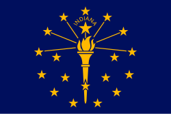
 | |
| The flag of Indiana. | |
| Animate insignia | |
| Bird | Cardinal |
| Flower | Peony |
| Tree | Tulip tree |
| Inanimate insignia | |
| Beverage | Water |
| Poem | "Indiana" |
| Slogan(s) | Restart your Engines |
| Soil | Miami |
| Song(s) | "On the Banks of the Wabash, Far Away" |
| Route marker(s) | |
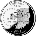
| State Quarter | |
| Released in 2002 | |
| Lists of United States state insignia | |
 | Àyọkà yìí tàbí apá rẹ̀ únfẹ́ àtúnṣe sí. Ẹ le fẹ̀ jù báyìí lọ tàbí kí ẹ ṣàtúnṣe rẹ̀ lọ́nà tí yíò mu kúnrẹ́rẹ́. Ẹ ran Wikipedia lọ́wọ́ láti fẹ̀ẹ́ jù báyìí lọ. |
🔥 Top keywords: Ojúewé Àkọ́kọ́Wikipedia:Nípa WikipediaOgun Àgbáyé Ẹlẹ́ẹ̀kejìWikipedia:Èbúté ÀwùjọÈbúté:Àwọn ìṣẹ̀lẹ̀ ìwòyíPàtàkì:SearchWikipediaÀsà oge ṣíṣẹ́ ní ilè yorùbáỌ̀rọ̀-Orúkọ (Èdè Yorùbá)Èdè YorùbáÀṣà YorùbáÀwọn ọmọ Áfíríkà Amẹ́ríkàFáìlì:Adeniran Ogunsanya.jpgBobriskyWikipedia:Abẹ́ igiPraguePàtàkì:ÀwọnÀtúnṣeTuntunLinda IkejiWikipedia:Àyọkà pàtàkìPàtàkì:ÀwọnÀfikúnMiMọ́remí ÁjàṣoroFáwẹ̀lì YorùbáPornhubOwe YorubaÀmìọ̀rọ̀ QREre idarayaISO 8601Ògún LákáayéOrúkọ YorùbáÈdè Gẹ̀ẹ́sìIṣẹ́ Àgbẹ̀OSI modelIlẹ̀ọba Aṣọ̀kanẸ̀ka:Àwọn Àyọkà pẹ̀lú ìjúwe ṣókíÌgbéyàwóHTMLKikan Jesu mo igi agbelebuÀrokòISBN


