Plik:Aerial view of Nauru.jpg
Rozmiar podglądu – 800 × 587 pikseli. Inne rozdzielczości: 320 × 235 pikseli | 640 × 469 pikseli | 1024 × 751 pikseli | 1280 × 938 pikseli | 1600 × 1173 pikseli.
Rozmiar pierwotny (1600 × 1173 pikseli, rozmiar pliku: 545 KB, typ MIME: image/jpeg)
Opis
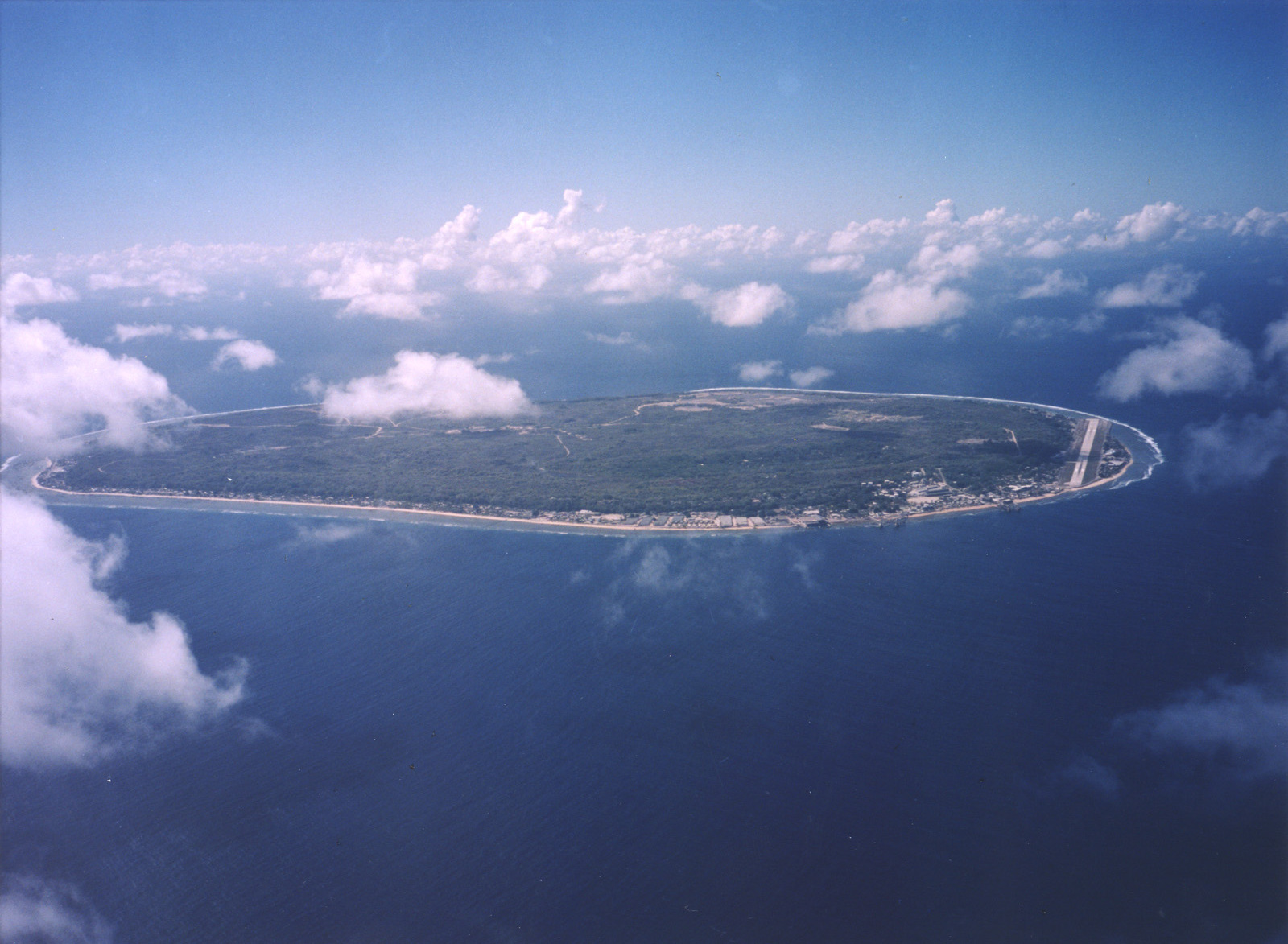
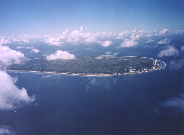
| Opis | English: A limestone karst on Nauru Island as a result of the over-mining of phosphate. |
| Data | |
| Źródło | https://www.flickr.com/photos/armgov/4708951747/ |
| Autor | U.S. Department of Energy's Atmospheric Radiation Measurement Program |
Licencja
This photograph was produced by the Atmospheric Radiation Measurement Program. Their site states:
|
Historia pliku
Kliknij na datę/czas, aby zobaczyć, jak plik wyglądał w tym czasie.
| Data i czas | Miniatura | Wymiary | Użytkownik | Opis | |
|---|---|---|---|---|---|
| aktualny | 00:53, 29 kwi 2023 | | 1600 × 1173 (545 KB) | Auguel | Cropped 1 % vertically using CropTool with lossless mode. |
| 04:13, 3 kwi 2007 |  | 1600 × 1187 (401 KB) | Indolences | A limestone karst on Nauru Island as a result of the over-mining of phosphate. ''Courtesy: U.S. Department of Energy's Atmospheric Radiation Measurement Program.'' Source: [http://images.arm.gov/armimages.nsf/by+id/TENG-5JGSKP] (http://www.arm.gov/) {{ |
Lokalne wykorzystanie pliku
Następujące strony korzystają z tego pliku:
Globalne wykorzystanie pliku
Ten plik jest wykorzystywany także w innych projektach wiki:
- Wykorzystanie na ar.wikipedia.org
- Wykorzystanie na as.wikipedia.org
- Wykorzystanie na bg.wikipedia.org
- Wykorzystanie na de.wikipedia.org
- Wykorzystanie na dsb.wikipedia.org
- Wykorzystanie na en.wikipedia.org
- Wykorzystanie na en.wikiversity.org
- Wykorzystanie na es.wikipedia.org
- Wykorzystanie na fr.wikipedia.org
- Wykorzystanie na fr.wiktionary.org
- Wykorzystanie na he.wikivoyage.org
- Wykorzystanie na hsb.wikipedia.org
- Wykorzystanie na hu.wikipedia.org
- Wykorzystanie na hy.wikipedia.org
- Wykorzystanie na id.wikipedia.org
- Wykorzystanie na incubator.wikimedia.org
- Wykorzystanie na lv.wikipedia.org
- Wykorzystanie na ms.wikipedia.org
- Wykorzystanie na na.wikipedia.org
- Wykorzystanie na nl.wikivoyage.org
- Wykorzystanie na pt.wikivoyage.org
- Wykorzystanie na ru.wikipedia.org
- Wykorzystanie na ru.wikivoyage.org
- Wykorzystanie na simple.wikipedia.org
- Wykorzystanie na si.wikipedia.org
- Wykorzystanie na ta.wikipedia.org
- Wykorzystanie na test.wikipedia.org
- Wykorzystanie na th.wikipedia.org
- Wykorzystanie na tr.wikipedia.org
- Wykorzystanie na uk.wikipedia.org
- Wykorzystanie na vec.wikipedia.org
- Wykorzystanie na vi.wikipedia.org
- Wykorzystanie na vi.wikivoyage.org
Metadane
🔥 Top keywords: Wikipedia:Strona głównaSpecjalna:SzukajLiga Mistrzów UEFAFacebookKotyninaYouTubeSzczepan TwardochIzabela BodnarJadwiga StaniszkisWho put Bella in the Wych Elm?Jacek ProtasiewiczPolskaDubajCarlo AncelottiReal MadrytLiga Mistrzów UEFA (2023/2024)Ninja Warrior PolskaIranKatarzyna KotulaFallout (seria)IzraelStanisław DerehajłoAndrij Łunin17 kwietniaKlaudiusz ŠevkovićRobert MazurekBrama (ryba)Zmarli w kwietniu 2024Czarny RomanII wojna światowaPep GuardiolaAdolf HitlerFentanylŁukasz GibałaCzernihówRobert LewandowskiPokolenie ZWarszawaXHamster