Fitxategi:MODIS Map.jpg

Aurreikuspen honen neurria: 800 × 400 pixel. Bestelako bereizmenak: 320 × 160 pixel | 640 × 320 pixel | 1.024 × 512 pixel | 1.280 × 640 pixel | 2.560 × 1.280 pixel | 5.400 × 2.700 pixel.
Bereizmen handikoa ((5.400 × 2.700 pixel, fitxategiaren tamaina: 11,84 MB, MIME mota: image/jpeg))
Fitxategi hau Wikimedia Commonsekoa da. Hango deskribapen orriko informazioa behean duzu. |
|

Laburpena
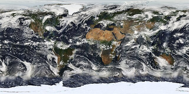
| Deskribapena | English: This image is based largely on observations from the Moderate Resolution Imaging Spectroradiometer (MODIS) - a sensor aboard the Terra satellite - on July 11, 2005. Small gaps in MODIS' coverage between overpasses, as well as Antarctica (which is in polar darkness in July), have been filled in using GOES weather satellites and the latest version of the NASA Blue Marble. Hurricane Dennis can be seen moving inland over the Gulf Coast. Français : Planisphère montrant la terre telle qu'elle a été observée par le satellite MODIS le 11 juillet 2005. Les petits trous dans la couveture de MODIS ont été comblés avec des données provenant des satellites GOES, et la dernière version de la Blue marble (bille bleue) de la NASA. Italiano: Una foto satellitare della superficie terrestre, elaborata, in larga parte, dalle immagini fornite dalle fotocamere MODIS che equipaggiano i satelliti per telerilevamento Aqua (EOS PM-1) e Terra (EOS AM-1). Русский: Изображение, созданное главным образом по данным сканирующего спутникового спектрорадиометра MODIS (2005-07-11.) Небольшие «пропуски» между покрытиями прибора, а также Антарктика, были восстановлены с использованием данных метеоспутников GOES и последней версии «голубого мрамора» NASA. |
| Data | Taken on 2005ko uztailaren 11 |
| Jatorria | Earth's Vital Signs |
| Egilea | NASA |
| Beste bertsioak |
|


Lizentzia
| This file is in the public domain in the United States because it was solely created by NASA. NASA copyright policy states that "NASA material is not protected by copyright unless noted". (See Template:PD-USGov, NASA copyright policy page or JPL Image Use Policy.) | ||
 | Warnings:
|
Fitxategiaren historia
Data/orduan klik egin fitxategiak orduan zuen itxura ikusteko.
| Data/Ordua | Iruditxoa | Neurriak | Erabiltzailea | Iruzkina | |
|---|---|---|---|---|---|
| oraingoa | 12:47, 25 otsaila 2010 | | 5.400 × 2.700 (11,84 MB) | Originalwana | {{Information |Description={{en|1=Image based largely on observations from the Moderate Resolution Imaging Spectroradiometer (MODIS). Small gaps in MODIS’ coverage between overpasses, as well as Antarctica, have been filled in using [[:Category:Geos |
Irudira dakarten loturak
Hurrengo orrialdeek dute fitxategi honetarako lotura:
Fitxategiaren erabilera orokorra
Hurrengo beste wikiek fitxategi hau darabilte:
- af.wikipedia.org proiektuan duen erabilera
- ar.wikipedia.org proiektuan duen erabilera
- ba.wikipedia.org proiektuan duen erabilera
- be.wikipedia.org proiektuan duen erabilera
- bh.wikipedia.org proiektuan duen erabilera
- bn.wikipedia.org proiektuan duen erabilera
- bn.wikibooks.org proiektuan duen erabilera
- ca.wikipedia.org proiektuan duen erabilera
- crh.wikipedia.org proiektuan duen erabilera
- cs.wikipedia.org proiektuan duen erabilera
- cv.wikipedia.org proiektuan duen erabilera
- en.wikipedia.org proiektuan duen erabilera
- Cloud cover
- Moderate Resolution Imaging Spectroradiometer
- User talk:Nauticashades
- Talk:Cloud cover
- Wikipedia:Featured pictures/Space/Looking back
- Wikipedia:Featured pictures thumbs/23
- Wikipedia:Featured picture candidates/June-2010
- Wikipedia:Featured picture candidates/MODIS Cloud Cover Map
- Wikipedia:Wikipedia Signpost/2010-06-14/Features and admins
- Portal:Climate change/Selected picture
- Portal:Climate change/Selected picture/12
- Wikipedia:Picture of the day/January 2012
- Template:POTD/2012-01-01
- Wikipedia:Main Page history/2012 January 1
- User:AvionArchon/sandbox
- Wikipedia:Wikipedia Signpost/Single/2010-06-14
- User:Darth Tacker/TWA/Earth
- User:CheChe/Spoken Script
- User:Zanygenius/TWA/Earth
- User:Zanygenius/TWA/Earth/2
- User:Google7722/TWA/Earth
- es.wikipedia.org proiektuan duen erabilera
- et.wikipedia.org proiektuan duen erabilera
- fa.wikipedia.org proiektuan duen erabilera
- fa.wikibooks.org proiektuan duen erabilera
- fi.wikipedia.org proiektuan duen erabilera
- fr.wikipedia.org proiektuan duen erabilera
Ikus fitxategi honen erabilpen global gehiago.
Metadatuak
🔥 Top keywords: Berezi:BilatuAzalaTxikipedia:AzalaCarles PuigdemontGonzalo BoyePello OtxandianoBerezi:AzkenAldaketakMaria AntonietaMikel AnteroNerea KortajarenaEuskaraWikipediaTxikipedia:LaukiCastillo SuarezGalicia (L-51)Euskal HerriaIhes beteaEneko AnduezaSarpenBigarren Mundu GerraTxikipediaPaleolitoaMetalLaguntza:Wikipediari buruzCreative CommonsNagore AranburuTraineru estropadaPaulo AzpiazuHaurdunaldiImanol PradalesArrainketariakArotzaren eskuakApirilaren 17Laguntza:SarreraTaula periodikoaTxikipedia:IgelTxikipedia:PaleolitoaOihana EtxebarrietaEuskadi Ta Askatasuna