Fitxategi:Map showing counties under the new Kenyan constitution.gif

Bereizmen handikoa ((620 × 804 pixel, fitxategiaren tamaina: 56 KB, MIME mota: image/gif))
Fitxategi hau Wikimedia Commonsekoa da. Hango deskribapen orriko informazioa behean duzu. |
Laburpena
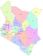
| Deskribapena | English: Areas that are covered by Counties in the new Kenya constitution |
| Data | |
| Jatorria | https://opendata.go.ke/facet/counties |
| Egilea | Kenya Open Data Project |
Lizentzia
 | The copyright holder of this work allows anyone to use it for any purpose including unrestricted redistribution, commercial use, and modification.
Usage notes:
|
All the works in the Kenya open data website are free for use either commercially or non commercially as it is stated at the terms and conditions of the website. I believe that this is a non commercial use on commons.
Fitxategiaren historia
Data/orduan klik egin fitxategiak orduan zuen itxura ikusteko.
| Data/Ordua | Iruditxoa | Neurriak | Erabiltzailea | Iruzkina | |
|---|---|---|---|---|---|
| oraingoa | 08:48, 28 ekaina 2012 | | 620 × 804 (56 KB) | Kagundu |
Irudira dakarten loturak
Hurrengo orrialdeek dute fitxategi honetarako lotura:
Fitxategiaren erabilera orokorra
Hurrengo beste wikiek fitxategi hau darabilte:
- ab.wikipedia.org proiektuan duen erabilera
- ba.wikipedia.org proiektuan duen erabilera
- bg.wikipedia.org proiektuan duen erabilera
- bs.wikipedia.org proiektuan duen erabilera
- cs.wikipedia.org proiektuan duen erabilera
- cy.wikipedia.org proiektuan duen erabilera
- en.wikipedia.org proiektuan duen erabilera
- eo.wikipedia.org proiektuan duen erabilera
- et.wikipedia.org proiektuan duen erabilera
- fa.wikipedia.org proiektuan duen erabilera
- fi.wikipedia.org proiektuan duen erabilera
- fr.wikipedia.org proiektuan duen erabilera
- he.wikipedia.org proiektuan duen erabilera
- hu.wikipedia.org proiektuan duen erabilera
- id.wikipedia.org proiektuan duen erabilera
- incubator.wikimedia.org proiektuan duen erabilera
- it.wikipedia.org proiektuan duen erabilera
- ko.wikipedia.org proiektuan duen erabilera
- ku.wikipedia.org proiektuan duen erabilera
- my.wikipedia.org proiektuan duen erabilera
- pl.wikipedia.org proiektuan duen erabilera
- ru.wikipedia.org proiektuan duen erabilera
- Кения
- Ньянза
- Западная провинция (Кения)
- Рифт-Валли
- Северо-Восточная провинция (Кения)
- Центральная провинция (Кения)
- Прибрежная провинция (Кения)
- Восточная провинция (Кения)
- Бусиа (округ, Кения)
- Найроби (провинция Кении)
- Административное деление Кении
- Гарисса (округ)
- Нарок (округ)
- Ваджир (округ)
- Шаблон:Административное деление Кении
- Занзойский округ
- Вихига (округ)
- Западный покотский округ
- Исиоло (округ)
Ikus fitxategi honen erabilpen global gehiago.