Saba
island in the Caribbean, part of the Netherlands
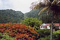
Saba (spoken as "Sah-ba") is the smallest island of the Caribbean Netherlands and the former Netherlands Antilles. It is a special municipality (public body) of the Netherlands. It lies at 17°38′N 63°14′W / 17.633°N 63.233°W. It is mostly made up of Mount Scenery (877 m), the highest point of the Kingdom of the Netherlands. Scenery is a dormant volcano.
Saba | |
|---|---|
Special municipality of the Netherlands | |
 Flag  Coat of arms | |
| Motto(s): | |
| Anthem: "Saba you rise from the ocean" | |
 | |
 Map showing location of Saba relative to Sint Eustatius and Saint Martin. | |
| Coordinates: 17°37′57″N 63°14′15″W / 17.63250°N 63.23750°W | |
| Country | |
| Overseas region | Caribbean Netherlands |
| Incorporated into the Netherlands | 10 October 2010 (dissolution of the Netherlands Antilles) |
| Capital (and largest city) | The Bottom |
| Government | |
| • Lt. Governor | Jonathan Johnson |
| Area | |
| • Total | 13 km2 (5 sq mi) |
| Population (1 January 2022)[2] | |
| • Total | 1,911 |
| • Density | 148/km2 (380/sq mi) |
| Demonym | Saban |
| Languages | |
| • Official | Dutch |
| • Recognised regional | English[3] |
| Ethnicity | |
| • Saban | 26.6 % |
| • Sint Maarten | 15.7 % |
| • American | 10.0 % |
| • other | 47.7 % |
| Time zone | UTC−4 (AST) |
| Calling code | +599-4 |
| ISO 3166 code | BQ-SA, NL-BQ2 |
| Currency | United States dollar ($) (USD) |
| Internet TLD | |
Saba has a land area of 13 km² (5 sq. miles). At the 2001 Netherlands Antilles census, 1,349 people lived there. In 2004, about 1,424 people lived there.
Gallery
 Hawksbill Turtle
 Saba's airport


Notes
References
Other websites
![]()
![]() Media related to Saba at Wikimedia Commons
Media related to Saba at Wikimedia Commons
- Saba's Tourist Bureau homepage
- Saba Conservation Foundation's homepage
- Saba Ferry Dawn II
- Saba (N.A.): Bos en nationale parken. 54pp. Archived 2016-03-03 at the Wayback Machine
- Saba University School of Medicine
 This short article about a place or feature can be made longer. You can help Wikipedia by adding to it.
🔥 Top keywords: Main PageSpecial:Search0Slash (punctuation)BlackSpecial:RecentChanges4 (number)DavidSOLID (object-oriented design)Wikipedia:AboutFile:Sexual intercourse with internal ejaculation.webmHelp:ContentsHelp:IntroductionLisa Sparxxx2023 UEFA Champions League FinalColour24-hour clockAdolf Hitler UunonaBismillahir Rahmanir Raheem6 (number)T. N. SeshanFile:ASCII-Table-wide.svg20 (number)Poor Things (movie)United StatesCristiano RonaldoList of people who have walked on the MoonAli Malikov50 (number)17 (number)The Valley (2024 TV series)GrassList of mathematical symbolsList of U.S. states and territories by time zone8 (number)List of countries by areaWikipedia:Simple talkList of largest Hindu templesRama