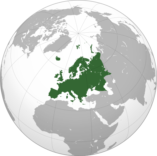
ไฟล์:Europe orthographic Caucasus Urals boundary.svg

ขนาดของตัวอย่าง PNG นี้ของไฟล์ SVG นี้: 537 × 536 พิกเซล ความละเอียดอื่น: 240 × 240 พิกเซล | 481 × 480 พิกเซล | 769 × 768 พิกเซล | 1,026 × 1,024 พิกเซล | 2,052 × 2,048 พิกเซล
ดูภาพที่มีความละเอียดสูงกว่า ((ไฟล์ SVG, 537 × 536 พิกเซล, ขนาดไฟล์: 77 กิโลไบต์))
ประวัติไฟล์
คลิกวันที่/เวลาเพื่อดูไฟล์ที่ปรากฏในขณะนั้น
| วันที่/เวลา | รูปย่อ | ขนาด | ผู้ใช้ | ความเห็น | |
|---|---|---|---|---|---|
| ปัจจุบัน | 20:32, 4 กันยายน 2565 |  | 537 × 536 (77 กิโลไบต์) | M.Bitton | Reverted to version as of 12:03, 4 September 2022 (UTC): per COM:OVERWRITE |
| 20:30, 4 กันยายน 2565 |  | 537 × 536 (177 กิโลไบต์) | Рагин1987 | Small correction | |
| 19:03, 4 กันยายน 2565 |  | 537 × 536 (77 กิโลไบต์) | M.Bitton | Reverted to version as of 05:48, 12 March 2019 (UTC): per COM:OVERWRITE + fake svg | |
| 02:12, 31 สิงหาคม 2565 |  | 2,052 × 2,048 (874 กิโลไบต์) | Рагин1987 | More correct visualization of the dividing line on the territory of the Caucasus Range | |
| 12:48, 12 มีนาคม 2562 |  | 537 × 536 (77 กิโลไบต์) | AndreyKva | Optimized. | |
| 02:25, 4 มีนาคม 2559 |  | 537 × 536 (197 กิโลไบต์) | Denniss | Reverted to version as of 13:27, 19 October 2014 (UTC) | |
| 01:37, 4 มีนาคม 2559 |  | 537 × 536 (239 กิโลไบต์) | Ercwlff | UC UC UC | |
| 20:27, 19 ตุลาคม 2557 |  | 537 × 536 (197 กิโลไบต์) | Deni Mataev | Again, The entirety of Georgia is not in Europe geographically, only North Eastern parts are | |
| 03:05, 19 ตุลาคม 2557 |  | 537 × 536 (238 กิโลไบต์) | Politologia | Reverted to version as of 10:57, 18 October 2014 In all maps Georgia is part of Georgia. There is at list 10 versions of borders of Europe in most of them Georgia is part of Europa | |
| 03:04, 19 ตุลาคม 2557 |  | 537 × 536 (238 กิโลไบต์) | Politologia | Reverted to version as of 10:57, 18 October 2014 In all maps Georgia is part of Georgia. |
หน้าที่มีภาพนี้
หน้าต่อไปนี้ โยงมาที่ภาพนี้:
- ทวีป
- ทวีปมู
- ทวีปยุโรป
- ทวีปยูเรเชีย
- ทวีปออสเตรเลีย
- ทวีปอเมริกา
- ทวีปอเมริกาเหนือ
- ทวีปอเมริกาใต้
- ทวีปเอเชีย
- ทวีปแอนตาร์กติกา
- ทวีปแอฟริกา
- ทวีปแอฟโฟร-ยูเรเชีย
- ภูมิภาค
- มหาทวีป
- มหาทวีปกอนด์วานา
- มหาทวีปลอเรเชีย
- มหาทวีปแพนเจีย
- รายชื่อผู้ครองตำแหน่งแมนฮันต์อินเตอร์เนชันแนล
- โลกเก่า
- โอเชียเนีย
- ผู้ใช้:Mr.nana/สมุดจด 3
- วิกิพีเดีย:แม่แบบรายชื่อประเทศแบ่งตามทวีป
- แม่แบบ:ทวีป
การใช้ไฟล์ข้ามโครงการ
วิกิอื่นต่อไปนี้ใช้ไฟล์นี้:
- การใช้บน ab.wikipedia.org
- การใช้บน ace.wikipedia.org
- การใช้บน ady.wikipedia.org
- การใช้บน af.wikipedia.org
- การใช้บน ar.wikipedia.org
- بوابة:آسيا
- بوابة:أوروبا
- بوابة:إفريقيا
- بوابة:القارة القطبية الجنوبية
- بوابة:القارة القطبية الجنوبية/بوابات شقيقة
- قائمة جوازات السفر
- بوابة:تركيا
- بوابة:تركيا/بوابات شقيقة
- بوابة:جغرافيا/مقالة مختارة/أرشيف
- المرأة في تركيا
- بوابة:أوروبا/واجهة
- بوابة:تصفح
- بوابة:تصفح/جغرافيا
- قائمة مفاتيح الاتصال الدولية
- المرأة في ألمانيا
- بوابة:إسطنبول
- بوابة:آسيا/بوابات شقيقة
- ويكيبيديا:مقالة الصفحة الرئيسية المختارة/398
- بوابة:جغرافيا/مقالة مختارة/21
- معاملة المثليين في أوروبا
- المرأة في أوروبا
- المرأة في البرتغال
- المرأة في فنلندا
- المرأة في مقدونيا الشمالية
- المرأة في ترانسنيستريا
- المرأة في الفاتيكان
- المرأة في أذربيجان
- المرأة في اليونان
- المرأة في ألبانيا
- المرأة في إيطاليا
- المرأة في الجبل الأسود
ดูการใช้ข้ามโครงการเพิ่มเติมของไฟล์นี้
ข้อมูลเกี่ยวกับภาพ
🔥 Top keywords: วชิรวิชญ์ ไพศาลกุลวงศ์หน้าหลักองค์การกระจายเสียงและแพร่ภาพสาธารณะแห่งประเทศไทยยูฟ่าแชมเปียนส์ลีกชนกันต์ อาพรสุทธินันธ์สโมสรฟุตบอลแมนเชสเตอร์ซิตีพิเศษ:ค้นหาดวงใจเทวพรหม (ละครโทรทัศน์)กรงกรรมอสมทลิซ่า (แร็ปเปอร์)จีรนันท์ มะโนแจ่มสโมสรฟุตบอลอาร์เซนอลสโมสรฟุตบอลเรอัลมาดริดธี่หยดฟุตซอลชิงแชมป์เอเชีย 2024เฟซบุ๊กสโมสรฟุตบอลบาร์เซโลนาประเทศไทยเอเชียนคัพ รุ่นอายุไม่เกิน 23 ปี 2024วิทยุเสียงอเมริกาสโมสรฟุตบอลลิเวอร์พูลพระราชวัชรธรรมโสภณ (ศิลา สิริจนฺโท)พระบาทสมเด็จพระวชิรเกล้าเจ้าอยู่หัวรักวุ่น วัยรุ่นแสบวันไหลนริลญา กุลมงคลเพชรสโมสรฟุตบอลเชลซีสมเด็จพระกนิษฐาธิราชเจ้า กรมสมเด็จพระเทพรัตนราชสุดาฯ สยามบรมราชกุมารีหลานม่าสุภาพบุรุษจุฑาเทพ (ละครโทรทัศน์)สโมสรฟุตบอลไบเอิร์นมิวนิกกรุงเทพมหานครสโมสรฟุตบอลแมนเชสเตอร์ยูไนเต็ดคิม ซู-ฮย็อนภาวะโลกร้อนสาธุ (ละครโทรทัศน์)รายชื่ออักษรย่อของจังหวัดในประเทศไทยสโมสรฟุตบอลปารีแซ็ง-แฌร์แม็ง

