దస్త్రం:India Karnataka COVID-19 map.svg

ఈ ఫైలు SVG కు చెందిన ఈ మునుజూపు PNG పరిమాణం: 415 × 600 పిక్సెళ్ళు. ఇతర రిజల్యూషన్లు: 166 × 240 పిక్సెళ్ళు | 332 × 480 పిక్సెళ్ళు | 531 × 768 పిక్సెళ్ళు | 708 × 1,024 పిక్సెళ్ళు | 1,417 × 2,048 పిక్సెళ్ళు | 1,630 × 2,356 పిక్సెళ్ళు.
అసలు దస్త్రం (SVG ఫైలు, నామమాత్రంగా 1,630 × 2,356 పిక్సెళ్ళు, ఫైలు పరిమాణం: 260 KB)
సారాంశం
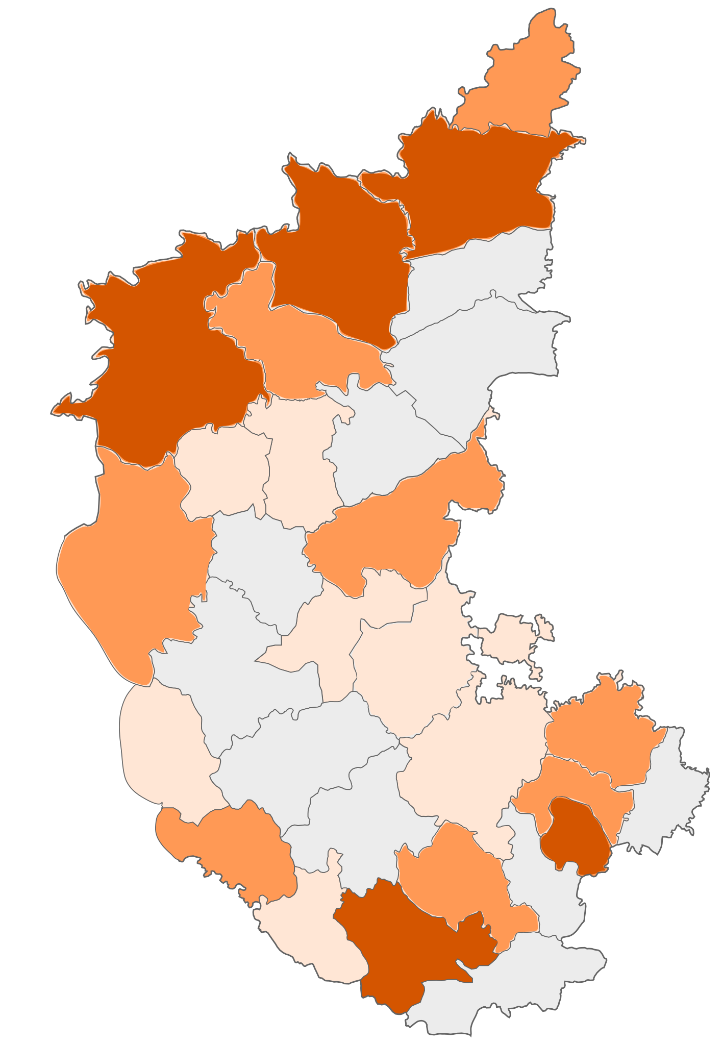
| వివరణ | COVID-19 affected districts in Karnataka state of India as of 7 April 2020. |
| తేదీ | (UTC) |
| మూలం | This file was derived from : |
| కర్త | Firos ak |


| This is a retouched picture, which means that it has been digitally altered from its original version. Modifications: marking COVID 19 district map. The original can be viewed here: India Karnataka COVID-19 map.png: |
లైసెన్సింగ్
ఈ దస్త్రం క్రియేటివ్ కామన్స్ Attribution-Share Alike 3.0 Unported లైసెన్సు క్రింద లభ్యం.
- ఇలా చేసేందుకు మీకు స్వేచ్ఛ ఉంది:
- పంచుకోడానికి – ఈ కృతిని కాపీ చేసుకోవచ్చు, పంపిణీ చేయవచ్చు, ప్రసారమూ చేయవచ్చు
- రీమిక్స్ చేయడానికి – కృతిని అనుకరించడానికి
- క్రింది షరతులకు లోబడి:
- ఆపాదింపు – సముచితమైన శ్రేయస్సును ఇవ్వాలి, లైసెన్సుకు లింకు ఇవ్వాలి, మార్పులేమైనా చేస్తే వాటిని సూచించాలి. అందుకు సముచితమైన పద్ధతి దేన్నైనా అవలంబించవచ్చు. కానీ మీకూ మీ వాడుకకూ హక్కుదారు అనుమతించారు అనే అర్థం వచ్చేటట్లుగా మాత్రం కాదు.
- share alike – మీరు ఈ కృతిని అనుకరిస్తే, మారిస్తే, లేదా మెరుగుపరిస్తే తత్ఫలిత కృతిని ఇదే లైసెన్సు లేదా దీనికి అనుగుణ్యమైన లైసెన్సు క్రింద మాత్రమే పంపిణీ చేయాలి.
అసలు ఎక్కింపుల చిట్టా
This image is a derivative work of the following images:
- File:India Karnataka location map.svg licensed with Cc-by-sa-3.0
- 2010-11-15T15:50:48Z Nayvik 1630x2356 (211689 Bytes) Changed background color
- 2010-11-15T15:34:13Z Nayvik 1630x2356 (211293 Bytes) {{Information |Description=Location map of [[:en:Karnataka|Karnataka]] Geographic limits of the map: * 18.5°N * 11.0°N * 73.6°E * 78.7°E |Source=*[[:File:Karnataka_locator_map.svg|]], [http://www.censusindia.gov.in/2011-I
- File:Karnataka locator map.svg licensed with Cc-by-sa-3.0
- 2010-11-20T10:48:54Z Nayvik 1630x2356 (240130 Bytes) Created 3 new districts [[:en:Chikballapur district|Chikballapur district]], [[:en:Ramanagara district|Ramanagara district]] and [[:en:Yadgir district|Yadgir district]]
- 2007-05-08T10:07:08Z Planemad 1630x2356 (231256 Bytes) chg color of chamarajanagar
- 2007-05-06T13:55:02Z Planemad 1630x2356 (231773 Bytes) {{WikiProject_India_Maps |Title=Karnataka locator Map |Description=Map of [[w:Karnataka]] with road and rail lines |Source= [http://aquarium.lipetsk.ru/discovery/India2004/karnataka-map.jpg Karnataka Map], [http://www.indianr
- File:India Karnataka COVID-19 map.png licensed with Cc-by-sa-3.0
- 2020-03-21T10:18:11Z Firos ak 1630x2356 (400039 Bytes) Removed Bangalore rural and added Chikballapur Dist.
- 2020-03-21T09:56:47Z Firos ak 1630x2356 (399619 Bytes) Added Bangalore rural
- 2020-03-21T08:17:25Z Firos ak 1630x2356 (397871 Bytes) Added Kodagu district
- 2020-03-17T09:22:44Z Shanze1 2608x3768 (686680 Bytes) fix
- 2020-03-17T09:17:26Z Shanze1 2379x3711 (702913 Bytes) transparency
- 2020-03-17T09:13:51Z Shanze1 1631x2357 (387099 Bytes) == {{int:filedesc}} == {{Information |Description=COVID-19 affected districts in Karnataka state of India as of 17 March 2020. |Source={{Derived from|India Karnataka location map.svg|display=50}} |Date=2020-03-17 09:10 (UTC)
Uploaded with derivativeFX
ఫైలు చరితం
తేదీ/సమయం ను నొక్కి ఆ సమయాన ఫైలు ఎలా ఉండేదో చూడవచ్చు.
| తేదీ/సమయం | నఖచిత్రం | కొలతలు | వాడుకరి | వ్యాఖ్య | |
|---|---|---|---|---|---|
| ప్రస్తుత | 14:27, 23 ఏప్రిల్ 2020 | | 1,630 × 2,356 (260 KB) | Prasannatb | Kalaburagi - 30+ Vijayapura - 30+ |
| 09:48, 17 ఏప్రిల్ 2020 |  | 1,630 × 2,356 (255 KB) | Prasannatb | Mandya - 10+, Ballari - 10+ | |
| 13:53, 16 ఏప్రిల్ 2020 |  | 1,630 × 2,356 (249 KB) | Prasannatb | Belagavi -30+ and Vijayapura - 10+ | |
| 17:11, 14 ఏప్రిల్ 2020 |  | 1,630 × 2,356 (238 KB) | Prasannatb | Chitradurga - 1+ | |
| 17:03, 14 ఏప్రిల్ 2020 |  | 1,630 × 2,356 (235 KB) | Prasannatb | Chikkaballapura, Bengaluru Rural, Uttara Kannada - 10+ | |
| 09:36, 14 ఏప్రిల్ 2020 |  | 1,630 × 2,356 (228 KB) | Prasannatb | Bagalkote - 10+ | |
| 08:31, 12 ఏప్రిల్ 2020 |  | 1,630 × 2,356 (225 KB) | Prasannatb | Vijayapura - +1 | |
| 08:47, 10 ఏప్రిల్ 2020 |  | 1,630 × 2,356 (222 KB) | Prasannatb | Kalaburagi - 10+ | |
| 14:24, 9 ఏప్రిల్ 2020 |  | 1,630 × 2,356 (218 KB) | Prasannatb | Belagavi - 10+ | |
| 15:28, 7 ఏప్రిల్ 2020 |  | 1,630 × 2,356 (212 KB) | Firos ak | 7 apr |
లింకులు
కింది పేజీలలో ఈ ఫైలుకు లింకులు ఉన్నాయి:
సార్వత్రిక ఫైలు వాడుక
ఈ దస్త్రాన్ని ఈ క్రింది ఇతర వికీలు ఉపయోగిస్తున్నాయి:
- en.wikipedia.org లో వాడుక
- kn.wikipedia.org లో వాడుక
- tcy.wikipedia.org లో వాడుక
- tr.wikipedia.org లో వాడుక
- ur.wikipedia.org లో వాడుక
- www.wikidata.org లో వాడుక
మెటాడేటా
🔥 Top keywords: మొదటి పేజీవై.ఎస్. జగన్మోహన్ రెడ్డిశ్రీ గౌరి ప్రియప్రత్యేక:అన్వేషణవికీపీడియా:Contact usపవిత్ర జయరామ్2024 ఆంధ్రప్రదేశ్ శాసనసభ ఎన్నికలుఈనాడువాతావరణంబైరెడ్డి సిద్ధార్థ్ రెడ్డితెలుగుమారొజు వీరన్న2019 ఆంధ్రప్రదేశ్ శాసనసభ ఎన్నికలుసాలార్ జంగ్ మ్యూజియంజే.సీ. ప్రభాకర రెడ్డియూట్యూబ్సిసింద్రీ చిట్టిబాబుఆంధ్రప్రదేశ్ శాసనసభ నియోజకవర్గాల జాబితావై.యస్.భారతికేతిరెడ్డి పెద్దారెడ్డిఆంధ్రప్రదేశ్పవన్ కళ్యాణ్సెక్స్ (అయోమయ నివృత్తి)తెలుగు అక్షరాలువంగా గీతగోనె ప్రకాశ్ రావుకుక్కుట శాస్త్రంనక్షత్రం (జ్యోతిషం)2024 భారత సార్వత్రిక ఎన్నికలుభారతదేశంలో కోడి పందాలుఆంధ్రప్రదేశ్ ముఖ్యమంత్రుల జాబితాఅంగుళంకార్తెరామాయణంపోతులూరి వీరబ్రహ్మేంద్రస్వామిసునీల్ ఛెత్రిఎనుముల రేవంత్ రెడ్డితెలంగాణ రాష్ట్ర రోడ్డు రవాణా సంస్థద్వాదశ జ్యోతిర్లింగాలు